Another trail that drops from the caprock escarpment down into the
canyon is the Eagle Point Trail, which runs for two miles from either
Lake Theo or the interpretive center north through a scenic canyon to
the far side of the park road near the Little Red River.
Here's a portion of the park map that shows the trail marked in
gold:

Click on this
link for a large pdf. version of the whole park map to
see this trail in context.
Eagle Point is another trail that is easy to access from the RV campground
(lower right in map).
It's a short run, walk, or bike ride to the interpretive center, which
is the trailhead we've always used.
There are grand views of the canyons to the north on the way to the
trailhead. In the next photo I've drawn an arrow to show Eagle's Point:
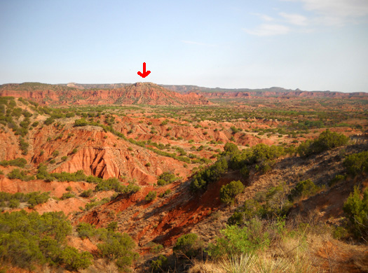
That was my destination the day I took these photos. Then I turned
around and came back.
Both Jim and I have gone out and back on this trail for a five-mile
trek from our campsite. Jim has also included the Eagle Point Trail in either direction in
large loops he's run that incorporated several other trails.
Eagle Point Trail starts out as a flat, sandy single-track path along
the rim for about 1/2 mile. This is one of the areas where the rangers
did a controlled burn over the winter:

There are more excellent views of the canyons along this part of the
trail. Once you know where to look, it's easy to see parts of the trail
that lie ahead:


After the intersection where the trail from Lake Theo meets the trail from the
interpretive center, Eagle Point Trail starts an abrupt roller-coaster
ride down into the canyon, sometimes rather steeply, on a wider, mostly
sandy trail. There is some loose rock and deep sand in some places but
the trail is fairly smooth in general:

Notice in the picture above that the burn area is to the right toward
the rim, and the unburned area is to the left toward the canyons. This
is another example of what I jokingly refer to as "schizoid" trails.
Because of their contrast, they can play a number on your mind as you're
running or hiking.
The layers of rocks in the canyon and the variety of bottomland
plants are very interesting as you look around during the descent.
There's even some prairie grass down there:


Once down in the canyons the trail continues its
roller-coaster ride up and down small hills. It affords nice views of
Eagle's Point in the outbound direction and close-up views of 280
million years of rock
layers:


The trail crosses two or three small streams that were dry this week:

It also climbs to a natural bridge, which we crossed several times
last year without seeing the cool opening underneath it.

We both noticed the ravine on either side of the trail but didn't
think we could get down to it very easily. This is the rock wall on the
east side of the bridge:


Turns out, there's a little trail on the other side of the bridge
that rather easily accesses the opening. I would
have missed it again this year if a couple I talked with on the trail
hadn't told me about it.
Eagle Point Trail goes across the top of the "bridge" where I drew
the arrow below.
A short side trail to the west takes curious hikers down here:


Because of all the large boulders in the opening I didn't try to walk
through it but folks who enjoy rock scrambling would have fun doing that.
The northern trailhead is about one-third of a mile uphill from the
natural bridge.
At this point you're in the shadow of Eagle Point. There is a parking
area about one-fourth mile west on the park road from that trailhead.

I took the remaining photos on the way back to the campground:


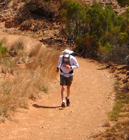
Near the end of my hike Jim surprised Cody and me by running up from
behind us. He was finishing up one of his long loops through the canyons:

You can see other photos from this trail in an
entry I wrote about it last year. I've tried to include some
different views this time.
Next entry: exploring the Lower Canyon Loop
Happy trails,
Sue
"Runtrails & Company" - Sue Norwood, Jim O'Neil,
and Cody the Ultra Lab
Previous
Next
© 2011 Sue Norwood and Jim O'Neil
