"Laz" is one of our running friends who has a way with words. Although
he wrote the above comment in a post about racing to the online ultra running forum
back in January, I thought about it today when I was clawing my way up a
very rough section of the Waterfall Trail on my way to Franconia Ridge
-- and sliding down slick bedrock on the Old Bridle Path descent.
I wasn't in a race or in a hurry walking but I could relate to
the comment -- even though the rough trails weren't kind to my
aging joints, I still love to explore places that are new to me. It's fun.
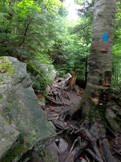
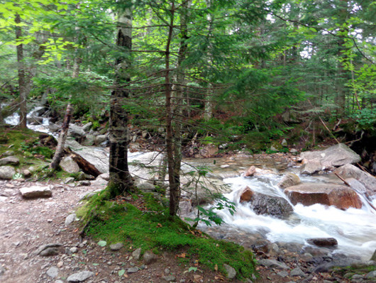
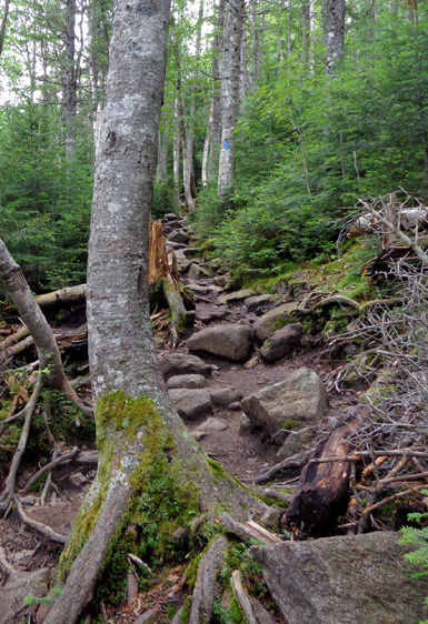
The Waterfall Trail is a sub-alpine
jungle of roots and rocks.
I also love going back to some of my favorite sections of the
Appalachian Trail from my Adventure Run in 2005. Franconia Ridge was in
my Top Five and I've been wanting to go back ever since.
Even back then, though, I wasn't able to do the entire ridgeline from
Franconia Notch to Crawford Notch in one day. I spent the night of Day
118 at Galehead Hut, the only night I wasn't in our camper overnight
during that entire trek from Georgia to Maine.
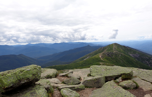
View south from the summit of Little Haystack
Mountain; I hiked north on the ridge.
Today I knew I'd have to use one or more of the shorter side trails
that access the ridge and either do a loop or an out-and-back hike.
Poring over the topo maps Eric loaned us, I chose to do a nine-mile loop
incorporating the Falling Waters, Greenleaf, and Old Bridle Path trails.
Eric suggested I do it clockwise. When I saw that the elevation profile was
steeper on the shorter Falling Waters Trail, I decided to go counter-clockwise. I can
climb up steep trails more easily than I can descend them (those doggone
Granny Knees!).
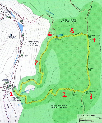
1 = start/end; 2 = Falling Waters Trail;
3 = summit of Little Haystack Mtn. on
Franconia Ridge to summit of Mt. Lafayette (4);
5 = Greenleaf Trail;
6 = Greenleaf Hut; 7 = Old Bridle Trail
In retrospect, I think going CCW was the better choice for me. The
descent was difficult on the Old Bridle Path but I know it would have
been even more tedious and treacherous for me on the Falling Waters
Trail, especially when I was more tired in the last third of my hike.
In addition, on Falling Waters I could see all the waterfalls and
cascades better going uphill than I could have going downhill.
The real prize was hiking several miles along Franconia Ridge, with
fantastic views of the White Mountains in every direction. Up there, it
doesn't matter which way you're hiking. I often stopped to look behind
me to see what I was missing in the other direction:
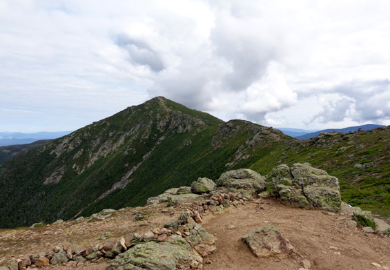
View north from Little Haystack
Mtn. to Mt. Lafayette
View south along Franconia Ridge
from Mt. Lafayette
In this multi-page entry I'll describe my nine-mile hike, which took
me about nine hours because of three leisurely snack breaks and stopping
numerous times to take over 400 photos.
I tried to go slowly enough to enjoy the scenery, as well as to
protect my knees as much as possible.
When am
I going to learn that virtually no trail in the White Mountains is
"easy," especially now that I'm not trained as well as I was when I ran
and hiked the Appalachian Trail nine years
ago -- and my knees have aged much more than that???
GETTING AN EARLY START
This was a pretty day that started earlier than usual for me. I got up about
5:30 AM when I saw that it was already light outside.
I checked the NOAA
site before getting ready to go. Overnight, the weather prediction for
Twin Mountain deteriorated -- a 40% chance of rain after noon,
not 30% after 2 PM. Uh, oh!
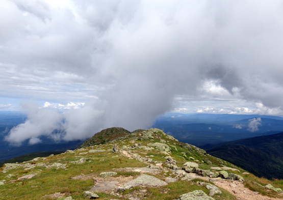
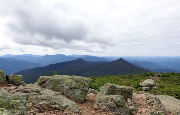
Clouds were increasing above the ridge about 12 noon
while I sat on the
summit of Mt. Lafayette, enjoying my lunch and
looking north in this photo.
I knew the chance for rain was probably higher on Franconia Ridge than
down in the valley, so I got going as quickly as I could. Over three
miles of this loop are above treeline. By starting my hike about 7 AM I
was able to get up to the ridge by 10 AM and down
to treeline at the Greenleaf Hut by 1 PM.
Fortunately, the weather was good on the ridge all day -- some
clouds in the morning but mostly sunny all afternoon. It was just as
nice on the ridge as it was when I was there nine years ago, with fewer
clouds blowing over the peaks of Little Haystack, Lincoln, and
Lafayette.
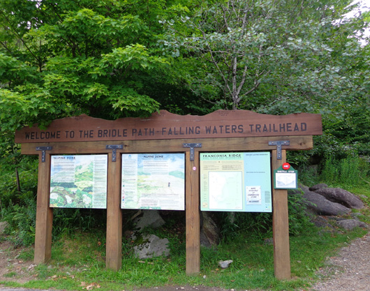
There were very few vehicles in the Old Bridle Path-Falling Waters trailhead
parking area when I arrived just before 7 AM, much different from the
scene on Saturday when cars were parked out along I-93, an interstate
"parkway" with a 45 MPH speed limit through Franconia Notch.
Near the trailhead a large group of teenagers
was waiting to begin the same CCW loop hike I was doing. I like peace
and quiet when I hike, so when I heard their plan I moved along and
managed to stay ahead of them until 1/4 mile from the end. Plenty of 20-
and 30-somethings passed me all day, however. I saw only one person who
looked older than me on these trails today.
I was a bit surprised there were so many folks on the trails for a
weekday, but it is the height of summer and this is a popular hike
despite the gnarly trails.
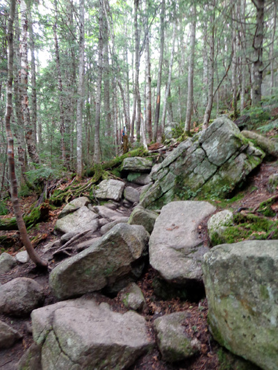
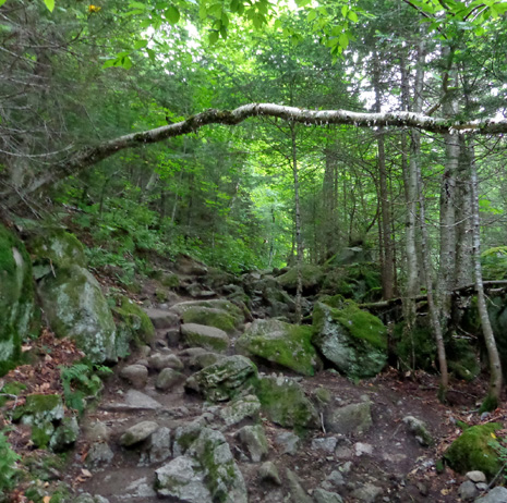
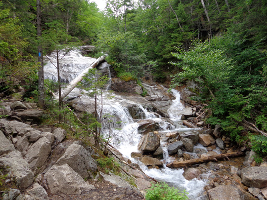
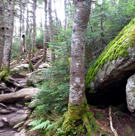
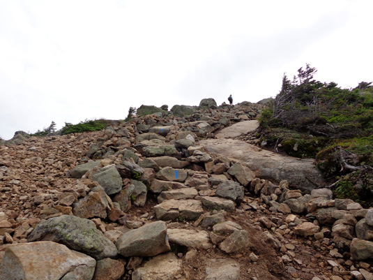
ASCENT ON THE FALLING WATERS TRAIL
The first couple
miles of this trail are interesting but gnarly.
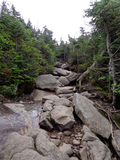
There were a bunch of stream crossings and I was in knee-deep water two or
three times. With two trekking poles, I didn't slip on any slick rocks
or fear any of the water crossings. The water levels are pretty low
right now. After a hard rain, during the spring thaw, or in icy
conditions this trail could be downright dangerous.
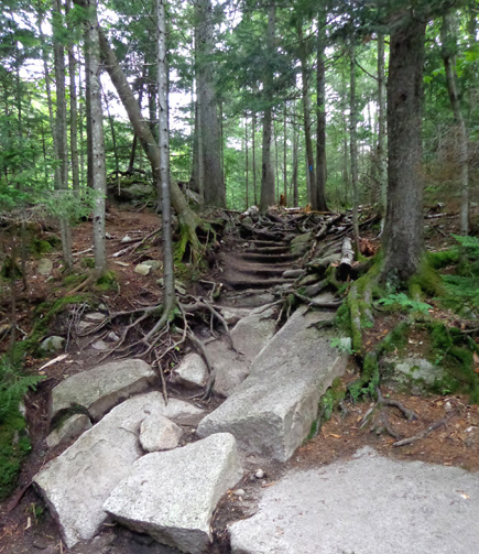
The bigger problem for me today was all the roots and rocks and steep
inclines:
Here is most of the description of the Falling Waters Trail from the
White Mountains Guide produced by the AMC (Appalachian Mountain
Club):
This trail begins at the Lafayette Place parking lots . . . and climbs
to Franconia Ridge Trail at the summit of Little Haystack Mountain, passing
several waterfalls in its lower part. Falling Waters Trail is steep and
rough in parts and better for ascent than descent, but not normally
dangerous . . .
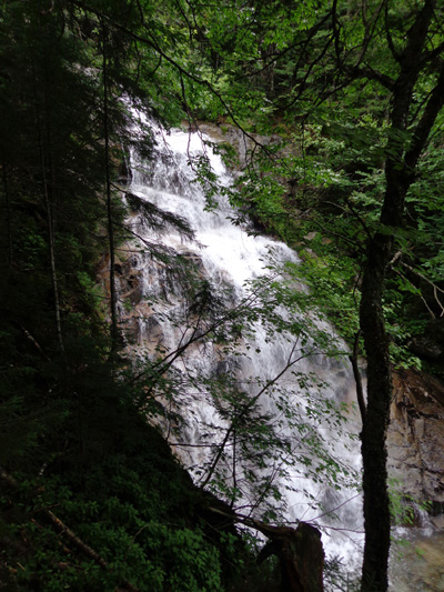
Walker Brook
in the first 2/10 mile
. . . At 0.2 mi., the trail turns sharply right from Old Bridle Path and
immediately crosses Walker Brook on a bridge . . .
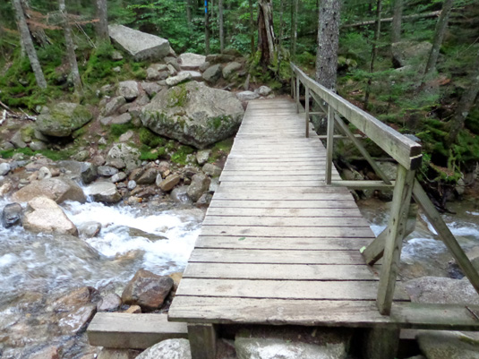
And that's
the only bridge I saw on this loop!
At 0.7 mi. . . . Falling Waters Trail crosses Dry Brook (use caution if the water is
high) . . . and follows the south bank up to a beautiful cascade
known as Stairs Falls.
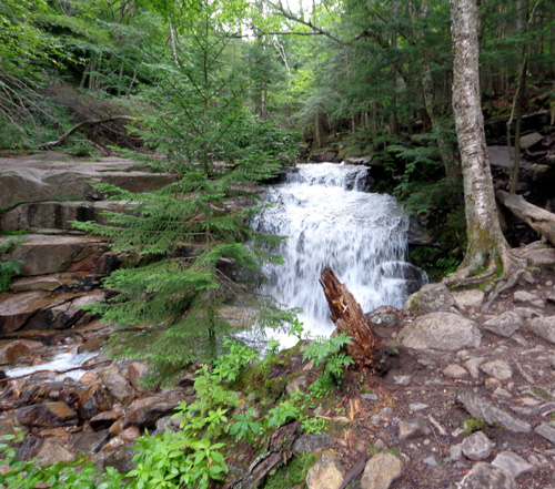
Above the falls, the trail passes beneath Sawteeth Ledges and crosses
the brook to the north bank just below Swiftwater Falls, which descends
60 ft. in a shady glen, then climbs a steep rock staircase to the north
bank and follows an old logging road that rises gradually in the narrow
gorge of Dry Brook. [As narrow as the trail
was there, I can't imagine it was ever a logging "road."]
I'd been hiking for about an hour (only 1.25 miles) when the
first two hikers passed me. Until then I wondered if I was the only one
on the trail. I liked the solitude but was a little concerned that if I
got into trouble, there wouldn't be anyone around to help.
No problem -- the young men said there were "a bunch" of hikers
behind me. Another ten passed me before I reached the ridge, and there
were more behind them.
The guide continues:
The trail leaves the old road at a steep embankment and ascends more
roughly to the foot of Cloudland Falls (80 ft. high) at 1.3 mi. The
trail then climbs steeply up the bank of the brook beside the fall, with
a dropoff to the right . . .
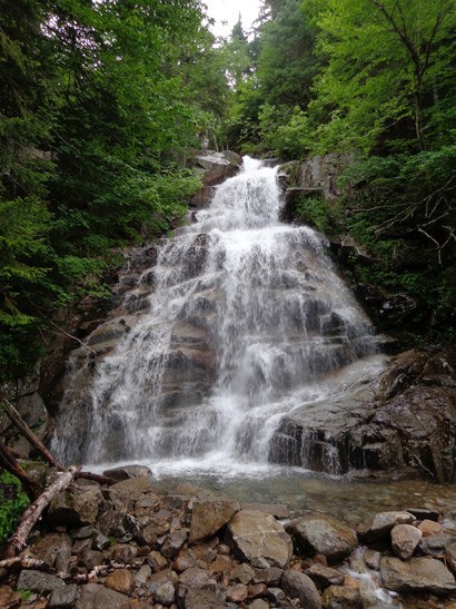
Recently cut rock steps aid in a ledgy
scramble to the top of the falls . . .
At the head of Cloudland Falls are two small (25 ft.) falls practically
facing each other . . .
[one
is a branch of Dry Brook that runs down from Little Haystack Mtn., the
other from Mt. Lincoln].
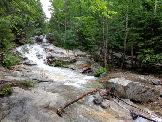
The trail continues steeply on the north bank of
the Mt. Lincoln branch, soon crosses to the south bank, crosses back to
the north side, climbs to and follows an old logging road
[again, I couldn't recognize that this was ever a roadway], and
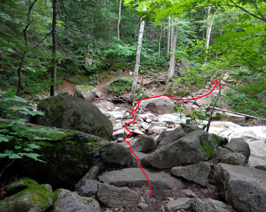
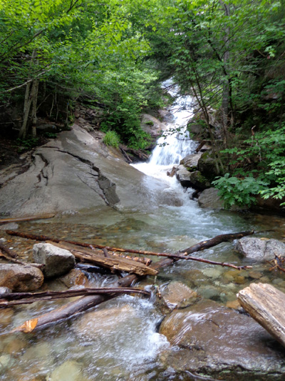
recrosses to the south bank at 1.6 mi.
Last stream crossing
on the ascent
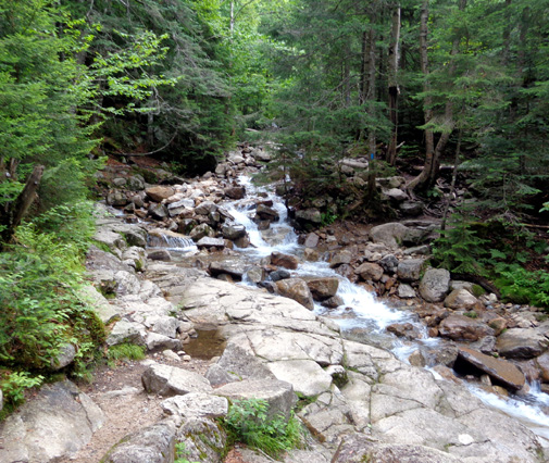
After this, the trail swings away from the stream and switchbacks the
rest of the way up to the ridge. The trail continues to be very rocky
and rooty and my pace continued to be very slow.
Five trail workers were installing new rock and log water breaks in four
areas between the last stream and the ridge. I stopped to thank each of
them. Jim and I have done work on the Appalachian Trail and we know that
it's a hard job.
Above and below: By this point I was feeling pretty miserable
but smiling when I remembered Laz's quote at the top of this page!
Despite the gnarly trail, my mood brightened
considerably when I knew I was getting close to the ridge:
Soon after the junction with the Shining Rock Trail spur three miles
into my hike, the Falling Waters Trail finally pops out of the woods and
onto the open 4,780' peak of Little Haystack Mountain.
The final pitch is
above treeline and I could finally see some views to the north:
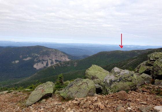
I had about three more miles of hiking to reach
Greenleaf Hut, under the red arrow.
I was hoping to get there in two hours but it took me closer to three
hours to go the first 3.2 miles.
I was happy to reach the ridge and finally see
some sunshine. The clouds were mostly white, not looking at all like
rain, and there was only a little breeze. It was perfect, and I loved
the 360-degree views.
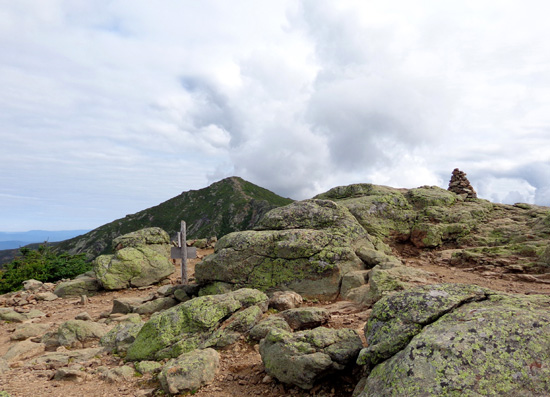
Made it to the summit of Little Haystack! Lafayette's
peak is in the distance, just under two miles on foot.
As soon as I got up there I realized the difficult hike up was worth it
and I tried to forget how hard it was probably going to be to descend in
another couple hours.
Continued on the next
page: awesome views on the Appalachian Trail along Franconia Ridge
Happy trails,
Sue
"Runtrails & Company" - Sue Norwood, Jim O'Neil,
Cody the ultra Lab, and Casey-pup
Previous
Next
© 2014 Sue Norwood and Jim O'Neil
