Bears are also seen along this trail so I took
my bear spray with me.
This was my second hike today. After walking 2+ miles on the
falls trail
I drove about 11 miles to the trailhead for Twin Peaks. It is at the end
of Eklutna (ee-KLOOT-na) Lake Road, where Jim and I parked
last week
when we rode our bikes on the Lakeside Trail.
I hiked out-and-back a little over 6 miles on the Twin Peaks Trail, for
a total of about 8.3 miles today.
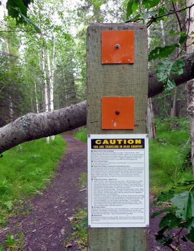
CAUTION: You
Are Traveling In Bear Country
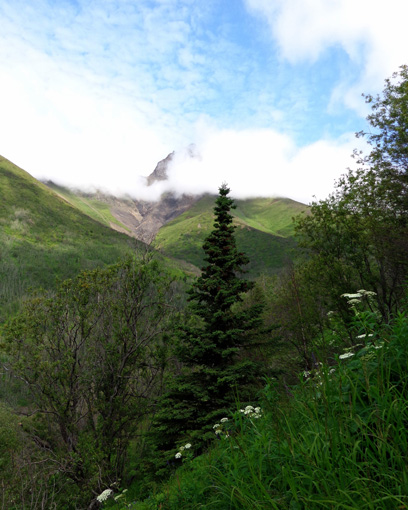
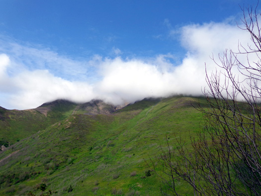
The sky was mostly overcast/cloudy in the morning while I was at
Thunderbird Falls and for much of my ascent on the Twin Peaks Trail.
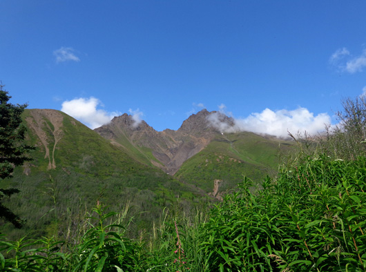
Clouds mostly hid the jagged summits of the Twin Peaks (East Twin Peak and West
Twin Peak) and nearby Goat Rock on the way up to the tundra.
East Twin Peak, on the right in my photos, is the taller of the "Twins"
at 5,873 feet. The west peak is 5,472 feet tall and Goat Rock is 5,249
feet high.
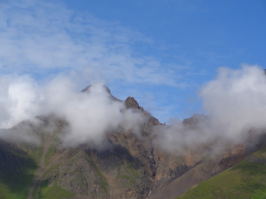
Fortunately, the clouds gradually decreased and it was more sunny while
I was up in the alpine meadows and on the way back down.
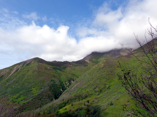
Ironically, the very last time I could see the rocky Twin Peaks summits
behind me as I was descending . . . was the very best view with the
fewest clouds:
At that point I just didn't have time to go back up to the ridge for
more pictures.
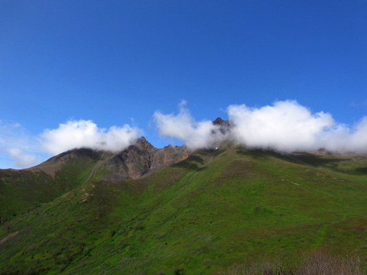
I must admit, however, that the Twin Peaks looked very cool playing hide
and seek with the small clouds that just wouldn't seem to go away
most of the time I was up there:
Use of the trails and
facilities at Eklutna Lake is free if you have an annual Chugach State
Park Pass. The lake is in the northern part of this huge park that
covers half a million acres of mountainous terrain just east of Anchorage.
Visitors without the
annual pass must pay $5/day to enjoy the lake area. Since I'd already
paid at Thunderbird Falls this morning, I didn't have to pay again;
I just displayed the receipt on the dash.
The main parking area is a few hundred yards from the trailhead for the
Twin Peaks Trail. It starts with the Lakeside Trail, then branches off
after a few hundred yards:
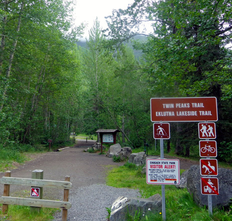
Cyclists can use the Lakeside Trail but not the
Twin Peaks Trail.
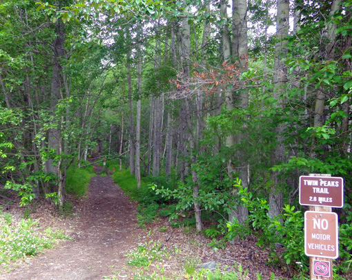
Beginning of
Twin Peaks Trail; I think equestrians can use this trail.
There were perhaps a dozen vehicles in the main parking area and a few
more in another parking area for folks with ATVs. Off-road vehicles are
permitted on the Lakeside Trail several days of the week, including
today. No bikes or ORVs are allowed on the Twin Peaks Trail.
I saw only two people coming down the trail near the beginning and five
people up on the ridge halfway through my hike. I liked the solitude I
had for most of the hike.
WHAT BEARS?
Since we were going through forest and some brush the first 2˝
miles
and there weren’t very many people around, Cody and I each wore bear
bells and I carried bear spray.
Alas, we didn't see any bears, just some bear scat in the middle of the
trail about two miles up from the trailhead:
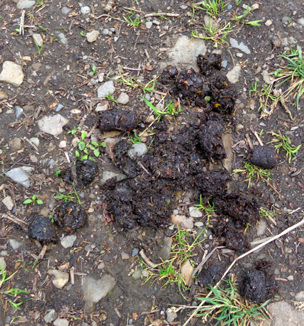
There are berries in the bear scat but no bear
bells . . .
That's also where I got my first
views of the East Twin Peak and the trail became more narrow and overgrown as
it hugged the mountainside -- not a real good place to meet a bear.
The only critters I saw were an eagle
soaring overhead above the ridge of the unnamed mountain I was on while
I was wandering above tree line and some Dall
sheep in the distance on the flanks of "The Twins."
I got pictures of the eagle and sheep but none of the critters were close enough
to see them clearly in my shots,
even with a 16-megapixel lens (I didn't zoom in on the sheep when taking the photos,
only when editing them).
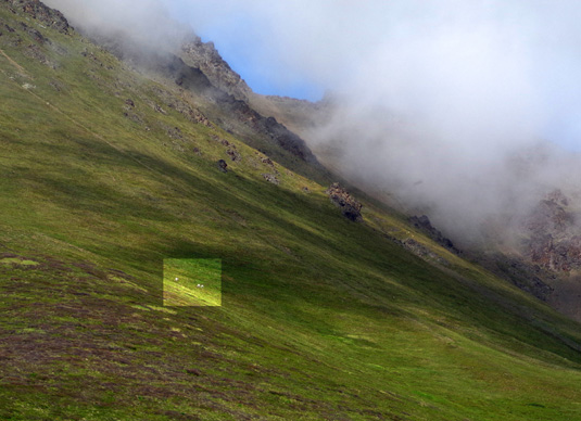
The three white spots highlighted in the next
picture are Dall sheep. Trust me:
I'll try to get closer to some sheep before we leave Alaska. And next time we're
up here I'll definitely have a higher-powered DSLR like so many other
tourists we've seen . . .
TERRAIN & TRAIL SURFACES
This trail has a good amount of elevation gain and loss.
One of the Chugach State Park web
pages says the gain is 1500 feet in 2.5
miles. A different
page on the same site says the gain is
1800 feet in 2.6 miles. My GPS agrees more with the latter. These
descriptions are for the official trail, which stops at a wooden bench
near timberline.
I went half a mile farther than that through the tundra above the bench.
I started and ended at 951 feet and topped out at 3,340 feet on the
ridge where I turned around at 3+ miles, a net gain of 2,389 feet the
way I did it. There were some other ups and downs in addition to the net
gain and loss.
This trail is designated by the two official park sites above as
“moderate" to "difficult,” depending on how far
you go. I agree with that.
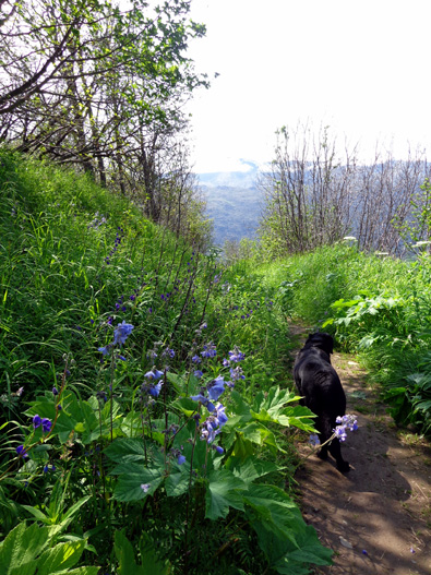
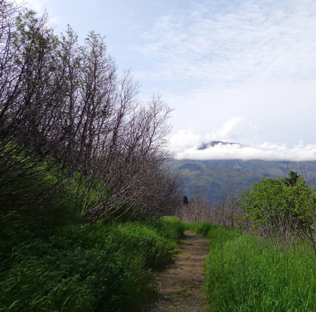
Cody leads the way as we descend through the low
sub-alpine shrubs and trees.
Although somewhat
steep, there are numerous switchbacks and
the trail is fairly well maintained for the first 2.6 miles to
the second wooden bench. With about 1,800 feet of gain in that distance,
that's the "moderate" part.
Hiking above that in the tundra is more difficult, with some steep,
loose footing, rough, narrow trails, and a long way down if you slide off.
I went another half mile beyond that bench and could have wandered
around the alpine meadows and ridges a lot more than that if I'd had more time.
I'll show photos from the tundra later in this entry.
The first mile of the trail is an old Jeep road that was built by the
U.S. Army. It’s fairly smooth and more narrow now than it used to be:
Part way up I was surprised to see an old car about 50 feet down the
steep hillside:
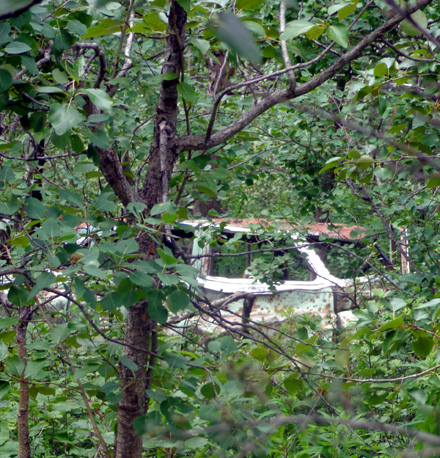
It reminded me of the old clunker nose down on the "Car Trail" on Mill
Mountain in Roanoke. What possesses people to do that??
Anyway, the old road going up to Twin Peaks is overgrown enough now that you
could drive a little Jeep up part way
but not a larger vehicle like the rusted one in the photo above.
HERE, HAVE A SEAT
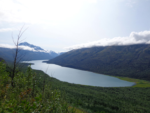
There are two wooden benches where people can sit on the way up this trail. The
first one is at the top of a steep, open section of trail with expansive
views of Lake Eklutna:
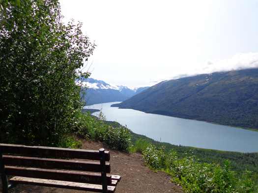
Some view,
eh? You can see most of the length of 7-mile-long Eklutna Lake
from this spot.
Before that the trail
switchbacks through fairly dense forest with few to no views of the lake.
Then, suddenly, you have stunning views of the lake and Eklutna Glacier for a couple hundred
yards. The trail is rather steep here so take time to stop a few times, admire the
scenery, and take photos:
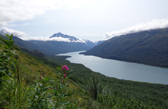
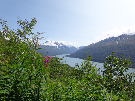
Pink fireweeds grow along the trail overlooking
Eklutna Lake.
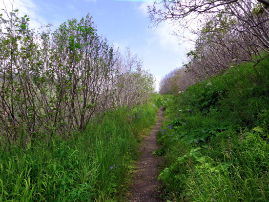
When you get to the first bench don't just stop there and go back down.
Keep going. The trail narrows as it climbs toward the tundra but it isn't
steep.
In about a quarter mile you'll round a bend and can start to see the
Twin Peaks as the trees get shorter and thin out. I got increasingly
better views of the jagged Teton-like peaks as I ascended, although
clouds mostly obscured the very tops the first 30-40 minutes I was up
there.
Two-point-six miles from the trailhead you'll be facing East Twin Pass
and come to the second bench, highlighted
in the distance below. The bench overlooks the Twin Peaks and Goat Rock,
which are out of view to the left in the next photo:
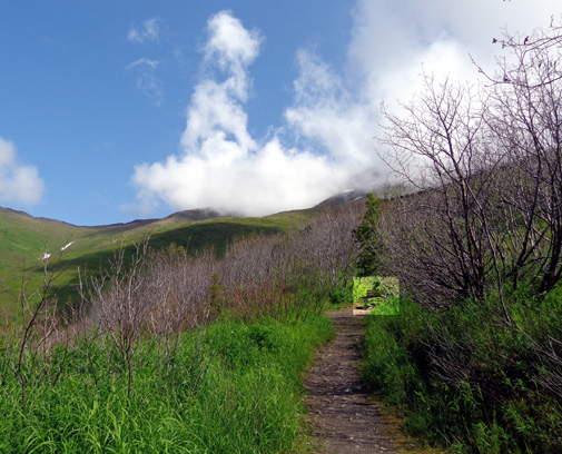
East Twin Pass is in the distance on the left side
of this photo.
The elevation at this bench is about 2,600 or 2,700 feet.
When I reached the bench on the way up a 30-something dad and his two
pre-teenage sons were just
leaving. They showed me where to see some Dall sheep, then began climbing
higher into the tundra.
From near the bench
I took the next two pictures of "the Twins" toward the north and west but
clouds covered the peaks just then:
Above and below: the Twin Peaks are in hiding
temporarily
I took the next photo near the bench when I was descending about 45
minutes later and I could see the rocky peaks better:
You can see the pointy East Twin Peak on the right and West Twin Peak on
the left. Goat Rock is under the cloud left of the west peak.
This wooden bench is the official end of the maintained part of Twin Peaks Trail.
I’m guessing a lot of people turn around at that point because the trail
becomes more steep and gnarly right past the bench.
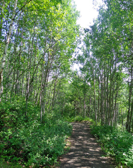
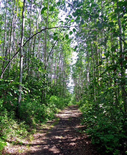
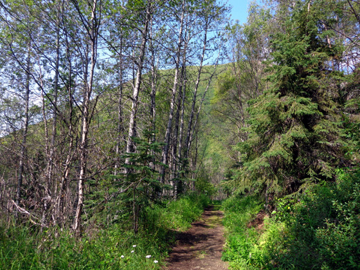
FLORA THE FIRST 2.6 MILES
The trail is mostly shaded with very tall trees the first couple of
miles – primarily aspens and birches at the lower elevations, with more
spruce and firs higher up:
I caught a glimpse of the lake through the trees after perhaps a mile
. . .
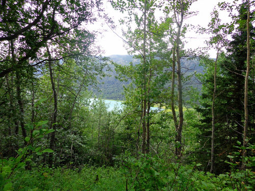
. . . but
there aren’t any unobstructed views toward the lake or other mountains
until you’re up at about 2,000 feet elevation, just before reaching the
first bench.
The views of the lake and the mountains to the east and south are
excellent at that point:
Then the trail heads back into the woods on the west and north sides of
the mountain I was climbing.
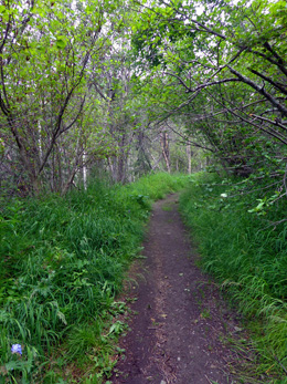
Within the next half mile the aspens, birch, spruce, and fir trees thin
out and are gradually replaced by lower sub-alpine trees and shrubbery:
The second bench is located where
tree line morphs into alpine meadows and tundra.
Continued on the next page . . .
pretty wildflowers all along the trail + panoramic scenes from the tundra
Happy trails,
Sue
"Runtrails & Company" - Sue Norwood, Jim O'Neil,
and Cody the ultra Lab
Previous
Next
© 2012 Sue Norwood and Jim O'Neil
