It took me almost 70 years to finally visit Hoover Dam, although I've
traveled in the Las Vegas area several times previously. Jim has been
there previously but it's been many years. So we thought seeing the dam would be
something different for us to do on this trip.Except for the partial
government shutdown that (partially) affected several of our plans to
visit federal lands while we were in Nevada this month, it was otherwise
a pretty good day to visit Hoover Dam. We were glad it was still open to
visitors.
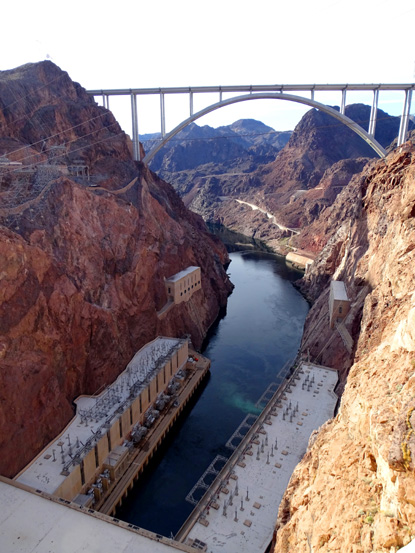
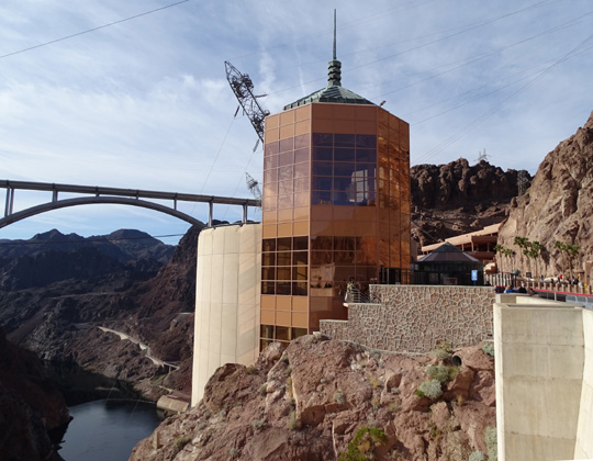
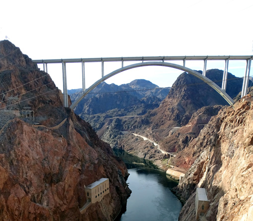
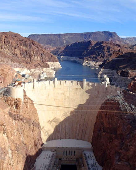
The best overall views of the dam and power plant
are from the
pedestrian walkway on the Memorial Bridge on Hwy.
93.
The weather was perfect, the dam area wasn't very crowded on this
weekday morning (January and February are the slowest visitation
months), and volunteers took the place of some government personnel
affected by the partial shutdown.
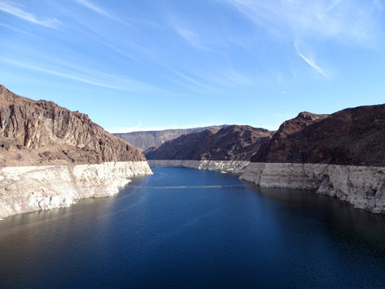
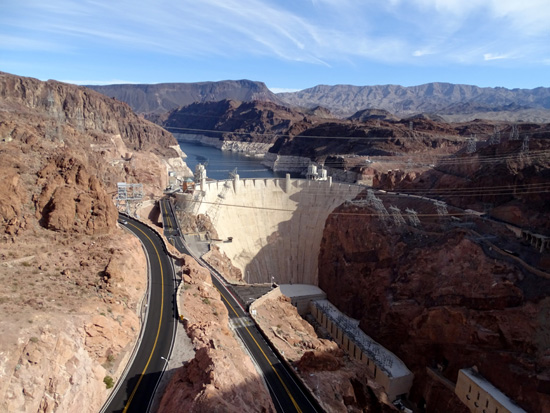
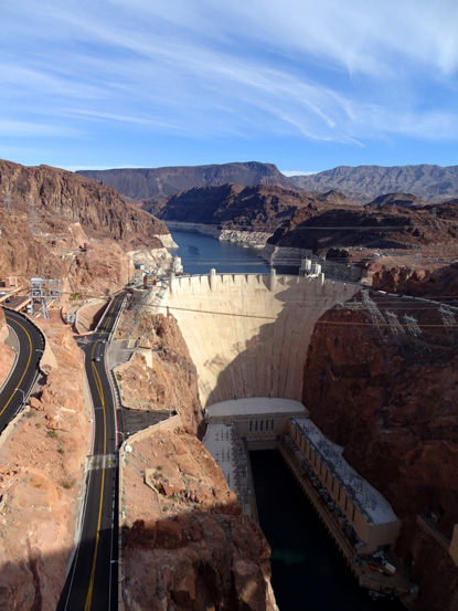
In addition, Lake Mead is at about normal depth now, not real low
from the many years of recent drought. I was as interested in the lake
scenery at and near Hoover Dam as the dam itself, and I wasn't
disappointed by its beauty:
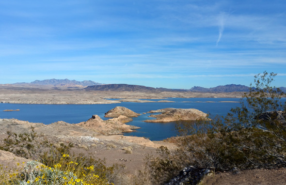
Lake Mead several miles north of Hoover Dam
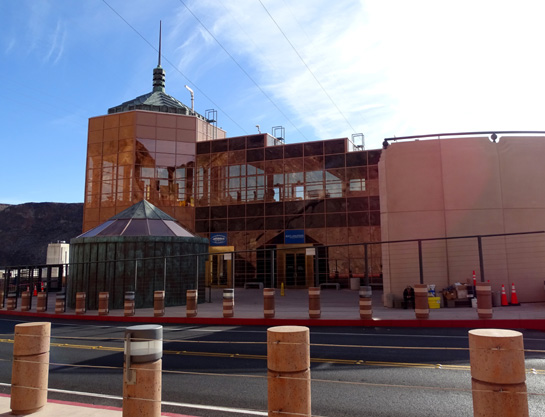
The visitor center and main elevator down into the dam are under
renovation this winter but it wasn't a big deal to us to miss those
features. For one thing, we left the dogs at the RV park and didn't want
to be gone all day. And there were plenty of interpretive signs along
the walkways and overlook bridge for us to read to understand the
history and significance of this impressive structure.
We had also read enough information online before we even got there so we'd
know what to expect, what was closed, and what we wanted to do.
WHY IS HOOVER DAM SO SIGNIFICANT?
Water management is a big deal in the arid states in the western
third of the United States, often underestimated by folks who live east
of the Mississippi River. Individuals and groups have been feuding over
water rights since early pioneers began claiming territory in the West.
(They still do.)
Enter the Bureau of Reclamation in 1902. This government agency
constructed and monitors over 600 dams and reservoirs, power plants, and
canals in seventeen western states, projects that facilitated homesteading
and economic development in the West.
Power plants at Hoover
Dam
Hoover Dam is one of several dams that were built to control the
1,400-mile-long Colorado River to prevent flooding; store water for
irrigation, municipal, and industrial use; and provide hydroelectric
power, fish and wildlife habitat, and recreational opportunities.
Seven western states and Mexico share the waters of the Colorado
River and its tributaries. Various treaties and contracts determine how
the water is apportioned to each state and for what uses. I've read just
enough about it to know it's complicated.
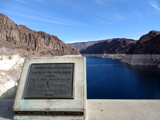
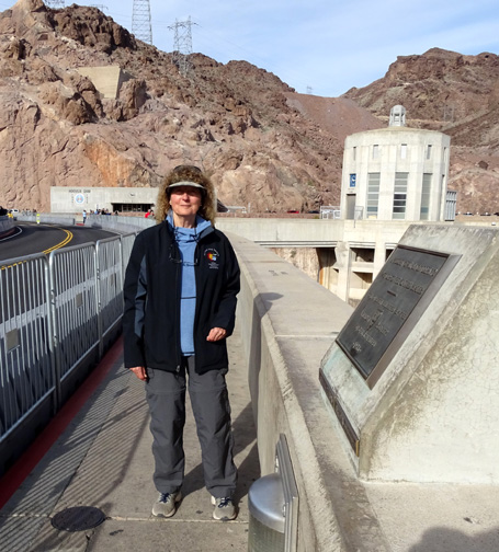
Plaque commemorating this as "A
modern civil engineering wonder of the United States," one of seven
selected by the American Society
of Civil Engineers; the plaque shows the NV/AZ state line.
Construction of this dam on the state line between Arizona and Nevada
was also quite complicated, more than I want to get into here. You can
find all sorts of general and detailed information on the Reclamation website, starting at
this link with common FAQs, and the
National Park Service website.
Wander around those websites for lots of interesting stories about the
construction of the dam and the bridge overlooking it,
historical and modern photos, special events, and touring information.
WHY IS THIS DAM A POPULAR TOURIST ATTRACTION?
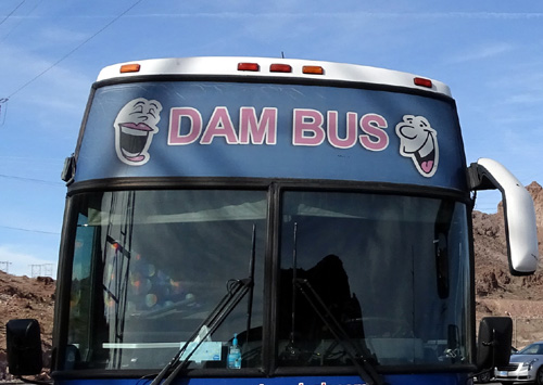
Because it's so dam impressive??
OK, that's a poor attempt at some humor. But then, so is the tour bus
with the sign on it that says "DAM BUS." I can just hear the
driver and passengers joking about getting on the dam(n) bus:
Because Hoover Dam is a National Historic Landmark, it is part of the
National Park System. Approximately
seven million visitors from around the world come to see this impressive
structure every year. Despite the heat, the busiest time to visit is
from Memorial Day to Labor Day.
The dam itself is a massive concrete arch-gravity structure that is
660 feet thick at its base, 726 feet tall, and wide enough at the top
that it still carries some vehicular traffic from old U.S. 93.
Fortunately, most of that traffic now zooms by on the recently-built
bypass bridge which soars over the canyon just downstream
from the dam:
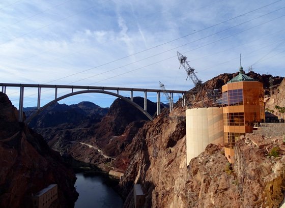
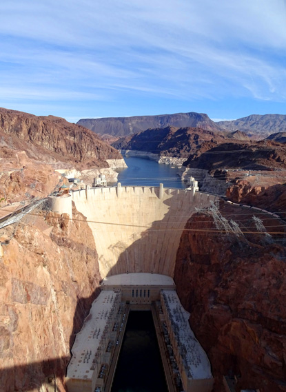
There is also a protected walkway for pedestrians high up on that bridge,
offering spectacular views of the dam, river, and Lake Mead. That's
where I took the first picture in this entry. I'll show
some more photos from the bridge later on.
Visitors can still choose to drive over the dam but not many people
were doing that this morning. We wanted to read signs and see more
things by walking over it, so we parked in the high-rise parking
deck on the Nevada side of the river.
SOME LOGISTICS
The nearest town to the dam is Boulder City, which is on US 93
southeast of Las Vegas and Henderson, NV.
Instead of taking freeways through metro Vegas today, we drove out and back from our
campsite at Nellis AFB in the north end of the city via Lake Mead Blvd. (NV 147) and
Lakeshore Road, which dead ends at US 93 a few miles west of Hoover Dam.
That's a very scenic route along the lake through the southern part of
Lake Mead National Recreation Area:
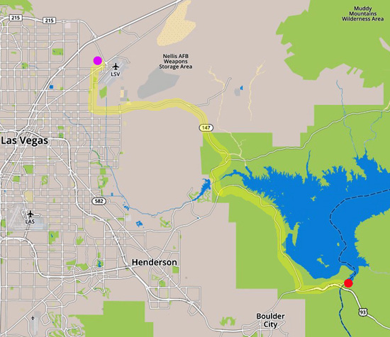
Purple dot = RV park at Nellis AFB; red dot =
Hoover Dam
Although some facilities in the NRA are closed due to the partial
government shutdown (this is Day 21 of the shutdown), the roads are open
and no one was collecting entrance fees. We get in free with our senior
national parks passes, so that didn't affect us. The NRA is losing
money, though, from loss of gate fees, camping and concession fees, etc.
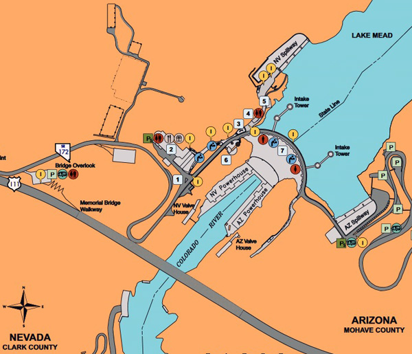
We took narrow, winding SR 172 off US 93, following signs down to the dam.
Well before reaching the dam itself all vehicles coming in from either the
Nevada or Arizona side are inspected for weapons, bombs, etc. The security guard
wanted to see inside our truck but no one asked us for our IDs today.
We paid $10 to park in a high-rise deck on the Nevada side of the
dam, near the visitor center (#2 on the
map below). There is some free parking on the Arizona
side of the dam, and room for larger RVs.
Hoover Dam is open to the public every day from 5 AM to 9 PM, per
this government
webpage. You can see it for free if you
don't park in the deck or want to do a tour. Check the website for current
tour times, descriptions, and costs.
As mentioned earlier, the visitor center and access to the power plants are under
renovation so we weren't able to go into those places today.
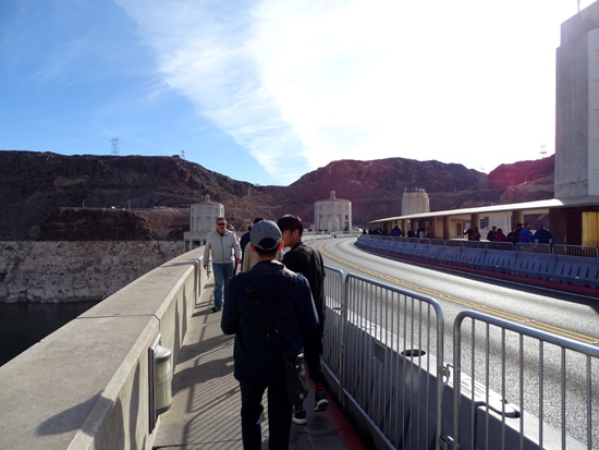
We spent about an hour meandering around the top of the dam to the other side
and back, reading lots of informative panels and plaques along the way,
and admiring the immense size of the dam, intake towers, and powerhouses.
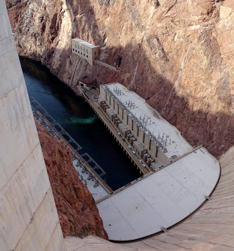
It's a long, slippery slope down
to the powerhouses from this perspective!
It's hard to comprehend the scale of the place unless
you're standing on top of the dam (picture above) or up on the memorial bridge walkway
. . . and looking down at the miniature people and vehicles so far
below you at the powerplants.
PHOTOS FROM THE TOP OF THE DAM
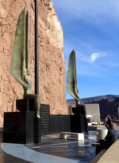
The walkway from the parking deck to the top of the dam goes past
several interpretive panels and the attractive "Winged Figures of
the Republic" plaza:
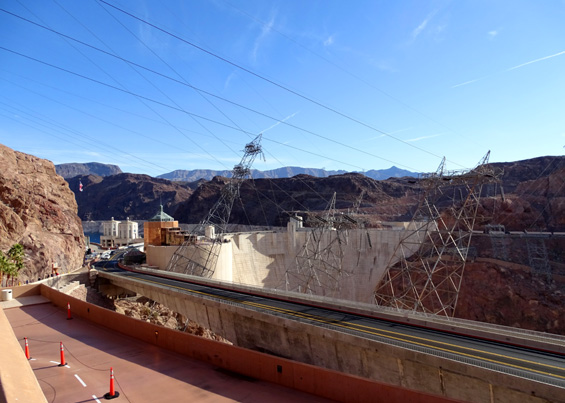
View of some power lines and dam
from parking deck (above); visitor center (below)
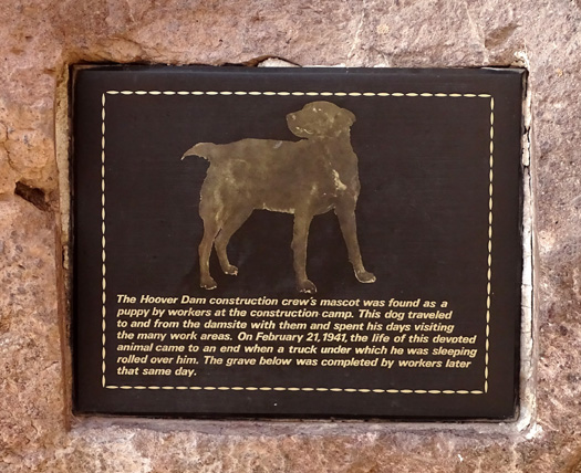
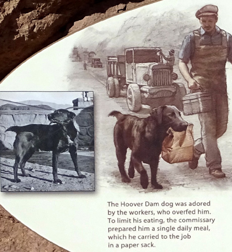
Nice tribute to the black Lab (?)
who became the worker's mascot
at the construction camp. Below is part of the panel describing his role.
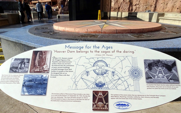
There are lots of Art Deco architectural details in and around Hoover
Dam, as described on panels at the Winged Figures plaza:
We walked back and forth across the top of the dam from
the Nevada to the Arizona side. Here are some additional photos from
that perspective:
We could walk on both sides of
the dam.
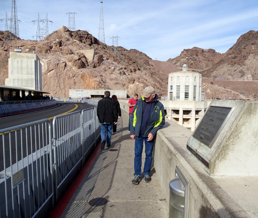
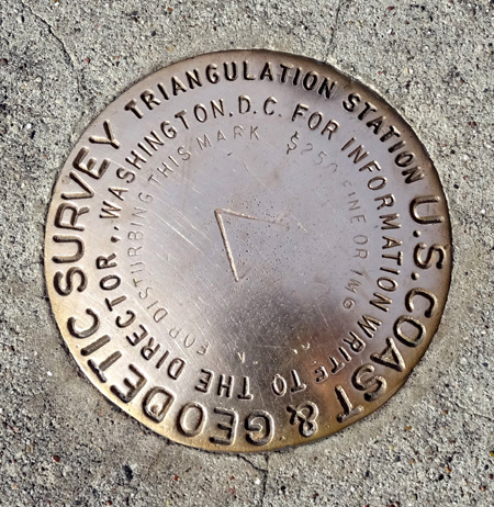
Jim (above) looks at the survey
marker (below) on the walkway at the NV-AZ border line.
Jim took my picture there,
too.
View of Lake Mead to the north
from the center of the dam
If you look at the diagram of the dam, you can see that
both NV and AZ have two intake towers protruding out into Lake Mead.
Both states have a large clock with the time -- an hour apart. The state line here is also the
dividing line between the Mountain and Pacific time zone.
That must get confusing for workers and some visitors!
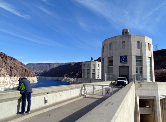
Jim looks down to the lake on the
walkway toward the AZ intake towers.
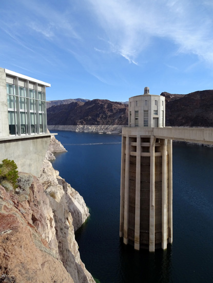
The outer Nevada intake tower
(R) and Spillway House (L)
PERSPECTIVE OF THE DAM FROM MEMORIAL BRIDGE
As we drove back up to US 93 we stopped at the parking area for the
bridge overlook. Exhibits on the plaza and at the top of the ramp
explain how the Memorial Bridge was constructed.
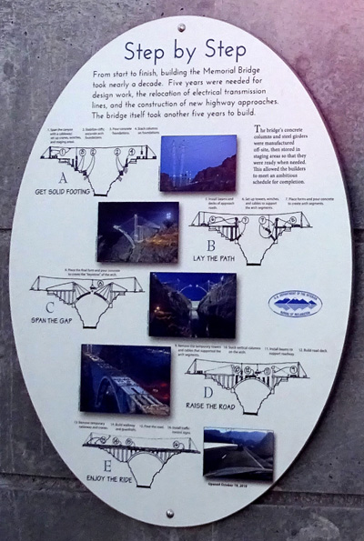
On this sign, we learned that it took a decade to design and build
the bridge, which opened up to traffic in 2005. Five years were needed for
design work, relocation of electrical transmission lines, and
construction of new highway approaches. It took another five years to
build the bridge itself.
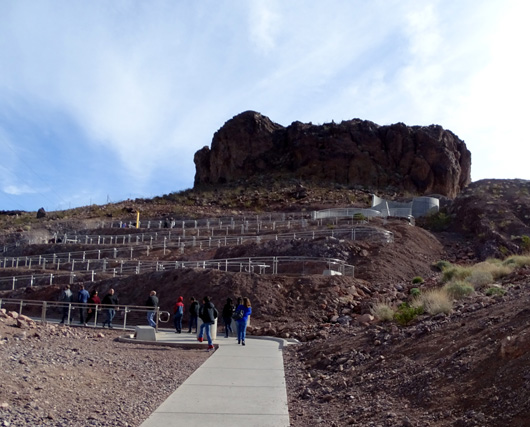
Ramps allow visitors who can't
use the stairs to access the bridge walkway.
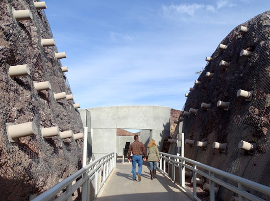
Sample rock cores removed for
analysis by engineers before construction
of the bridge are displayed along
the path before you enter the upper plaza.
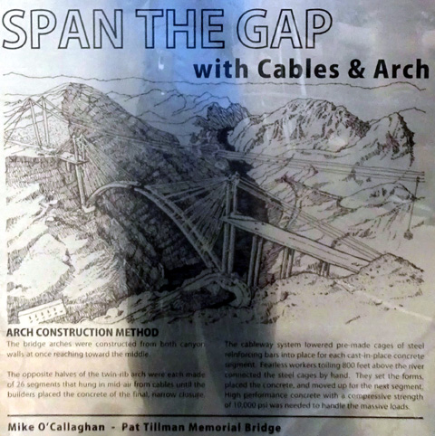
This is called a deck arch
bridge. It's a unique hybrid structure to span this deep canyon,
designed with enough strength to
withstand potential earthquakes and high winds.
Here's another picture of the bridge, as seen from
the top of the dam.
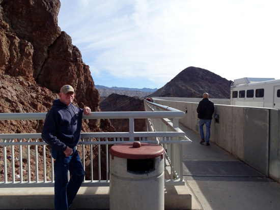
Jim waits at the entrance to the walkway across the
bridge. Traffic on US 93 whizzed by at 65 MPH
or more on the other side of the concrete barrier
but we were busy admiring the dam and felt safe.
We walked out and back to the middle of the bridge, down to the truck,
and returned to Nellis AFB on the route along Lake Mead. I'll show more photos
of the lake in the next entry.
Next entry: scenes from two trips in the Lake Mead National
Recreation Area
Happy trails,
Sue
"Runtrails & Company" - Sue Norwood, Jim O'Neil,
Casey-Girl, and Holly-Pup
Previous
Next
© 2019 Sue Norwood and Jim O'Neil