Continued from the previous page.
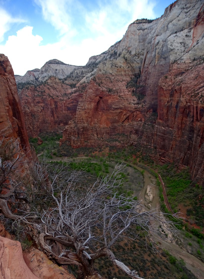
SCOUT'S LOOKOUT
At this small plateau, which I keep calling Scout's Landing by
mistake, the West Rim Trail turns toward the left and continues climbing
higher for another 16 miles to Lava Point in the northwest part of the park.
The Angels Landing spur trail goes right a couple hundred feet toward
the base of the steep spine that hikers take to the highest point on
Angels Landing at 5,790 feet:
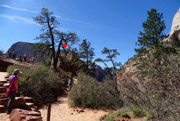
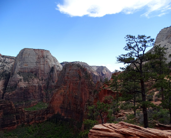
Angels Landing (red dot) is
behind the trees in this picture as we just reached Scout's Lookout.
Above and below: Looking east
toward the base of Angels Landing
Looking the other direction, up the West Rim Trail;
narrow Refrigerator Canyon is
to the left, and deep Zion Canyon to the right.
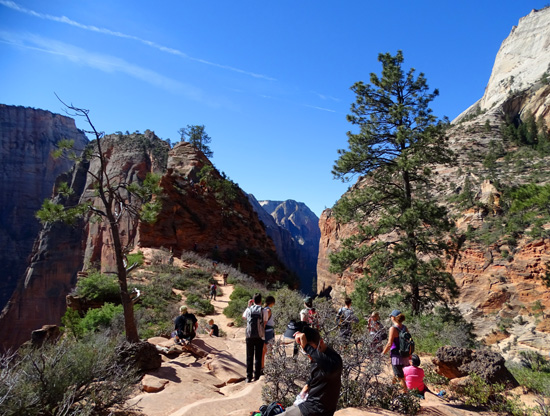
This rocky plateau is a fine destination in itself for people
who are afraid of heights, are clumsy, don't have young knees, are not
in good physical conditions, are under about age 12, are in a hurry, or
simply don't want to fight the crowds on the final exposed section of trail.
It's a safer place to "land" than up on Angels Landing!
If you walk around to different viewpoints
on the plateau, Scout's Lookout is a good place to see some impressive
views down into Zion Canyon:
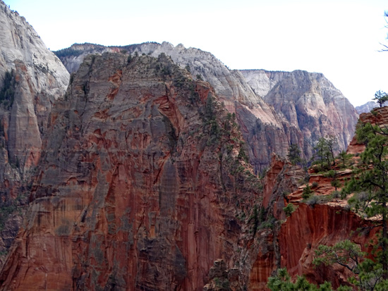
Morning view southeast to the Big Bend
overlook along the Virgin River;
the thin rock fin jutting out from the
right is called The Organ.
I was able to get more detail of
Big Bend and The Organ in the afternoon when the light was more even.
View north into Zion Canyon
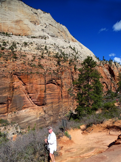
Although there were a fair number of people going up the trail with
us to Scout's Lookout they weren't a big problem because the path is
mostly paved and wide enough for passing slower hikers or meeting people
going back down.
The "trail" -- I use the term
very loosely -- up to Angels Landing is
another issue entirely. First, let me describe it.
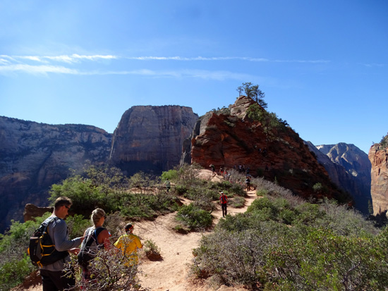
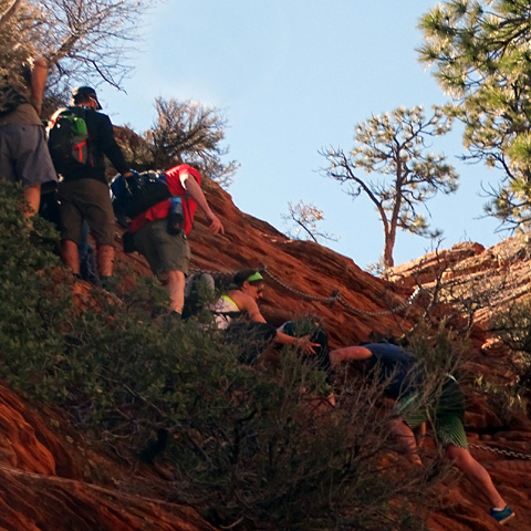
A DEVIL OF A TIME REACHING ANGELS LANDING
One half mile in distance. 500 feet elevation gain (that's very
steep in such a short distance). Scrambling required over slick,
sometimes chiseled, rocks and boulders. An extremely
narrow route in most places, with two-way traffic using the same set of
posts and chains to keep from sliding off the cliff . . .
Did I mention the sharp drop-offs into Refrigerator Canyon on one
side, or to the valley floor 1,500 feet below on the other??
People have died falling off this cliff -- half
a dozen from 2006-2016, according to this sign at the base of the approach:
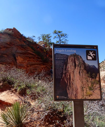
Unfortunately, two more people died
up here in 2017 and 2018, bringing the
total number of deaths to 15
since Angels Landing Trail first opened to the public.
If any of that intimidates you, you probably shouldn't attempt the
rest of this hike.
SHOULD WE OR SHOULDN'T WE??
Jim and I had different -- and unpredictable -- reactions when we got
to this point.
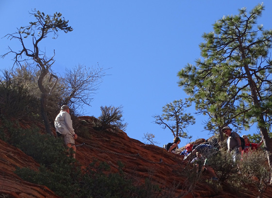
Since I'm better trained for hiking and climbing mountains than he is, I figured
I'd be the one to go on up the steep trail. But when I saw how long it was taking
people to scramble up and down the boulders and slickrock on just the lower, tamer
bottom part of the climb,
and just how incredibly steep it is from a different perspective (next
photo) and from looking at photos online,
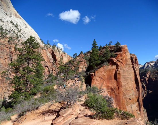
View from a little farther up the West Rim Trail
I decided that even though I could probably make it up to the landing OK,
my knees would really hurt coming back down. So I opted out.
As we were standing there watching people in the lower section of the climb,
Jim -- who isn't very well trained hiking right now and who initially thought
he'd be happy just to make it to Scout's Lookout -- suddenly decided,
"I'm going up!"
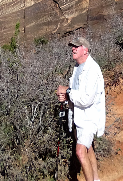
"I think I can, I think I can . . ."
It was just too tempting. You can almost see the wheels turning in his head in the
close-up above.
I said, "OK, I'll wander around this lower landing
and wait for you to come back down. Have fun and be careful!!"
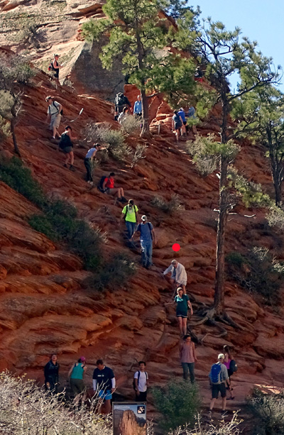
Jim had to wait a few minutes for hikers who were coming down, then slowly began making
his way up the steep lower slope, using the chains as needed:
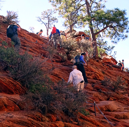
Jim's in the white shirt; I marked him with
a red dot in two pictures farther down this page.
Jim waits patiently to use the rope so he can
procede.
He made it a couple hundred feet up but turned around in frustration because it was
taking so long to make any progress with all the two-way traffic needing to use the
same one chain for most of the route.
He knew the trail was even more narrow higher up, with no other
options except to follow the chains. I "borrowed" the
next picture
from a Google search for photos higher up Angels Landing to give
you an example of what I mean:
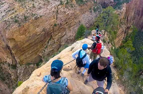
About a 1500-foot drop on either side: left
is Refrigerator Canyon, right is Zion Canyon.
Anyone hiking up to the landing has got to be very patient and courteous.
MAYBE LATER?
There were some older people on this difficult part of the trail, not
just younger ones. That was encouraging to us.
If we ever go up there, we'll need a much earlier start even in the spring or fall,
and new knees would be nice! The 360-degree views from Angels Landing are reported
to be outstanding so I'm a little disappointed we didn't get to experience that today.
[Addendum in 2018: Now that Jim and I have three new knees between us,
I think we could both do Angels Landing if there were fewer people
around. Since having a partial knee replacement in late
2016, Jim has started walking a lot more, even training for a 100-mile
event later this
summer. And I no longer have any knee pain either, after two total knee replacements
in late 2017. We still can't run -- not good for the implants -- but our
orthopedist says we can walk and hike and climb up mountains as much as we want,
even ultra distances. Yay!!]
Besides our unexpected reactions upon seeing the beginning of the Angels Landing
Trail, two other things surprised me about it:
One, I didn't see any rangers at Scout's Lookout or the base of the ascent either time
I was on the lower landing today. Maybe someone was there and I just didn't see him
or her. Seems like it would be a good thing to have one or more rangers
there to answer questions, advise people about the difficulty of this trail, and
maybe prevent some mishaps.
For example, while Jim was climbing the lower section I watched a young couple
coming down with a little boy about seven years of age (next picture). His parents had
to help him every step of the way, slowing everyone else who wanted the chains and the
best route. The little boy was crying, clearly scared and unhappy. That's
much too young of a child to be taking on such a dangerous trail.
Two, there are apparently no restrictions on how many people are permitted to climb
up to Angels Landing from the base at Scout's Lookout.
I haven't read anything in the Zion park information about permits to avoid congestion
on this trail. I know that the Angels Landing Trail is even more crowded in the summer
months than it was today. I can't imagine how long it would take to safely get up
to the landing and back down when there are even more people on the trail than
there were today.
I waited 25 minutes for Jim to come back down. Because of all the people it took him
that long to go only a couple hundred feet up and back down. The trail is
half a mile up to the top and gets extremely narrow and more
gnarly than where he was scrambling.
How long would that have taken him today??
When Jim got back down to Scout's Overlook he decided he'd turn around and go back
down the trail we'd just come up. That was a tough enough 5+ miles for him since he
wants to have the leg strength to enjoy a long bike ride tomorrow. He took the shuttle
back to the visitor center, then walked 3/4 mile to the campground. Including dog walks,
he had a total of seven miles of walking today, the most he's done in a good while.
To see professional photos of the last part of the Angels Landing Trail
that we didn't hike, and the views from the
top, check out the beautiful copyrighted pictures on Joe Braun's
site. He has several pages of photos of each
trail at Zion. There are plenty of other hikers' pictures of the Angel
Landings Trail if you do an internet
search for them.
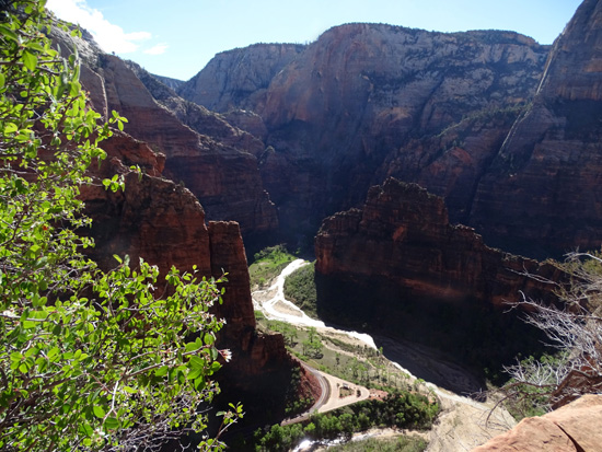
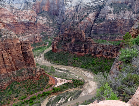
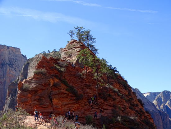
ANGELS LANDING FROM ABOVE
I continued hiking north on the West Rim Trail for more than three more miles before
turning around this afternoon and returning the same way past Angels Landing to The Grotto, for a
total of 11+ miles on trails and a couple more in town.
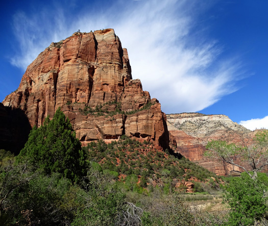
There are good views up to the Angels Landing "fin" formation from the
south, such as this one from the West Rim Trail down in Zion Canyon:
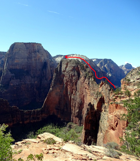
Views of the other side of the formation from trails and cliffs at higher elevations
to the north give a different perspective and show the route of the steep path to the
top of Angels Landing -- looking down at it.
The easiest high viewpoints to reach are another quarter to half mile up the West Rim
Trail. You can see parts of the steep approach trail to the Landing from there (and the tiny
people climbing it), as well as the whole length of the very narrow plateau on top.
The next pictures are from both this morning and afternoon as I went
farther out and back on the West Rim Trail:
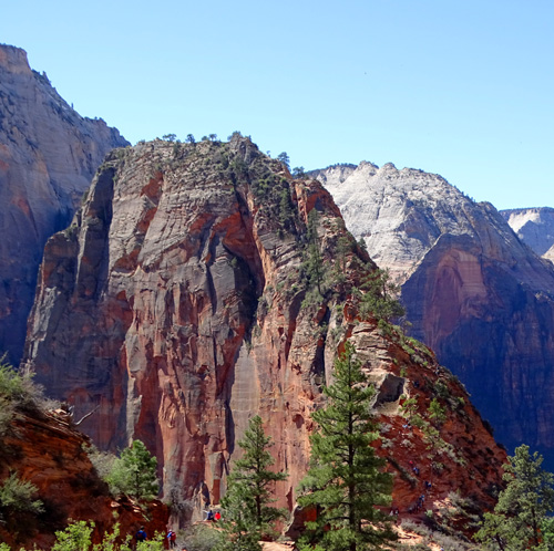
The Great White Throne, behind Angels
Landing and to the left,
shows up better in the afternoon (below) than in the morning (above)
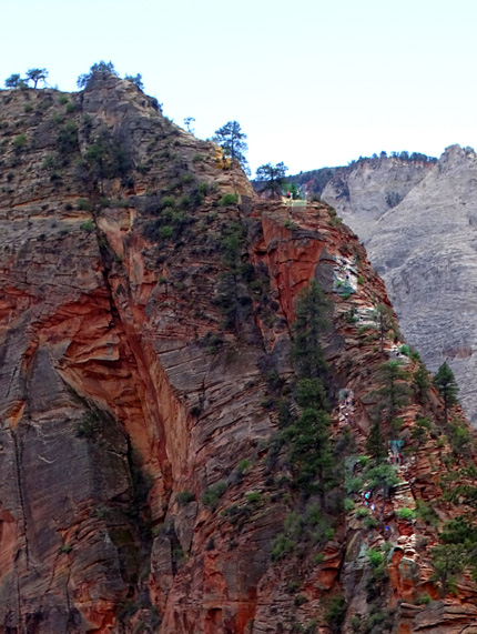
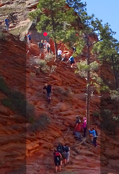
I highlighted some of the hikers in this near-vertical section
near the top.
Another great vantage point on the east rim is even higher than these
views from the west rim, but it's farther away from Angels Landing --
Observation Point, on the trail of the same name.
Here's the map section I showed on the first page of this entry
with the trail up to Angels Landing marked in yellow:
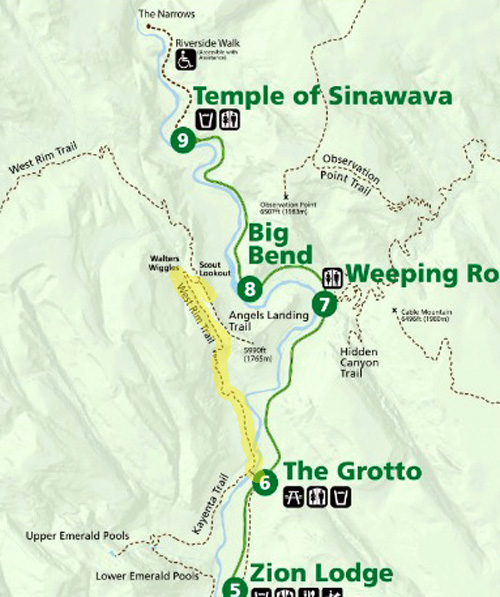
On the map (if your screen is large enough) you can see the Observation Point Trail
on the east rim of Zion Canyon. It starts at Weeping Rock and heads mostly north for
four miles. Observation Point is right above the "g" in Big Bend on the map.
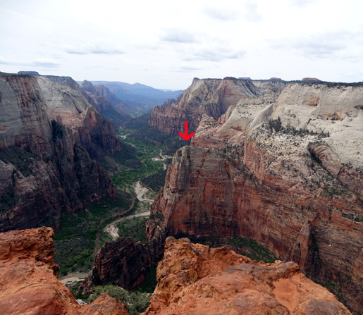
The point at the end of the trail gives an amazing and very long view of the main
canyon to the south, including a look down over 500 feet in elevation to
Angels Landing, which I marked with a red arrow:
I hiked Observation Point Trail
later this week and pronounced it my very
favorite of all the trails I hiked in Zion National Park this week.
I showed some pictures in this entry of the descent from Scout's Overlook back
to The Grotto on the West Rim Trail. The next entry will include pictures from
the whole 5+ miles I hiked up (and back down) that trail today.
Next entry: scenes from the lower 5+ miles of the West Rim Trail
from The Grotto to Cabin Spring (the best part of this 14-mile-long,
point-to-point trail per one backpacker I met who has hiked the whole thing)
Happy trails,
Sue
"Runtrails & Company" - Sue Norwood, Jim O'Neil,
Cody the ultra Lab, and Casey-pup
Previous
Next
© 2016 Sue Norwood and Jim O'Neil
