We are grateful for each great weather day we have this week so we
can hike, cycle, and sight-see as much as possible in Zion National Park.
Today was no exception -- bright blue sky with puffy
white clouds, temps in the low 70s F. by afternoon, no wind, low
humidity -- just right for a somewhat strenuous hike on a
potentially perilous path!
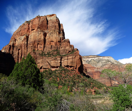
Angels Landing is perfectly
highlighted by the wispy clouds behind it. Any angels up
there??
In recent years neither Jim nor I have been able to run because of our bum
knees.
Visco-supplementation with gels like Orthovisc and Synvisc that
are injected into both of my arthritic knees allow me to hike all day
and climb steep and/or high mountain trails. I much prefer that to cycling. Jim messed up
one of his knees in a bike wreck several years ago and hasn't been able
to tolerate even walking more than a few miles. He much prefers cycling to hiking now.
This morning, however, Jim decided he was game to attempt the Angels
Landing hike. We've read about it and have talked to several people, including some
teenage siblings at Red Canyon last fall, who've raved about its magnificence -- and
fear factor! -- so we had to see what all the hype is about.
Today's weather was perfect for it. Unfortunately, a lot of other
people thought so, too.
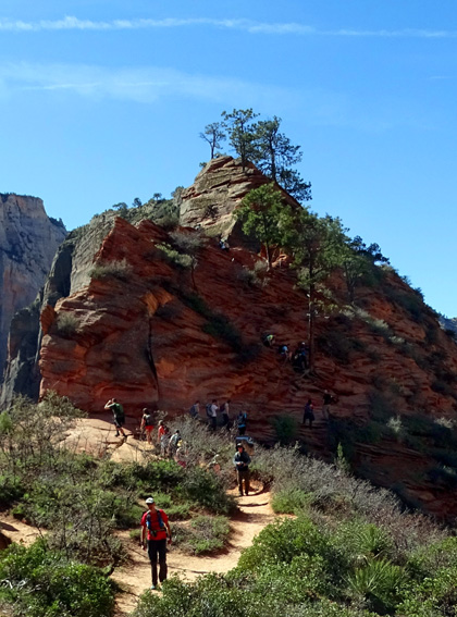
Lots of folks coming and going at
the base of the last climb to Angels Landing
Angels Landing is one of two truly iconic hikes in Zion National Park.
The other one, The Narrows, is closed this week to hiking because
recent rain and snowmelt have made the North Fork of the Virgin River through the Zion
slot canyons too high, fast, and muddy to safely negotiate. Because of
that, the Angels Landing trail was probably busier today than it would
have been otherwise.
TODAY'S HIKE
Note: Photos in this entry are from both this morning as
Jim and I climbed up toward Angels Landing, and this afternoon when I came back
down alone after going another 3+ miles past Angels Landing. I got better pictures in the
mid-afternoon when the sun was higher and fewer features were in the
shade in Zion Canyon. Many of the photos are from this afternoon.
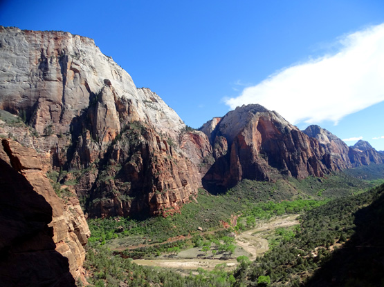
Mid-afternoon shot of the eastern
rim from the West Rim Trail;
in the morning, the east rim is all in the shade.
We should have gotten an earlier start this morning. We didn't get on
a shuttle bus at the visitor center until 9 AM and didn't arrive at the
Grotto bus stop for the trailhead until about 9:30.
That was just too late to avoid the masses who wanted to experience
this unique trail for themselves.
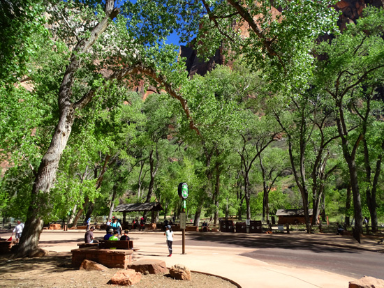
Grotto bus stop in the afternoon
Here is a map section of the Angels Landing route from the
Park Service's website (there's a
better one on Joe Braun's website but it's copyrighted):
Most of the route is up and back down the West Rim Trail, which I'll
feature in the next entry. (Today I continued on the West Rim Trail for
another 3.5 miles to the northwest before turning around.)
After negotiating all the switchbacks on the West Rim Trail from the river up to Scout's
Lookout, the real Angels Landing spur trail begins up the narrow, rocky
fin that juts out into Zion Canyon.
It's about two miles from shuttle bus
stop #6 at The Grotto to the base of Scout's Lookout, then another half
mile to the final viewpoint on Angels Landing. Total distance out and
back is about five miles.
THE ASCENT
The route to Angels Landing is rated strenuous by the Park Service.
They aren't kidding. The final climb requires more scrambling than any
of the seven 14ers I've hiked in Colorado!
The first two miles are less strenuous than the last half mile but
they are difficult enough for many people to call it a day at Scout's
Lookout, without attempting the extremely steep, narrow, gnarly final
route to the top of Angels Landing using chains attached to posts to
guide them.
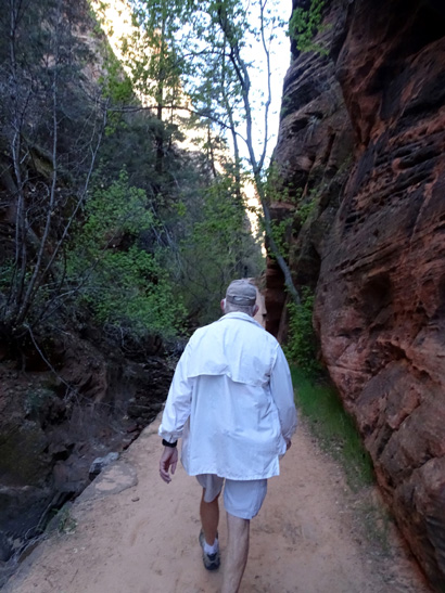
It all starts off innocently enough. Hikers first walk across
Zion Canyon Scenic Drive at about 4,100 feet elevation, then cross the river
on a pedestrian bridge:
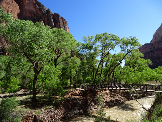
Just across the river the trail splits. The Kayenta Trail heads south
to the Upper and Lower Emerald Pools (
tomorrow's hike). To get to Angels
Landing, hikers turn right and go north on the West Rim Trail.
The ascent starts off gradually in the first half mile
as the paved trail rises gently above the west side of the Virgin River.
There are some excellent views of the south side of Angels Landing from
this perspective, and Zion Canyon to the north:
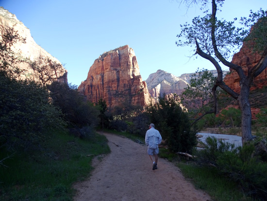
Jim walks along the river in the
morning; Angels Landing is straight ahead.
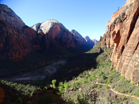
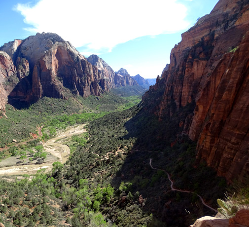
I took the picture above looking
north through the canyon to Angels Landing
in mid-morning, when there was
still a lot of shade. I prefer the more
colorful mid-afternoon shot
(below) from about the same angle.

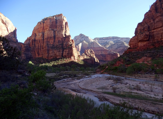
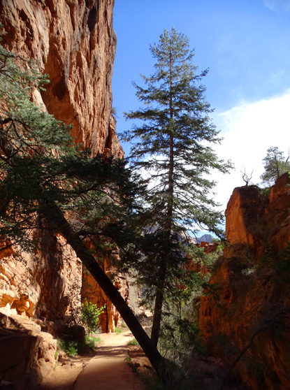
After this relatively flat section by the river the trail ascends
gradually through shrubs and trees to several long switchbacks beneath a high, colorful
sandstone wall. This mile-long section goes up to a narrow "hanging"
canyon with a little creek.
Morning shot showing the winding
trail ascending toward the first set of long switchbacks
Afternoon shot from a little
higher up the cliff
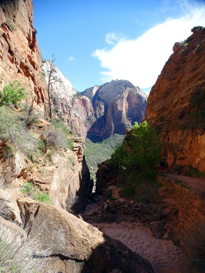
The views down to Zion Canyon from the long switchbacks are
interesting if you stop to look for a little while -- the long
line of colorful cliffs standing guard on the eastern side of the canyon;
the winding Virgin River with numerous sand bars exposed; bright
green spring leaves on the Fremont cottonwood trees close to the river
morphing to darker green Utah junipers and pinyon pines at the base of
the rock walls; little white shuttle buses moving visitors slowly
along Zion Canyon Scenic Drive; and tiny people below you making
their way up and down the switchbacks on the trail.
I was able to get the best photos when I was coming back down the path
in the afternoon. Not only is it easier to see the trail looking down,
but there were also fewer shadows then.
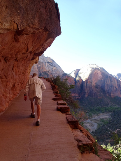
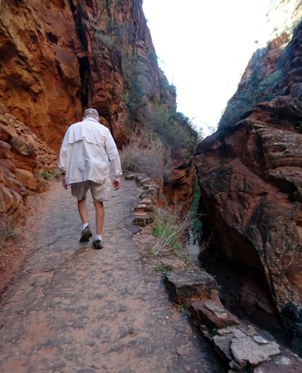
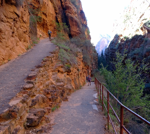
Jim trudges up the switchbacks
beneath an overhang;
the Virgin River is several hundred feet below us now.
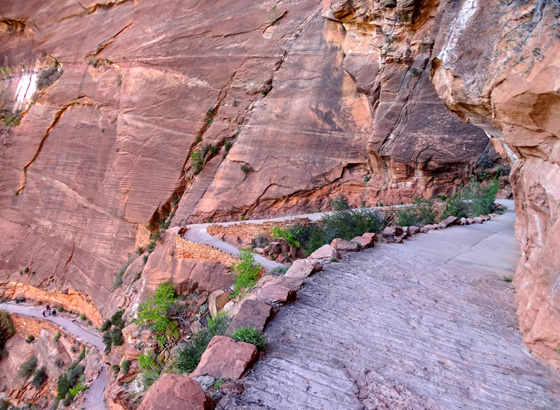
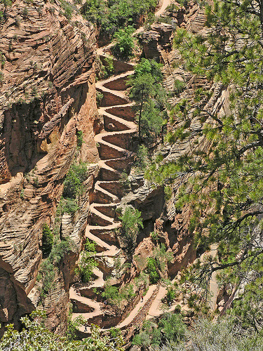
View from the switchbacks as I
hiked back down in the afternoon; the concrete
on the path that was carved out from the cliff
is scored to increase traction.
This view of the switchbacks may
make you dizzy!
See the tiny people way down below?
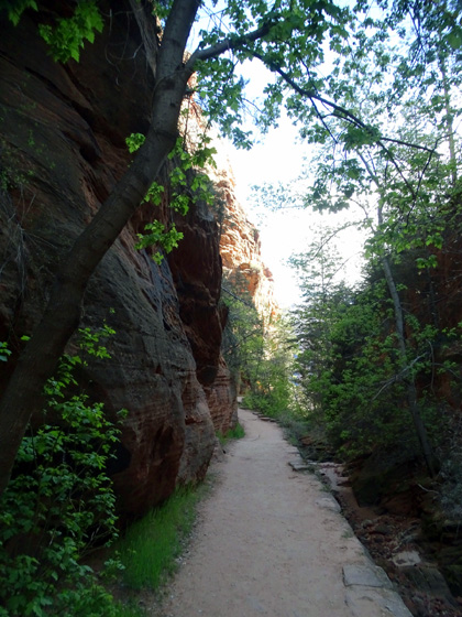
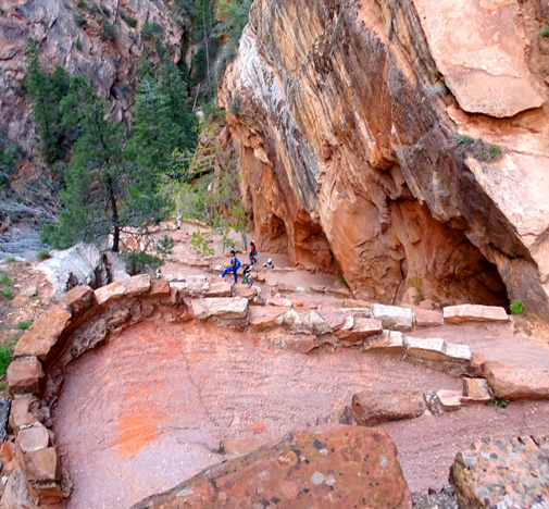
At the top of this section of switchbacks the trail enters a side canyon
that is difficult to see from down below because it is so narrow.
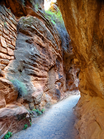
REFRIGERATOR CANYON
It was also difficult
for me to get good pictures for about a quarter mile through this
canyon because of all the shade, even in mid-afternoon
when the sun was higher. It's aptly named "Refrigerator Canyon"
because it's noticeably cooler than the more exposed parts of the West
Rim Trail. It would be a nice respite from the heat in the summer.
Here are a couple pictures I took on our ascent in the morning:
I got these shots coming down through the slot canyon in the afternoon:
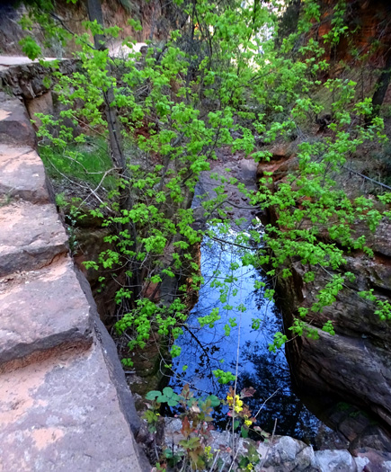
The pathway through Refrigerator Canyon is above a little seasonal stream.
Today the creek had some water
in it but I'd guess it's probably dry when it hasn't been raining for a while.
Part way up the slot canyon on the ascent you'll come to . . .
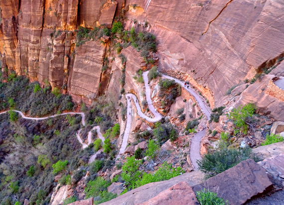
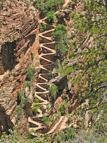
WALTER'S WIGGLES
Walter's what??
The Wiggles, engineered and constructed by the CCC in the 1930s, is a
set of about ten tight switchbacks that are reinforced
with rock "bricks" to help hikers gain several hundred feet of
elevation through Refrigerator Canyon before they arrive at Scout's Lookout.
Here is a photo I borrowed from this
link on the internet that shows all but
the lower couple of switchbacks. I don't know who
to give the photo credit to:
From what I've read, you have to have a powerful zoom
lens and be a real Houdini to get into position from higher up on the West Rim Trail
above the head of Refrigerator Canyon to get that shot of the entire series of switchbacks.
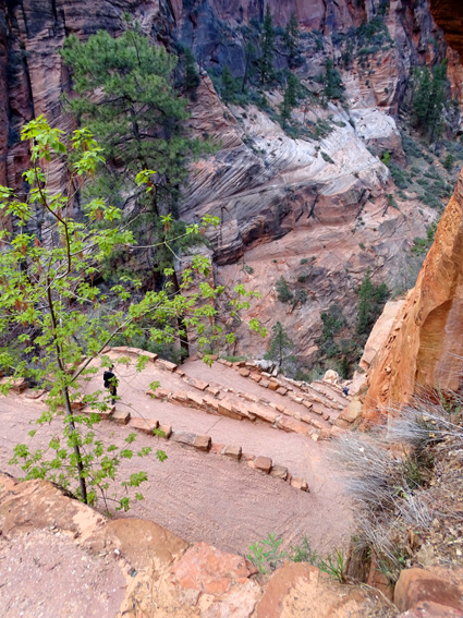
This part of the West Rim Trail is a lot of fun, especially coming back down.
On the way up you may wonder if you'll ever come to the end of these switchbacks.
They go on and on and on as you walk up and up and up, as you can see from the picture of
the whole series of them. At least they are fairly gradual and not steep.
Above and below: These picture
are near the beginning (low end) of the Wiggles.
It's a good thing that it's harder to see the people up ahead of you on the ascent
than the descent so you can't see how far you have to go:
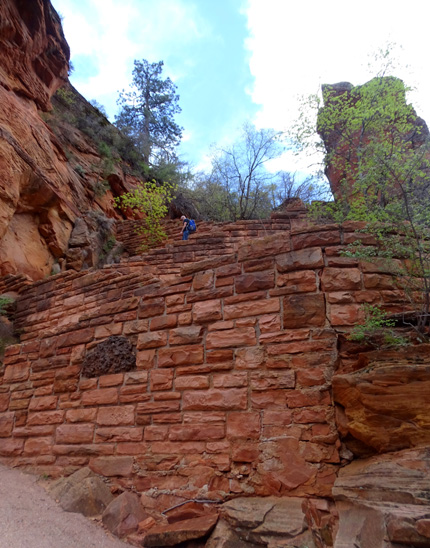
It's a lot easier to see the switchbacks on the way back down:
At the top of Walter's Wiggles, you can breathe deeply and take in the
magnificent views from the little plateau called Scout's Lookout. It
sits at the base of the steep final ascent to Angels Landing.
The elevation gain so far has been about 1,100 feet in
two miles, from about 4,200 feet at The Grotto on my GPS to 5,354 feet
at Scout's Lookout. None of it is really steep to this point but we felt it in our quads
on the way back down.
Continued on the next page . . .
Happy trails,
Sue
"Runtrails & Company" - Sue Norwood, Jim O'Neil,
Cody the ultra Lab, and Casey-pup
Previous
Next
© 2016 Sue Norwood and Jim O'Neil
