Even though both Jim and I have been to Bryce Canyon previously, it
had been decades -- at least 30 years for Jim, and my most
recent park brochure was dated 1996.
So on our first evening in the vicinity, we drove from our campground
in Red Canyon to do a quick look-see of the park from some of the
overlooks as the sun was setting. It's a fairly short drive of 17 miles
to the entrance; the park road continues another 18 miles from
north to south along the Paunsaugunt Plateau and the cliffs overlooking the
magnificent rock formations in the linear canyon:
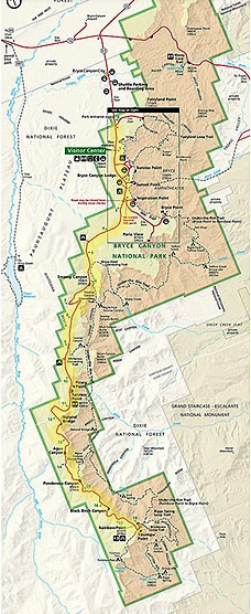
That tiny map just shows the general layout of the park. I highlighted
the main park road in yellow. You can enlarge this map so you can
actually read it -- and see a more detailed map of the entrance
area -- at this
park link.
Bryce is definitely mesmerizing and I spent as much time hiking and
sight-seeing there as possible during our month-long stay in the area
this fall. We like the area so much we returned
again for a month in May, 2016 and even longer during autumn, 2016.
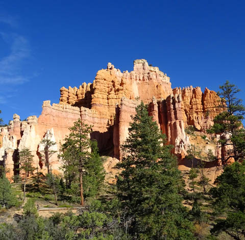
The cliffs and rock formations in each place we've visited in
southern Utah's canyon country have been unique. The geology of Bryce
Canyon is similar to that of Red Canyon but the multi-hued rock formations
at Bryce are more pastel than vivid and the scale is much grander. I
like both canyons for different reasons.
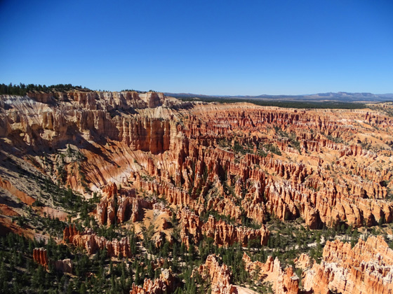
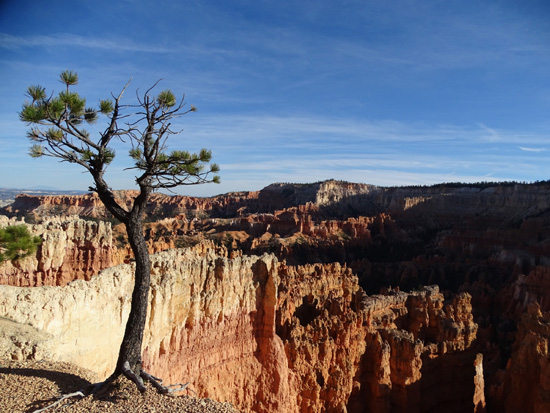
Looking north from Bryce Point
into the large Bryce Amphitheater
This entry and the next one are overviews with lots of general
information about visiting Bryce Canyon National Park. They include
photos I took during September and October from
the overlooks, Rim Trail, visitor center, lodge, and new multi-use path.
I'll have additional entries with lots more pictures from the trails down
into the canyon. I hiked most of the 65 miles of trail in the park
during this visit and we both took a half day horse ride through the
heart of the amphitheater.
VISITING BRYCE CANYON
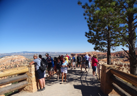
This fall has been warmer than average and the crowds at Bryce Canyon
haven't abated much since the busy summer season, per rangers I've
talked with.
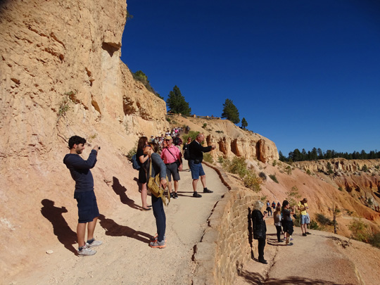
Lots of folks on the Navajo Trail
as it switchbacks down from the rim
Bryce doesn't get as
many visitors as Zion National Park, located less than a two-hour drive
to the southwest, but the volume of traffic, packed
parking areas, and number of people at the visitor center, lodge, and
overlooks at Bryce from September 17 to October 17 took us by surprise.
By the end of 2015 the official visitor count at Bryce was 1.7
million people. Most of them come to the park in the six months from May
to October. Do the math . . .
It was even worse (for visitors, not the National Park Service!) in 2016,
the centennial celebration of the NPS. Yes, I do realize that Jim
and I added to the crowd both years.
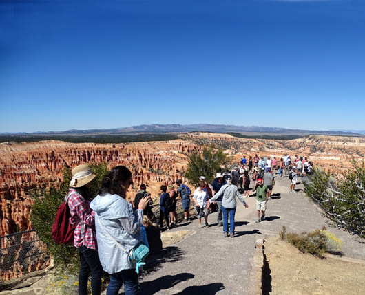
Visitors at the Bryce Point
Overlook in late September, 2015
Bryce Canyon is open all year long, although not all the trails and
services are open during the colder winter months. Photos of snow on the colorful
rocks are beautiful so even a winter visit is spectacular.
Fall is a popular time for retirees and foreigners to visit the park.
We didn't see very many school-age kids during our current visit. We did
hear many different languages and saw numerous large tour buses bringing
folks from all over the world to see Bryce Canyon for a few hours.
Visitors enjoy the views in three
directions into the canyon at Sunset Point Overlook.
It is possible to see down into the canyon all along the
plateau rim for 18 miles in several hours, as long as you can find
parking spots at the busy overlooks above the main amphitheater near the
park entrance.
To get a real feel for the majesty of the hoodoos and other rock
formations, however, you need to allow time to hike down into the canyon
on one or more trails. As in Red Canyon, the more time you can spend
here, the more you'll appreciate how special a place it is.
Pretty sherbet-colored "castle"
on the Fairyland Trail
Check the park
website, brochure, and newspaper guide
for the park map, entry fees, and dates/hours of operation for the
campgrounds, lodge, cabins, shuttle buses, etc.
We got in free because we have National Park Service senior passes.
Shuttle buses are free to everyone if you want to use them (we never
did). The exhibits and park video in the visitor center, interpretive
talks, and ranger-led hikes are also free. You'll have to pay for food,
gifts, camping, lodging, guided horseback tours, etc.
GETTING AROUND THE PARK
During the spring, summer, and fall free shuttle buses operate from
Bryce Canyon City a couple miles from the park entrance. Buses run through the
first three miles of the park where the most popular overlooks and
facilities are located.
The buses don't operate on what they call the Southern Scenic Drive
between Bryce Point and Rainbow/Yovimpa
Points in the southern part of the park, however. You have to provide
your own transportation to reach those overlooks.
Unlike Zion National Park, visitors can still drive their own
vehicles along the entire 18-mile park road. Just beware that popular parking
areas fill up by mid-morning, even on rare rainy days.
Because of the crowds I quickly learned I needed to get to trailhead
parking areas at Fairyland, Sunrise, Sunset, Inspiration, or Bryce
Points before 8 AM to be assured of finding a parking place. No one was
manning the entrance gates before 8, to my surprise. The longest lines
at the gate seemed to be from 9-11 AM, when vehicles could be backed up
for half a mile to get in. By mid-afternoon it was usually easier to get
a parking spot anywhere in the park.
PARK HAZARDS
Elevations in the park range from about 6,600 feet at the lowest
point in the canyon to 9,100+ feet at Rainbow Point. It's about 8,000
feet elevation at the popular overlooks near the entrance.
Most visitors aren't used to these high desert elevations so pace
yourself when hiking. Remember that if you go down any of the trails
. . . you have to come back up!
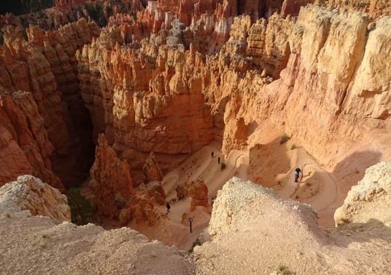
Looking down the upper
switchbacks on the Navajo Loop Trail,
the steepest but most popular trail in the park
Weather is also a potential threat. There are frequent summer
thunderstorms and from spring to fall there can be variations of 40
degrees Fahrenheit or more from morning to afternoon. Half the year it
gets below freezing at night. (All this freezing and thawing exacerbates
the process of eroding the rocks.)
Another hazard in the park is all the steep cliffs. The Rim Trail
goes quite close to many steep drop-offs so be careful walking there.
It's a long way down if you slip
over the edge of the rim! This spot is near Sunset Point.
Pets are allowed at overlooks, in the two campgrounds, and on paved
roads and trails (all of the bike path, and the Rim Trail between Sunrise and
Sunset Points) but not on any unpaved trail or in buildings unless they
are service dogs. That's standard for most U.S. national parks.
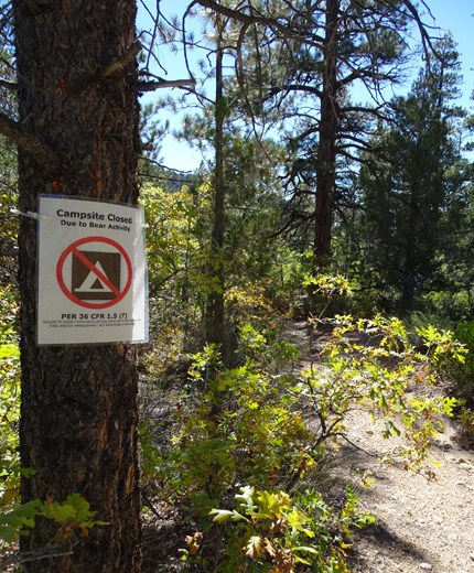
Wild critters aren't too much of a problem at Bryce Canyon, although
I saw warnings about a mountain lion spotted near the North Campground
and a back-country campsite down in the canyon closed due to black bear
activity:
It's easy to spot birds, mule deer, pronghorn, chipmunks, and ground
squirrels on the rim and canyon trails. I didn't see any of the resident
rattlesnakes, even on warm, sunny afternoons down in the wilderness part
of the canyon.
In the fall visitors can enjoy yellow aspen leaves and orange/red oak
leaves on shrubs. Pinion pine and juniper grow among the hoodoos at the
lower elevations. Ponderosa pine, bristlecone pine, fir, and aspen
thrive at higher elevations in the park. Some colorful wildflowers were
still in bloom during this visit, including yellow rabbitbrush and
purple asters.
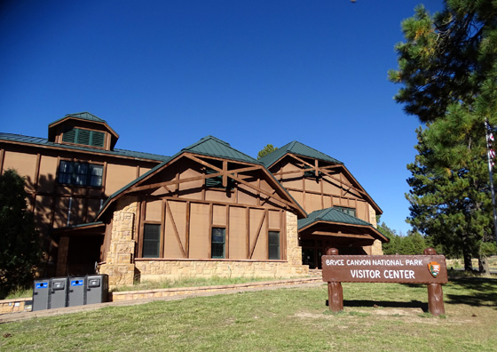
BRYCE CANYON VISITOR CENTER
If you've never been to a particular national park recently it's a good idea
to stop in the visitor center upon your arrival. Bryce's visitor center
is located right inside the entrance gate.
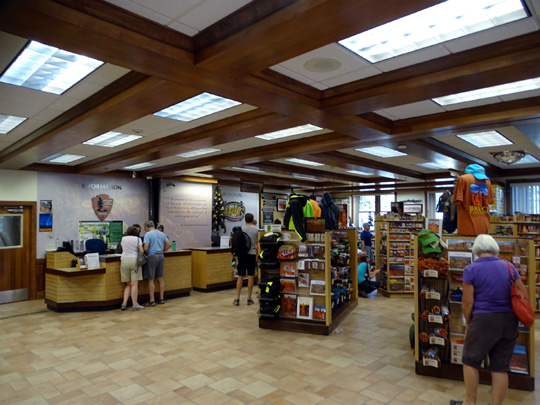
You can get a park brochure and "The Hoodoo" newspaper guide at the
entrance but there is much more information available in the visitor
center -- rangers can answer questions and offer advice, you can
watch the park video in the theater, you can see when ranger talks and
walks are scheduled, you can browse the exhibits and items for sale,
etc.
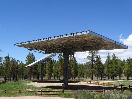
You can also observe the two new, very large solar arrays behind the visitor
center and read how the Concentrating Solar Photovoltaic system will power
most of the visitor center's and headquarters building's electrical
consumption:
There is also a general store located in the extended parking area
near Sunrise Point where visitors can purchase food items, ice, camping
supplies, clothing, books, calendars, and various gifts.
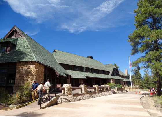
BRYCE CANYON LODGE
The Bryce Canyon Lodge is open late March to early November and
includes a restaurant, meeting room, cabin, suites, and gift shop. We
signed up there for our horseback ride and ate a tasty lunch in the
dining room after that ride.
Entrance to the lodge
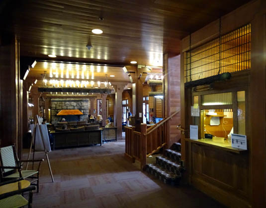
Part of the lobby
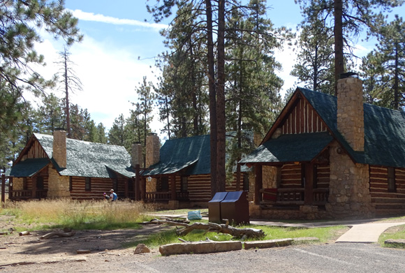
Handsome cabins near the lodge
This is one of the national park lodges designed by architect Gilbert
Stanley Underwood. It was built in 1923, a decade before the CCC began
constructing buildings at national parks, and is a National Historic
Landmark. At Bryce Canyon Underwood designed buildings with a unique
wavy pattern in the rooftops.
SHARED USE PATH
A very nice paved 6.2-mile shared use path from Bryce Canyon City to
Inspiration Point was still a work in progress when we visited this
fall. The path was graded but not all paved or landscaped.
It connects to the bike path that starts at the lower end of Red
Canyon and runs 15+ miles to Bryce Canyon City north of the park, giving
runners, hikers, and cyclists 22+ miles of trail or up to 45 miles out
and back.
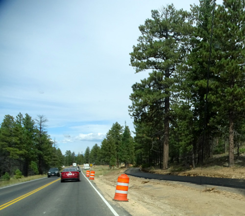
Newly paved section of the bike
path in the park;
most of its six miles in the park
are farther from the road than this.
Jim was able to ride on the packed dirt over the part of the trail on
Paunsaugunt Plateau and in the park that wasn't finished yet. He just
got out on the road when crews were actually working on them.
All the paving was done when we were here in May, 2016 so we both
rode on the path. Crews were still doing some striping and landscaping
here and there. By fall of 2016 the path was totally completed --
we love it! I'll show more photos in the 2016 journal.
Introduction continued in the next entry: scenes from
the overlooks and Rim Trail
Happy trails,
Sue
"Runtrails & Company" - Sue Norwood, Jim O'Neil,
Cody the ultra Lab, and Casey-pup
Previous
Next
© 2015 Sue Norwood and Jim O'Neil
