One afternoon earlier this week
we took a scenic drive up the coast north of Jacksonville/Mayport to
Fernandina Beach and back. We wanted to sight-see and determine if there
were any good bike paths for Jim to ride.
The fastest, shortest route from the Mayport Naval Station is to take
the HMS Global Marine ferry across the St. Johns River from Mayport to
Fort George Island. This is the northern end of the Scenic and Historic
Coastal Highway (A1A) along the coast.
I marked the ferry
route on the map section below with an arrow. The black lines are the
first part of the route we took from the campground at the naval station:
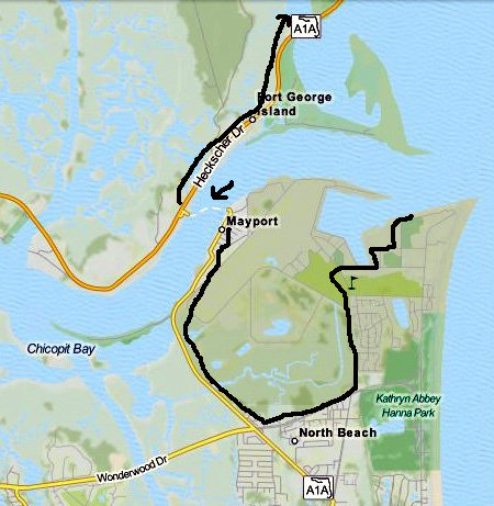
The only other driving alternative to get from the south section of AIA
to the north section is to drive west to I-95, cross the river, and go
back east on FL 105. That route is 28 miles longer -- each
direction -- than
taking the ferry.
It was worth $6 each way (vehicles 20 feet and
less) for us to take the ferry.
Even with a bit of a wait to get on the ferry we saved time, gas, and
driving hassles.
Besides, it's fun to
ride the ferry! I might not think so if I had to do it to get to work
every day but for us, it was a treat. We haven't been on a ferry for
about ten years.
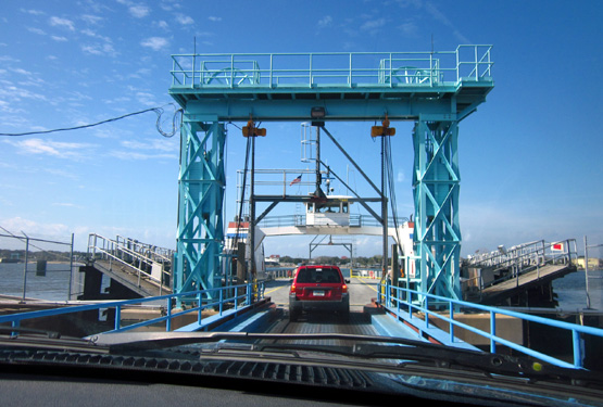
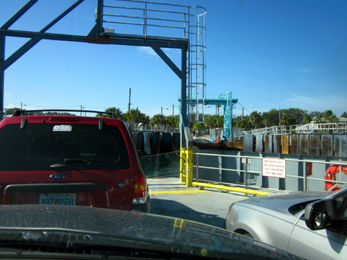
FERRY RIDE
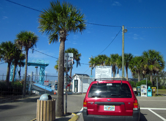
We drove off-base to US Hwy. AIA and went north a few miles to the little
riverfront town of Mayport. The ferry goes northbound across the river
on the hour and half hour and comes back at quarter after and quarter
till the hour from 6AM to 7PM.
We got there at 1:06 PM and had to wait 24 minutes to board the ferry.
We were second in line; only nine or ten vehicles got on going in
our direction:
The wait went pretty fast. We had one woman to talk with, signs to read,
birds and helicopters to watch, 14 vehicles to watch get off from the
other direction, and other distractions to pass the time.
We wondered if RVs can go on the ferry -- yes, but up to just
15,000 lb. That's about what our Cameo weighs when we're traveling
plus the weight of the truck. The one-way fee for vehicles over 20
feet long is $10.
We saw a good-sized travel trailer-pickup truck combo and a commercial
truck get off the ferry before we got on so I guess we could probably
take our camper across if we really wanted to.
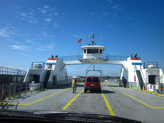
The ferry is run by the St. Johns River Ferry Commission and appeared to us to be an
efficient operation. The older fella who walked around to each vehicle collecting money was personable;
he joked around with us and gave the dogs a treat.
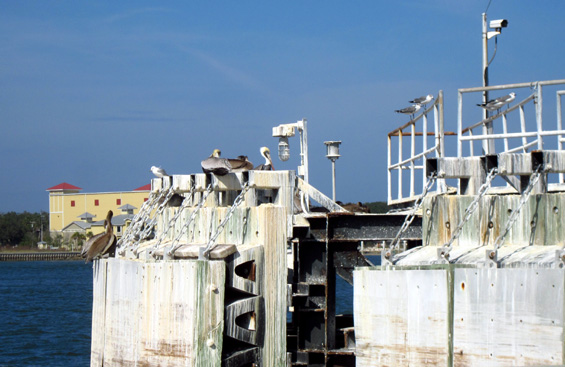
While we were waiting for the ferry to begin working its way across the
river I noticed all the pelicans and other shorebirds hanging out on the dock:
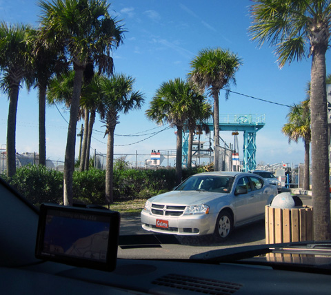
It took only five minutes to cross the river going northbound and secure
the ferry on the far side.
No one got out of their vehicles while we were crossing the river,
although passengers are allowed to do that. I got some pictures from inside the
truck as we went across the water and approached the other dock:
Vehicles were directed off the ferry in as organized a manner as they
got on. After exiting we continued north on AIA.
In about half a mile
we passed the entrance to Kingsley Plantation. We
didn't go in because it is open for tours only on
the weekends -- once in the morning and once in the afternoon. Since just
a dozen people can go on each tour we'll need to call ahead when we
return to Mayport in March if we want to tour the house and grounds.
We passed by and over a lot of water on our way to and from Fernandina Beach.
First was the wide
St. Johns River via the ferry. The remainder of the water crossings were on
bridges.
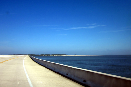
The next photo looks
east from FL 105 toward Huguenot Memorial Park. The long bridge
spans one of the
outlets of Deep Creek into the St. Johns River:
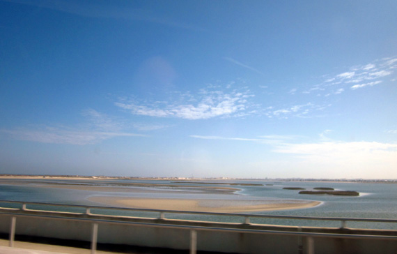
The tide is low in that photo. On the way back
we couldn't see those sand bars.
HUGUENOT MEMORIAL
PARK
About a mile after we
got off the ferry we came to the entrance
of Huguenot Memorial Park, named in honor of the French Huguenots who
settled Fort Caroline in 1564-5.
The park is shown on the map at the top of this entry but it isn't
marked there. It's the long green, hooked strip of land to the right of the
words "Fort George Island." We can see much of the shoreline
of the park from our campground across the river at Mayport Naval Station.
We turned in to see the price of entry
-- $1 per person for day use. There is also a campground in the park.
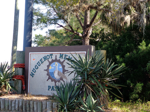
We didn't go in because dogs aren't allowed in the park with day visitors.
Pets are allowed in the park if you're a paid campground guest.
I'd like to go back to the park in March to hike and see the sand dunes
and crashing surf. They look inviting from our vantage point across the River.
THE TALBOT ISLANDS
We crossed the wide Fort George River and Inlet on a long bridge to
reach Little Talbot Island. Most of the island is a state park.
Ditto with North Talbot Island. We didn't go back into either park on this trip.
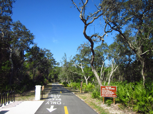
We noticed a paved bike path on the ocean side of the road in Big Talbot
State Park. I got out to read signs but there was no map or indication
of the length of the trail:
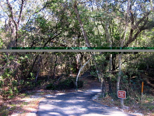
We could see the bike path from the road as far as the
long bridge over Nassau Sound. An older bridge to the west is used by
fishermen and possibly bikes.
The bike path continued through Amelia City but isn't done all the way
there. Crews are working on it now:
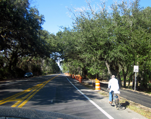
Jim measured 6+ miles that look
finished and another couple miles that are under construction --
probably not enough to make it worthwhile for him to ride there. He'd
have to ride on the shoulder where the path isn't finished.
AMELIA
ISLAND & FERNANDINA BEACH
After crossing Nassau Sound we were on Amelia Island:
Blue on blue
We soon entered the pretty little town of Amelia City. Route AIA passes
by a scenic golf course and through several attractive little
roundabouts to keep traffic flowing smoothly and slowly.
The residential and
commercial area of Amelia City
morphs into Fernandina Beach, which has a population of about 11,000
people.
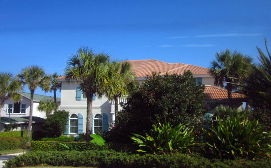
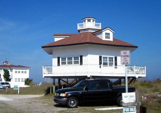
We stayed on the roads that are closest to the ocean in Fernandina Beach,
passing by about 20 access points to the ocean between the waterfront
houses. Residences ranged from attractive, expensive-looking two-story
houses to very basic boxes on stilts. Here are two examples:
It seemed to me that there were a lot of houses for sale. Florida's
housing market is still relatively depressed but improving. Winter is
probably a good time to sell in Florida because of all the snowbirds who
are down here now.
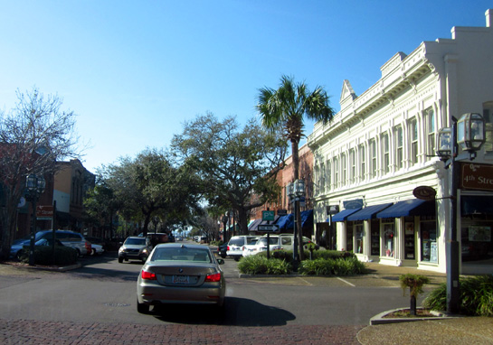
We went as far north in town as possible, then turned west toward
downtown on Centre Street, an eight-block pedestrian-friendly avenue
that is the heart of the historic downtown area:
The only place I entered along this street was the old Palace Saloon built in 1878; it is
reportedly the oldest bar in the state:
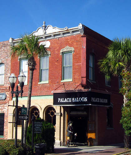
I went inside to see the 40-foot
carved mahogany bar and murals that I had read about in the AAA tour
guide but quickly left because of all the smoke.
My interior pictures didn't come out well enough to show them here.
We didn't see very many of the numerous old Victorian houses that are
reported to be in the Historic District. I wanted to get a driving tour
brochure at the visitor center but didn't see it either. We just weren't
real motivated that day.
A CLOSE CALL ON THE RETURN FERRY
We returned to the ferry the same route -- Route A1A. We could have
gone farther west from Fernandina to I-95 but preferred staying near the coast.
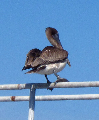
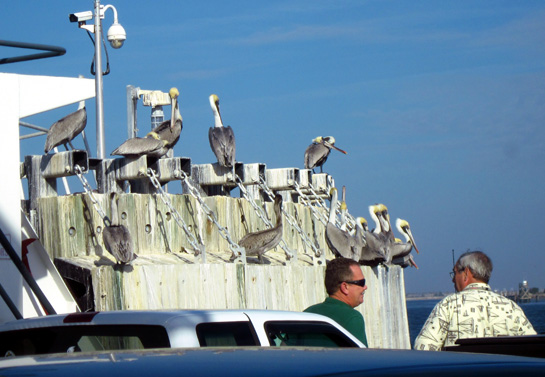
We just made the 3:15 PM ferry going southbound, next to last of about 20 vehicles.
I was able to get closer to the pelicans on the dock this time. About a dozen people were out of their
vehicles on that short ride so I got out to look, too:
I got back inside the truck before the ferry began to move. Good thing.
Just after we got started the ferry had to back up rather suddenly
because a large Navy ship was coming at us!
I assume it was the ferry operator's fault because passing ships would
have the right of way:
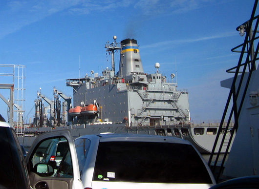
Too close for comfort
There was no collision and we got a very up-close view of the frigate. It must
have been going to the U.S. Navy Fuel Depot a little farther
west on the river. (I don't now if ships can go upstream as far as the
Naval Air Station.)
It was the USNS Kanawha T-AO-196, a fleet oiler, one of several
ships that have had the name Kanawha. I got back out of the truck to take
some pictures of it:
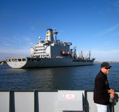
After the
Kanawha passed our ferry was able to proceed across the river. Since we
were going partly downstream it was a quick trip.
While I was
walking around I saw these two cyclists on the ferry:
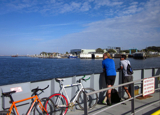
If Jim decides to ride his bike along north AIA he could take the ferry
and get an even longer ride from the campground.
Since we haven't ridden a ferry for a while this day trip was fun for
us. We plan to go back on the ferry again in March to see Kingsley
Plantation and Huguenot Park.
Next entry: lakeside camping at Kings Bay Submarine
Base near St. Marys, Georgia for the month of February
Happy trails,
Sue
"Runtrails & Company" - Sue Norwood, Jim O'Neil,
Cody the ultra Lab, and Casey-pup
Previous
Next
© 2013 Sue Norwood and Jim O'Neil