Continued from the previous page.
RAIN, RAIN, GO AWAY
It rained quite a bit on Wednesday, too, as we drove from
Dawson Creek to Fort Nelson, BC.
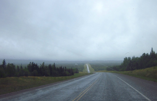
The Alaska Hwy., also known as BC 97 in this province, was mostly good through rolling
terrain although it is looking increasingly primitive. I commented
several times to Jim that "they need more paint," meaning there weren't
any lines on the road:
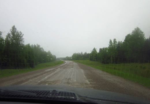
One of the gravel breaks
Long and lonely road from Dawson Creek to Fort
Nelson
We've morphed from all the agribusiness in Alberta to oil and gas
production and lumbering as the major industries in NE British Columbia.
Many little side roads lead to pipelines in this area but most aren't
visible from the highway because of all the trees. We've seen lots of
tanker trucks and logging trucks through this province.
We've been seeing standing water along the roadway and crossing a lot
of high streams in BC:
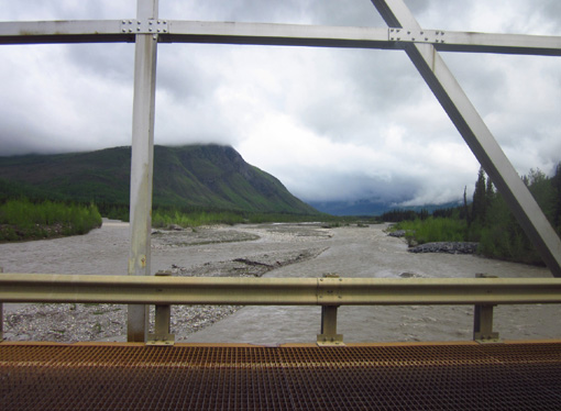
Metal grating bridge over the
muddy Lower Liard River
Yesterday we began to hear about flooding problems downstream from
all the rain this week, exacerbated by snow melting in the high country.
Although the Rockies in most of the U.S. had normal or below-normal
amounts of snow this year, farther north in Alaska and the Yukon the
levels were much higher. It's also been a cooler spring, so the snow is
melting later than usual.
The road came quite close to sections of the wide Tetsa, Trout, and Liard
Rivers today, with the fast-moving water just a couple feet below the
pavement:
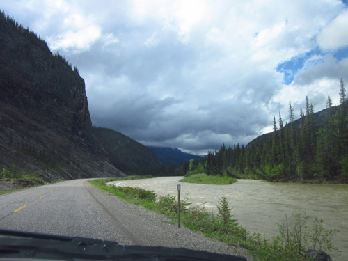
It wouldn't take much more rain
or snowmelt for this section of the highway to be flooded.
Some of the
rocky Liard riverbed is so wide it looks like the river would never go out
of its bed but it has before.
The color of the
water in all the high, fast-moving streams we could see is interesting.
I call it "cement" because it's a light tan color
unlike I've ever seen in a muddy creek or river. The color comes from
the alluvium (rocks, dirt, debris) that is washed down from the
mountains.
Just outside of Fort Nelson yesterday we crossed the Muskwa River, the
lowest point on the Alaska Hwy. at 1,000 feet elevation. Today we
crossed the highest point at Summit Lake, elev. 4,232 feet.
We spent last night at the Triple G Hideaway campground in Fort
Nelson:
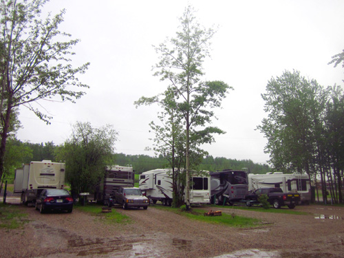
Packed in at Triple G campground;
we're sandwiched in the middle of four Class A motorhomes above.
For the first time on this trip through Canada we called ahead from
Dawson Creek to see if we'd need reservations at Triple G. The person I
talked with said no, but it's a good thing we got there early in the
afternoon because the place was almost completely full by suppertime
-- and it's a pretty big campground.
We were able to get a full hook-up pull-through site with cable for
$33 Canadian plus tax but the sites were very narrow -- wide
enough for slides to go out but with all the standing water and mud it
was a challenge to walk on either side of our camper to the back when I
took Cody for walks.
MAKING IT UP AS WE GO
That evening we had a lively discussion about how long to stay in
Fort Nelson. Another day or two of rain was predicted and I had concerns
about driving the challenging route through the Rockies to Watson Lake
in the rain.
My main concern was safety.
A secondary, much less important, concern was missing out on what's
considered to be the most scenic section along the entire Alaska Hwy. We
may not be coming back this way. I didn't want to wonder if the
mountains really existed, the same phenomenon folks experience who go to
Denali for one or two days and never get to see the peak because of all
the clouds.
This morning the clouds were breaking up in Fort Nelson. That seemed
to be a good omen.
After seeing our neighbors pull out we had more incentive to proceed
north and west. If they could drive that heavy Mobile Suites 5th-wheel
or those big motorhomes towing pickups and sedans behind them, well
surely we could get the Cameo up and over the mountains, too!
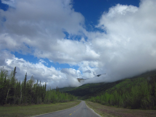
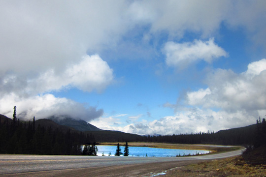
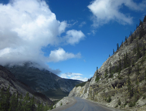
Naturally, it began raining soon after we left the campground. We drove in part rain, part sun today through the northern
Rockies to Watson Lake, YT.
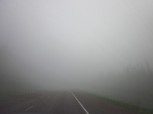
Dense fog for several miles this
morning as we ascended into the Rockies
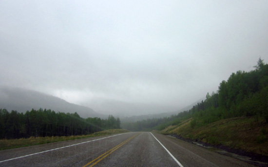
A little better visibility after a few miles
Now we're in the Pacific Time Zone, three hours behind Eastern DST.
Although we missed a few miles of scenery in the fog it was still a spectacular drive with
of snow-covered peaks, beautiful lakes, dramatic clouds, flooding
streams, dense forests, and wildlife we could see.
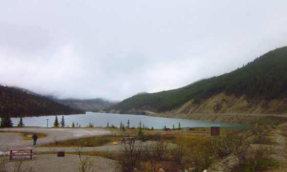
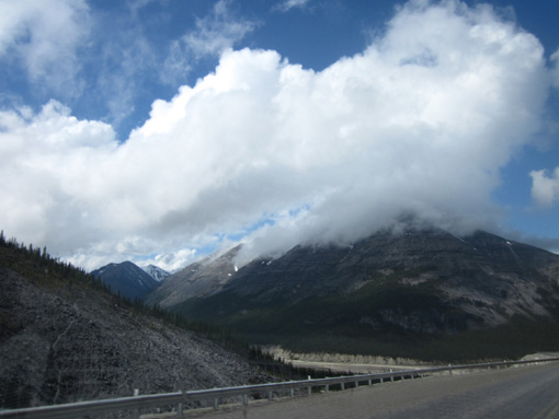
Above and below: Summit Lake is a nice place
to camp, fish, or take a break.
If it had been warmer and sunnier this afternoon we might have stayed
overnight at Muncho Lake or Liard River Hot Springs, both very popular
areas with residents and tourists. Soaking in the hot springs is
considered a "must do" experience when traveling the Alaska Hwy.
It was raining so much when we passed the springs that we didn't even
go in for day use or to take pictures.
Maybe we can do that on the way
back in the fall. It's often mentioned in travel blogs as one of their
more memorable experiences by folks who've been there.
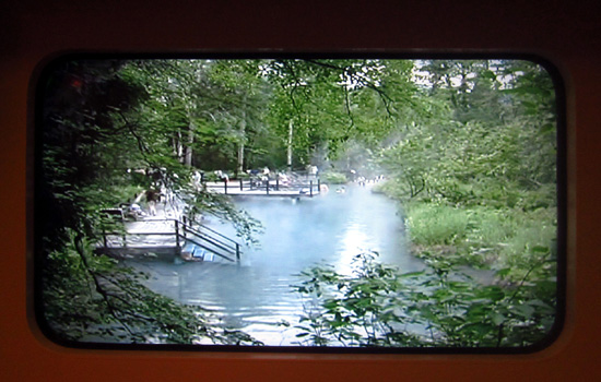
Picture of the Liard River Hot
Springs from a screen at the Alaska Hwy. House in Dawson Creek
In some ways this trip reminds me of our MO for the Appalachian Trail
Adventure Run in 2005.
For both trips we did extensive online research and
read hiking (travel) blogs and other materials but we weren't sure how
long I'd hike (or we'll drive) each day or where we’d stay. The whole
trail (Alaska trip) is too big to
grasp so we often plan the day or night before for the next day.
WATSON LAKE, YT
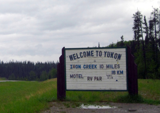
Between Contact Creek, BC and Teslin, YT the Alaska Hwy. crosses the
border of the two provinces six or seven times. On our way to
Whitehorse, YT we'll be back in BC one or more times.
There are "Welcome to the Yukon" signs at the crossings we did today.
Here is the first, rather primitive, one:
An RV was parked in front of a much nicer welcome sign before Watson Lake and I
couldn't get a picture of it from the road.
That reminds me -- we're already beginning to see some of the
same RVs from place to place as we travel about the same number of miles
each day. Three of our neighbors from Triple G are in the other
campground here in Watson Lake. One of them left a water connector at
Triple G and Jim returned it to him this afternoon. The man joked that
he's left those all over the U.S. and Canada and this was the first time
someone returned one to him!
Another observation about RVs in Canada -- it seems like more
Canadians than U.S. residents have campers. So many of the homes and
businesses we've passed in Alberta and BC have a motorhome or trailer in
the yard. That's cool. There are so many beautiful lakes and parks up
here; it's good to see the residents like to get out to camp.
Or maybe they all head south in the winter!
I'd guess that many of them fish, too. We've been warned that the
provincial parks with lakes (like Muncho) fill up fast on Friday with
locals who fish on the weekends. Canadians tend to do more subsistence
fishing and hunting than U.S. citizens do. It's no wonder, considering
the cost of meat, fish, and poultry up here.
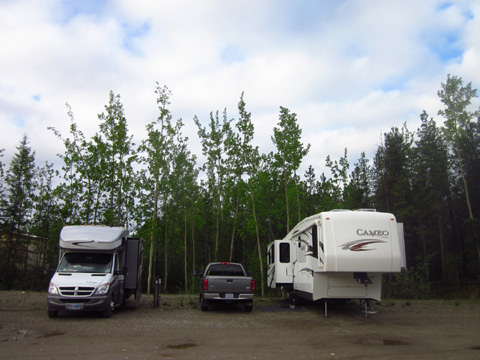
Our home for the night in the Tags RV Park at Watson Lake
When we reached Watson Lake this afternoon we had two public
campground choices in town -- the 140-site Downtown RV Park across
from Wye Lake or the 40-site Tags RV Park behind the Tempo gas station and
convenience store. Both are basically gravel lots with hook-ups.
Based on information in the Churchs' Alaska Campgrounds book we chose
the Tags campground. It's less expensive and the sites are a little
larger. Half are full-hookup, pull-through sites in the middle of the
parking lot. The other half are back-ins with just water and electricity
next to spruce and aspen trees. The sites cost $26 and $23/day
plus tax, respectively.
When we came in only a dozen RVs were already parked so we had several
good choices. Since we plan to spend only one night here, Jim chose a
back-in site where there is no standing water from all the rain.
If this CG was full we'd have neighbors within just a few feet of us.
Fortunately, no one is on either side of us within 15 feet.
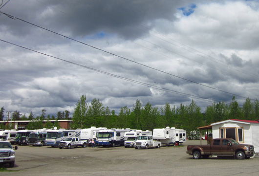
Packed in at the Downtown RV Park
The Tags campground is new
enough that it isn't listed in our 2011 Mileposts book. The other
CG, shown above, is pretty full, especially with large motorhomes. The spaces over
there are very tight with barely enough room to put out slides, let alone awnings.
I'm glad we chose Tags.
We have about 11 cable TV stations and so-so WiFi. We need
those diversions when it's raining! The clouds are finally breaking up,
however, and the rain has
ended for a few days, making it more fun to check out the visitor center
across the street and walk through the adjacent Signpost Forest.
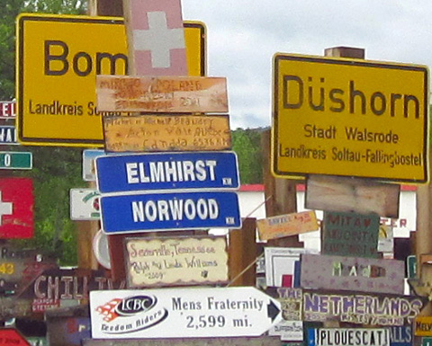
WE WERE HERE
What is it about humans that they feel compelled to leave their mark
while traveling? One example is the graffiti you sometimes see on rocks,
bridges, and other places. Heck, even Lewis & Clark left their names
here and there during their famous expedition to Oregon!
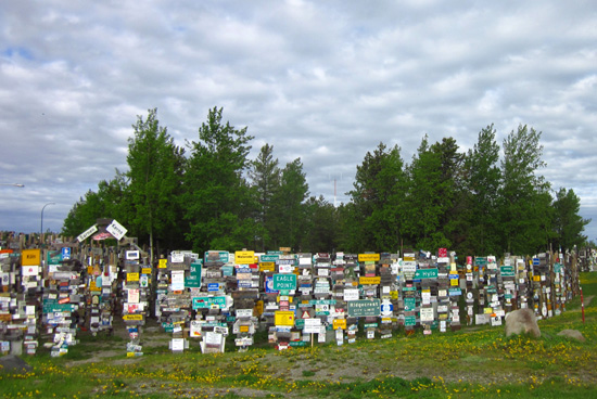
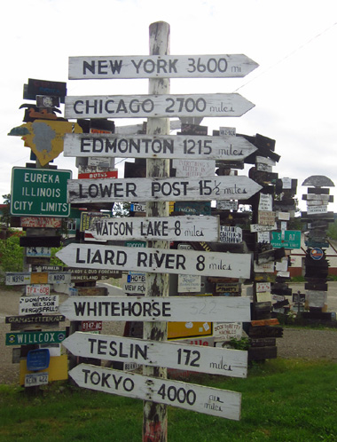
Watson Lake, YT has one-upped this concept. It's got the Signpost
Forest, where tourists from all over the world have left their marks
announcing they were here.
The Signpost Forest is one of those touristy "must do" things the
first time you come this way. It's a work in progress as more and more
signs are added each year, so repeat visitors often stop each time they
come through just to see what's new.
It's free and probably as much fun for kids as for curious adults.
There is plenty of RV parking along the highway or by the visitor center
if you're just passing through and not staying overnight.
I encourage you to spend at least a few minutes wandering through the
"forest" and even leave a sign to be added to the burgeoning collection.
If you don't have one you can buy a blank sign locally and add your name
and hometown. We knew all about the Signpost Forest before we left
Virginia. We considered bringing an old license plate or making a sign
but decided against it. We like the place but we just don't feel
compelled to leave our mark here.
Cody-pup did, though. He marks his territory everywhere he goes!
The first signs from 1942
Begun in 1942 by a homesick soldier working on the Alaska Hwy., the
Signpost Forest now includes over 71,000 signs and license plates left
by visitors from all over the world. I saw several from as far away as
Singapore and Australia.
It's fascinating to walk through the "forest" of tall posts and look
at the memorabilia . There's everything from metal town limit signs to
hastily-written plastic plates to elaborately routed wooden signs with
people's names and home towns on them. Many signs are from Europe,
particularly Germany and Scandinavia.
We were very happy when the sun came out this evening. Jim rode
his bike around town and I took Cody on a 3-mile walk to and around
scenic Wye Lake, passing through the Signpost Forest on our way out and
back.
We didn't take time to visit the Northern Lights Centre to watch
their films about the aurora borealis. I'd like to do that if we
come hack this way in the fall.
We were in bed tonight before sunset again.
WHAT'S NEXT?
We hope for a few days of sunshine as we head to Whitehorse, the
beautiful Kluane Lake and National Park, and the Alaskan border. We're
up to here with rain. <frown>
Some of our impressions of the places we're passing through in Canada
are colored by the weather. It's only natural to enjoy an area more if
it's sunny. An example is Grande Prairie, where we got out on the
greenway on a sunny afternoon and had a great time. That makes us more
likely to want to go back there sometime.
Our moods are greatly affected by the weather, too. Jim and I are
outdoors people. When the weather's bad we don't hike as much or ride
our bikes at all -- and we get cranky.
It's not fun to drive in the rain either. It's more intense and we
miss interesting scenery we may never see again. We hope it's not a
particularly wet summer in Alaska. I remember reading trip journals from
the summer of 2008, e.g., when RVers had rain most of the time they were
there.
I'll do my best in this journal to temper my descriptions of places
we visit when it's raining. I don't want to do a disservice to any
campground, town, or area just because we hit lousy weather when
traveling there. I'm an optimist who tries to find the best in
everything (making lemonade out of lemons). I hope I can do that on this
trip.
Stay tuned for another update when we reach the Alaska border. We plan to spend at least two nights in Whitehorse so we can do
some interesting things there and maybe visit with friends who live
there. We should be in Alaska by Tuesday.
I'll have more details eventually about our trip through British
Columbia. I've got a lot more photos to show you.
Next entry: our summary through the southwestern corner of the
Yukon to Alaska.
"The Yukon." Doesn't that sound exotic?!
Happy trails,
Sue
"Runtrails & Company" - Sue Norwood, Jim O'Neil,
and Cody the ultra Lab
Previous
Next
© 2012 Sue Norwood and Jim O'Neil
