Now we really feel like we're on our way to Alaska!
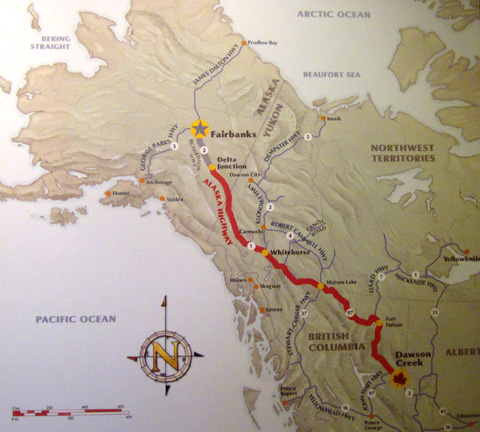
We've been driving on the famed Alaska AKA Alcan Highway for the last
three days and have made our way through the far NE corner of British
Columbia to the SW corner of the Yukon Territory. This two-page entry is a summary of that
journey.
CAPTURING THE IMAGINATION
If you're approaching the 49th state from the east I highly recommend
staying long enough in Dawson Creek, BC, the southern terminus of this road,
to visit the Alaska Highway House and watch the excellent 50-minute PBS
film documenting the construction of the highway:
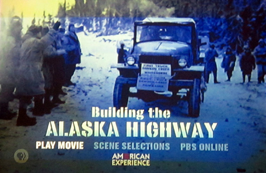
Entrance to this museum is by donation and the movie is shown at the
top of each hour.
This is the fascinating story about U.S. and Canadian efforts to
protect North America after the Japanese bombed Pearl Harbor in WWII. In
about eight months 30,000 American and Canadian troops and civilians
punched a primitive 1,500-mile road through the wilderness from Dawson
Creek, BC to Delta Junction, AK in one of the most ambitious government
projects of all time.
It’s incredible they were able to accomplish what they did through such
remote, rough terrain and under such extreme weather conditions:
- temperatures ranging from minus 40 F. to plus 90 F.,
- torrential rain and hail,
- snow, mud and muskeg (similar to alpine bogs in Maine) so deep the
men and machines got mired down repeatedly,
- huge, annoying mosquitoes and flies,
- pesky bears,
- primitive living conditions,
- etc.
In addition to all those challenges, the Black engineers and troops
had to deal with incredible prejudice. The film underscores the
fantastic job they did, too.
There are numerous original still and moving pictures of the men, the
machinery, the conditions, and the terrain in the film and in museum
displays at the Alaska House and the renovated grain elevator housing
the Dawson Creek Art Gallery. They are very interesting to see.
The Alaska Highway has been a work in progress ever since. Some folks
consider it to still be rather primitive. I had to
laugh when I saw this more modern (note the word "dude?") wooden plaque displayed in the museum at the
visitor center in Dawson Creek:
Alaska Highway:
Winding in and winding out
Fills my mind with serious doubt
As to whether the dude who built this route
Was going to hell or coming out!
This year marks the 70th anniversary of the road's completion. All of
it is paved now (except through "gravel breaks," portions that are under construction every
summer from frost heaves and wear and tear) and it is several miles shorter due to periodic re-routes to
make it easier to drive.
The highway serves both as a critical lifeline for many communities
along the way and is the major eastern route for goods and tourists to get to
and from Alaska.
After watching this film you'll not only have a deep appreciation for
the amazing feat the U.S. and Canada accomplished 70 years ago, you'll
also have a deeper appreciation of the current paved road you'll travel
on to reach Fairbanks or Anchorage.
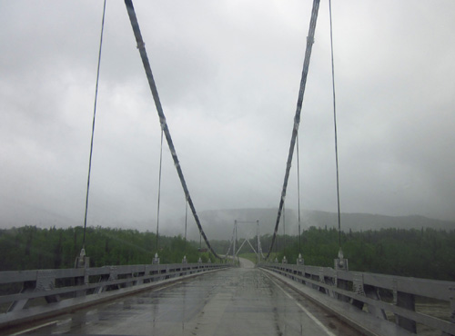
Today we drove over the only remaining suspension
bridge on the Alaska Hwy.
At 1,400 feet long, it spans the mighty Lower Liard
River, as big as the Mississippi.
The Lower Liard River looks like a lake at this
spot a few miles downstream from Watson Lake, YT.
Every time you cross a long bridge over a deep
canyon with one of many rivers rushing below you, pass within several
feet of gorgeous glacier-fed Muncho Lake with a rock wall on the other
side, or hit yet another pothole or gravel break or frost heave . . . you can
recall scenes from the documentary that will make you glad you don't have to
travel this major artery to Alaska on a primitive dirt road any more!
It's still primitive in some ways, but it's much better than it was
originally.
THE ADVENTURE BEGINS
We've heard plenty of stories about how adventurous travel on the
Alaska Highway can still be:
- long, steep grades down into numerous
river canyons and back up the other side,
- waiting for one-lane traffic
through construction zones,
- having windshields chipped or broken from
flying gravel when big trucks go whizzing by too fast,
- slowing down repeatedly for bumpy sections of the road
- dodging rock slides and wildlife on the road,
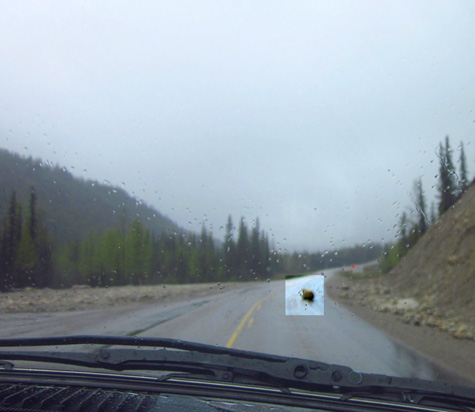
One of the rocks we had to dodge
is highlighted in the photo above.
Good thing no one was coming the
other way!
- possibly
encountering snow through the northern Rockies or Cassiar Mountains even
in the middle of summer,
- losing phone signals in remote areas for days at a time,
- having difficulty finding internet connections,
- having
difficulty finding a campsite in some areas if you're traveling at the
same pace as a lot of other RVers . . .
That's just a start of what we've heard and read. It wasn't enough to
discourage us from taking this historic route, however. The few other
routes, including ferrying up the coast, have their own challenges.
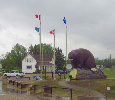
Large beaver statue at the
visitor center in Beaver Lodge, AB, near the BC border;
there are beaver dams in the
numerous ponds and wetlands we've passed.
The good news is that after traveling the first section of the Alaska
Highway this week from Mile 0 in Dawson Creek, BC to a few miles over the Yukon
Territory line at Mile 612 in Watson Lake we haven't run into any
major problems yet, and very little roadwork or traffic.
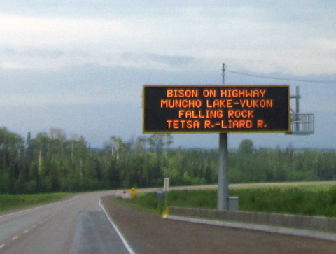
It's imperative to remain alert at all times on the Alaska Highway,
however. The signs warning about rock slides, road work, and large game
on the road are for real:
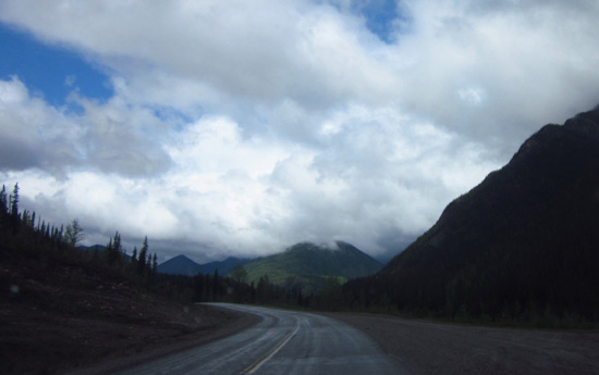
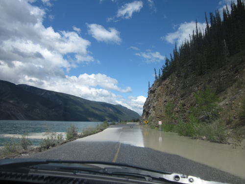
Today was our most "adventuresome" day on road so far, with some rain
through the northern Rockies where you have to drive more slowly even on
a dry, sunny day, thick fog in that area for several miles that reduced
our visibility to about 150 feet, several inches of water on the road near Muncho
Lake where a creek was over its banks (a road crew working to
un-clog a culvert waved us through that), rocks in the road in several
places that we had to go around, and a wood bison sauntering across the
highway right in front of us:
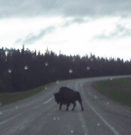
We had to stop to let this big
wood bison cross the road.
We read that they sometimes sleep
on the warm pavement at night!
Fortunately, traffic was so light we could safely make these stops
and maneuvers. We kept wondering where everybody was.
The amazing mountain scenery and spotting lots of wildlife along the
road made it all worthwhile. We saw about five stone sheep on a rocky
slope, half a dozen black and grizzly bears between the road and the
tree line, and even more wood bison than that.
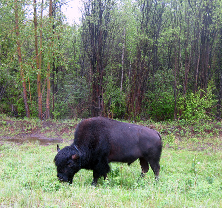
Wood bison grazing
along the highway
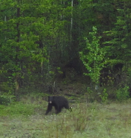
This is the only bear I could "catch" with my
camera today.
Our critter count was good today!
We still haven't seen any elk,
caribou, or moose, although the habitat is perfect for those species
-- lush green grass and new leaves on trees and shrubs, plenty of
water, and millions of acres to roam free.
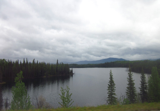
This is gorgeous wilderness territory and we're excited to be here.
The only disappointment is all the rain we've had the last three
days. That's why it's so green up here.
DAWSON CREEK: IT'S ALL ABOUT MILE 0
It began raining before we left Grande Prairie on Tuesday morning. We
drove only a little more than an hour that day to reach Dawson Creek because we wanted to spend
the afternoon visiting several landmarks in town.
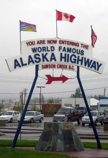
The historical Mile 0 post
(above) and a newer one nearby (below)
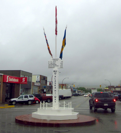
In addition to the Alaska Highway House we saw both the historic and
newer Mile 0 posts and the visitor center, railway station museum, and
art gallery at the Northern Alberta Railways Park.
All are within
two blocks of the roundabout halfway through town. (So far most of the
small towns on the Alaska Hwy. have been linear -- only a block
or two wide but very long.)
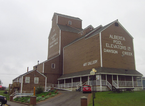
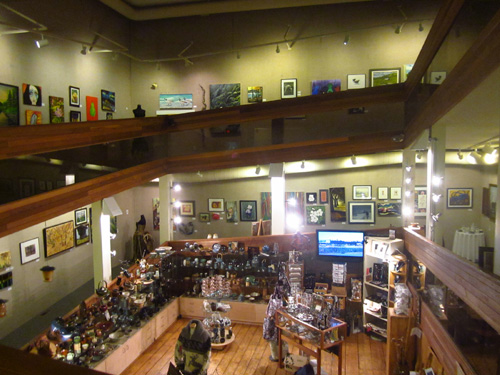
Exterior and interior views of
the renovated grain elevator housing an interesting art gallery

The visitor center and a railway museum are in the
old train depot.
We passed the WalMart store on the way into Dawson Creek and decided
it was too small to park overnight there.
We spent that night at the Mile 0 RV Park at the other end of town.
It's a nice campground with pull-through water and electric sites for
$32 Canadian plus tax. We got there early enough to get a spacious site
at the end of a row. We parked on gravel with grass (and mud and
puddles) on either side. The place was mostly full by late afternoon.
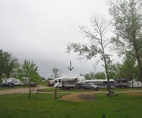
Mile 0 Campground:
our rig is under the arrow
One bit of advice we've heard repeatedly about traveling the Alaska
Hwy. in an RV is to start early every morning and stop early every
afternoon in order to 1) get a decent campsite and/or 2) be able to explore the
area a little bit before moving on.
It's true. At this time of year these campgrounds fill up quickly each day and if you
don't have reservations, which is our MO most of the time, you could end
up having to dry camp overnight at one of the many parking areas along
the highway instead of having water, electricity, maybe a sewer and
cable TV, and a WiFi signal at a campground.
We had planned to boon-dock more than we're doing on our way through Canada.
So
far we're spending more time at campgrounds so we can get WiFi. It's
critical that we keep tabs on the weather and road conditions as we
proceed up this highway. It's also important to us to know what charges
are being made on our credit cards, to read our e-mail and news reports,
etc.
We aren't using our personal Verizon MiFi through Canada because
it's outrageously expensive. It's also useless through much of British
Columbia and Yukon where there is no Verizon cell service.
COMFORT VERSUS THRIFT
Another reason we chose to stay in campgrounds the last four nights
is the rain.
We're simply more comfortable in an RV during rainy weather when we
have water and electrical
hook-ups. We spend more time inside the camper and like having TV and
internet diversions. We can use our electric space heater and not mess
with the generator. We can't rely on all those solar panels for power in
the rain and having hook-ups saves time and hassles; we
don't have to hunt for water and dump stations.
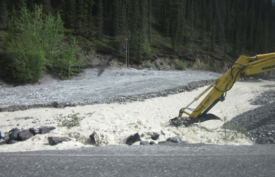
Highway crew busy scooping rocks,
mud, and debris from a culvert
in a creek as we approached Muncho Lake.
Instead of flowing under the
road, the water was covering the highway at a low point.
This is how washouts of the Alaska Highway begin.
Fortunately, this one was averted.
There are very nice, less expensive alternatives to private
campgrounds such as Mile 0, of course.
We've seen more municipal (public/city) campgrounds in Alberta and British Columbia than in the States.
We really liked the Rotary Club campground in Grande Prairie and we've
seen others like it along the highway in other towns. They are a little less expensive than
private campgrounds with comparable services but not as cheap as most of
the provincial parks. Both city and provincial parks tend to have more
spacious sites than private campgrounds (ditto in the U.S.).
So far most of the provincial parks in Canada have been farther off
our route so we haven’t used any of those yet. We would if we were
spending more time at a particular location. The provincial parks are
often in more remote locations that are less likely to have WiFi at the
campsites. That's a limiting factor for us while we can't use our
personal MiFi card to get online.
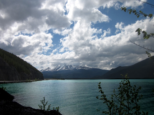
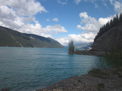
Above and below: we enjoyed
lunch along beautiful glacier-fed Muncho Lake.
Speaking of expenses, diesel fuel definitely costs more and more as
we go farther north.
We paid $1.519/liter for diesel in Fort Nelson, the highest so far. That
translates to ~ $5.75/gallon Canadian and only a little less American.
Diesel is less expensive in Watson Lake, YT at the Tempo
station next door to our current campground ($1.409/liter Canadian).
We're hoping the next fill-up in Whitehorse costs less since it's a
larger town.
And groceries? We paid a whopping $6.13 Canadian for a gallon of milk
at the IGA in Fort Nelson. Yikes! It's not that much less when converted
to U.S. $$. Compare that to $1.62/gallon in Colorado Springs a couple
weeks ago. (Granted, that's cheaper than anywhere else we got it in the
U.S., but still . . .)
Everything else -- produce, dairy, poultry, canned goods,
snacks, etc. -- was two to four times what we're used to paying
at WalMart in the States.
Continued on next page so it's easier to load the photos . . .
Happy trails,
Sue
"Runtrails & Company" - Sue Norwood, Jim O'Neil,
and Cody the ultra Lab
Previous
Next
© 2012 Sue Norwood and Jim O'Neil
