We haven't driven those scenic roads in Italy or
Germany but we can vouch for the stunning scenery along Turnagain Arm.
If you visit Alaska a drive, a train ride, or a
bike ride along this stretch of highway should be on your Top Ten List
of Things to Do.
Today’s weather turned out better than we expected so we decided to take
a drive. We went farther than Girdwood to the eastern
end of the arm at Portage, about 65 miles outbound from Anchorage, then turned around.
This trip just made us hungry to see more things the next time we're
there.
In this series of
entries I'll describe what we saw and did along the way.
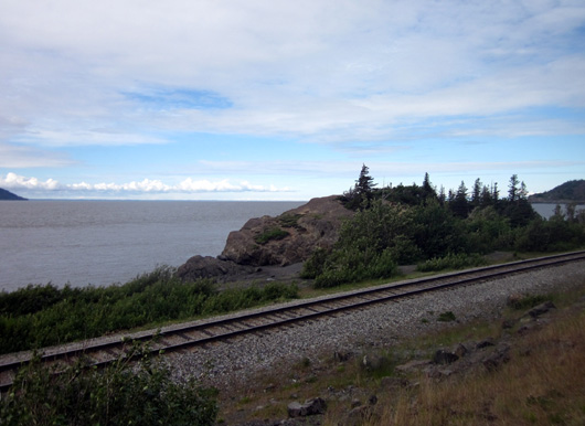
The
Alaska Railroad tracks run right next to the water between Anchorage and
Girdwood.
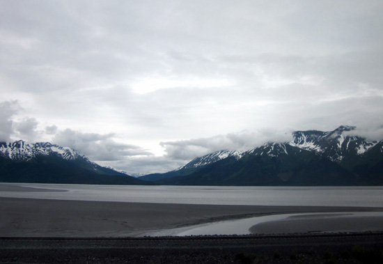
Cook
Inlet is in the distance in this photo, which I took a few miles south
of Anchorage.
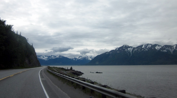
Although
there were a lot of clouds in the morning we didn’t get into any rain and we could see
most of the peaks in the Chugach and Kenai Ranges. Snow was down to the road level in some
places.
It was sunnier
in the Portage Valley and on the ride back to Anchorage.
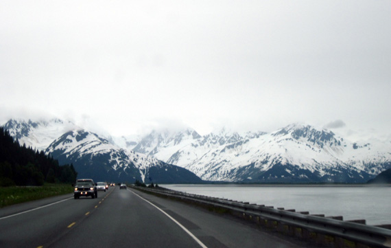
I'm not real pleased
with the photos on this page that I took this morning along the Arm. I
think the problem was using the wrong settings while facing southeast
into the sun, which was hidden behind clouds as we drove toward Portage.
I also took many of the pictures while the truck was moving, like the
one below:
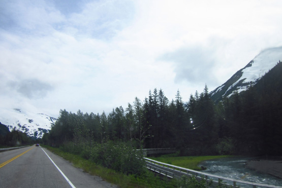
My east-facing morning photos came out blue, gray, and
black. <frown> This is a really
narrow land corridor right here for the
highway and railroad tracks, which are on the right.
Our Canon camera is
also about to self-destruct. We picked up a new, more powerful Sony
digital compact camera
after getting back to Anchorage this afternoon. Maybe tomorrow's
pictures will be better.
Just trust
me when I say the views along Turnagain Arm are spectacular.
The photos I took at
Potter Marsh, Portage Lake, and Byron Glacier came out better when it
was sunnier and I faced different directions. I'll talk about those
areas on subsequent pages in this series.
A MUST-DO DRIVE
This map section from The Milepost (p. 543 of the 2011 edition of
the book) shows where we drove today:
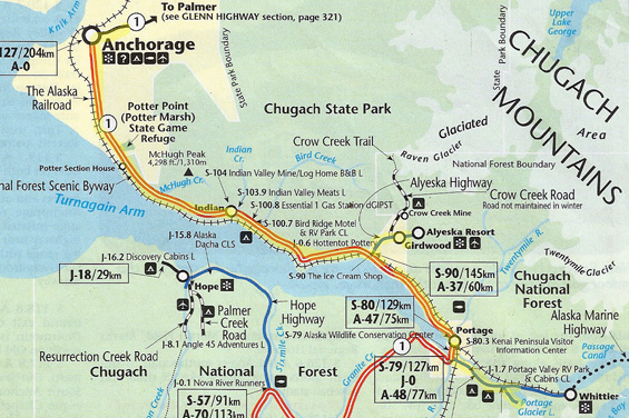
I highlighted our route in yellow.
Turnagain and Knik Arms are extensions of Cook Inlet, the larger body of
water to the left (part of the Pacific Ocean).
The Seward Highway connects Anchorage with the coastal
town of Seward on the southeastern side of the Kenai Peninsula. It
stretches a total of 127 miles. The mile markers begin at zero in
Seward. We thoroughly enjoyed the northern half
of the road today. We'll see the rest of it when we go down to Seward in
July.
The section of the highway we drove today between Anchorage and the
intersection with the road to Whittier, the Portage Valley Road, is very heavily traveled.
Why? It is the only road link from the mainland
to Girdwood, Whittier, and the Peninsula -- and it is
extraordinarily scenic. It draws both residents and tourists like a
magnet.
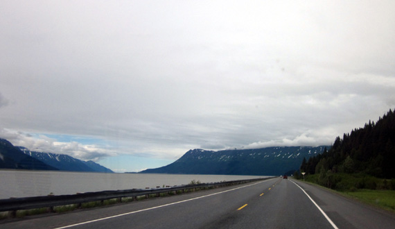
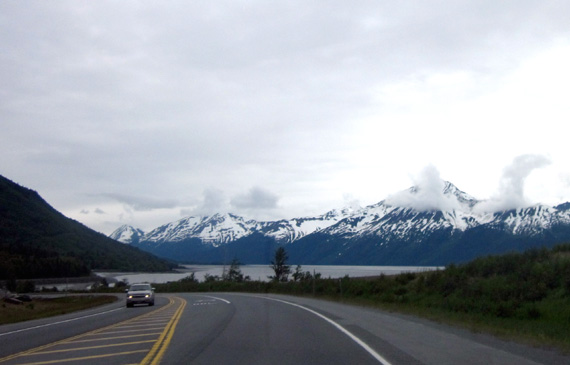
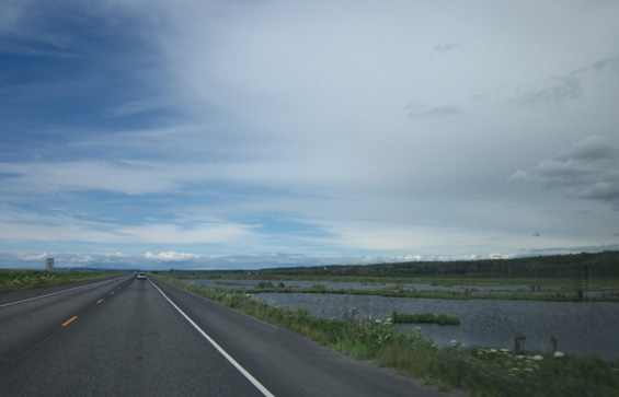
View heading
back to Anchorage this afternoon
Not only do you have the rather narrow body of
water extending east from Cook Inlet where you can watch the tides come
in and out and enjoy other water-related activities, there are also snow-capped mountains up to 4,000 feet high on either side of the
Arm -- the Chugach Range to the north and the Kenai (KEEN-eye) Mountains to
the south.
Both ranges are in the huge Chugach National Forest,
which covers almost 17˝
million acres on the mainland between Anchorage and the Copper
River Valley, as well as the Kenai Peninsula.
Glaciers abound in these mountains and feed
streams that flow into Turnagain Arm. Waterfalls that tumble down the
steep slopes in the summer become multi-tiered icefalls in the winter.
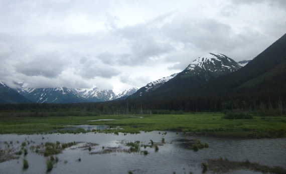
We could see
several glaciers in the Kenai Range at the far end of Turnagain Arm.
The terrain on either side of Turnagain Arm is
rugged and varies widely from high, rocky peaks to flat-bottomed
valleys. The diverse terrain supports many habitats, including streams,
wetlands, hillside boreal forests, and treeless alpine tundra.
Treeline
occurs at only 1,500 feet elevation here, much lower than in the Lower 48
states.
Both plants and wildlife are diverse as well.
White Dall sheep love the high rocky ledges above the highway and farther
inland. Several kinds of salmon return to the streams to spawn, attracting
eagles, bears, and whales. The wetlands provide food for moose, other
mammals, ducks, trumpeter swans, and numerous migrating birds.
The scenery is so outstanding that the Seward Highway
has been designated as a National Forest Scenic Byway and an Alaska
Scenic Byway. It is also one of only fifteen roads in the U.S. designated
as an All-American Road.
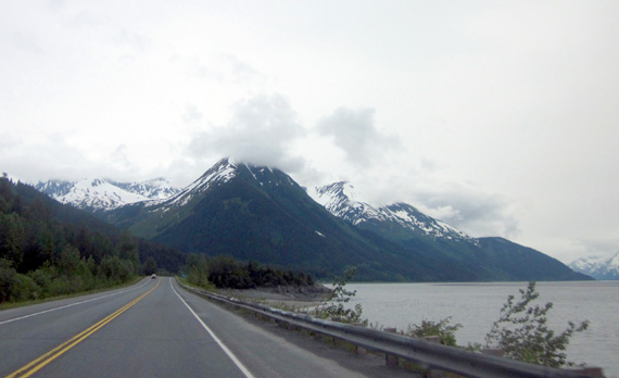
Clouds hung
over the Chugach Mountains most of the day but it was still a scenic
drive.
Most of the Seward Hwy. between Anchorage and
Portage is two lanes wide. One or two short sections have passing lanes.
The road curves around the bases of the mountains on the north side of
the Arm but none of the curves are tight.
The pavement is about the smoothest we've seen
anywhere in Alaska this summer, perfect for RVs.
And that often causes traffic problems in the
summer -- tourists, especially the ones in lumbering RVs, who are gawking at the scenery, slowing
down to look for Dall sheep or bald eagles on the cliffs near Beluga Point (or
whales in the water), scanning the water for unique bore tides, and
pulling into and out of the numerous overlooks along the roadway.
The sign at
this pull-off says no trespassing but the well-worn paths on the
other
side of the
railroad tracks show how many people have ignored the sign.
Folks hauling fishing and recreational boats
move more slowly than other traffic, too.
Local residents and commercial truckers tend to get annoyed with the
tourists and boaters.
Apparently they tend to follow too closely and/or take risks when
passing because there is a high rate of accidents on this stretch of road
in the summer.
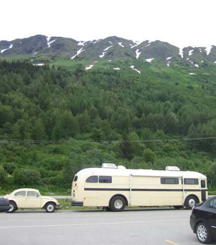
Cool
renovated hippie-mobile and
matching toad we spotted at one of the turn-outs
Today we were in just our truck and not towing
the Cameo. Jim mostly drove the speed limit or faster to keep up with
traffic. It's clear that when we take the camper to the Kenai
Peninsula in a few days we'll have to drive near the speed limit and
pull over when we want to take pictures or look for wildlife.
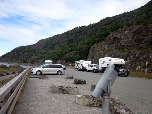
There are many places to pull off the road.
Consider that if you're sightseeing in an RV or
driving slowly in a passenger vehicle.
Also keep in mind that in
some places in Alaska it's mandatory to pull over when more than five
vehicles are behind you. In some places along the Arm today we were in
one long line of traffic. I imagine it's even worse on weekends when
Anchorage residents head to and from the Kenai Peninsula, which is a
favorite playground of theirs.
ARE BORE TIDES BORING?
Today we
pulled off onto several of the turnouts along the highway.
Many of them have interpretive
signs about the formation of Turnagain Arm, bore tides, marine life, Dall
sheep, nearby glaciers, and historic events like the gold rush and the
1964 earthquake.
We either read most of the signs this morning or took pictures of them
to read later. Some of the information in this entry came from those
panels:
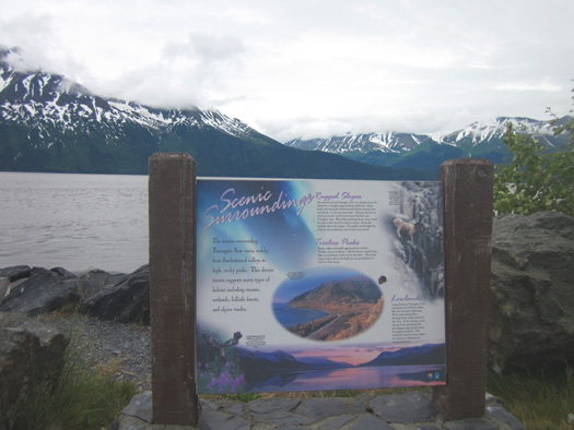
I encourage visitors to stop and read these
signs the first time through here. You can learn a lot about the geology, history,
and culture from them. They're all over Alaska.
I'll share a few facts that I found interesting.
Glaciers advanced and retreated through this
valley five times, beginning about one million years ago. Some of the
advancing ice was
thousands of feet thick The result was this narrow inlet with high,
steep walls on either side.
The walls of the U-shaped valley continue
beneath the water to an unknown depth. Over the eons tons of glacial
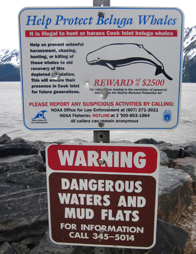
sediment have filled the valley bottom and created extensive mudflats
that are exposed when the tides are out. As on the Coastal Trail in
Anchorage, there are signs along the Seward Hwy. warning people to avoid
walking out in the mud.
It's as dangerous as quicksand. Some people have
drowned when they couldn't get out of the mud or been rescued by others
before the next tide came in.
Speaking of tides, bore tides are anything but boring. They are
rather unusual and occur in only about 60 places around the world. Turnagain Arm has the second-highest bore tides in North America, behind
the Bay of Fundy in Canada.
Quoting from another
website
about Turnagain Arm, "A bore tide is a rush of seawater that returns
to a shallow and narrowing inlet from a broad bay. Bore tides come in
after extreme minus low tides after a full or new moon . . .
Alaska's most famous bore tide occurs in
Turnagain Arm, just outside Anchorage. It climbs up to 6-10 feet tall
and can reach speeds of 10-15 miles per hour. It takes not just a low
tide but also about a 27-foot tidal differential (between high and low
tide) for a bore to form in Turnagain Arm."
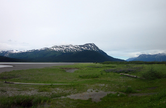
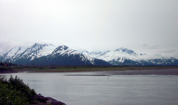
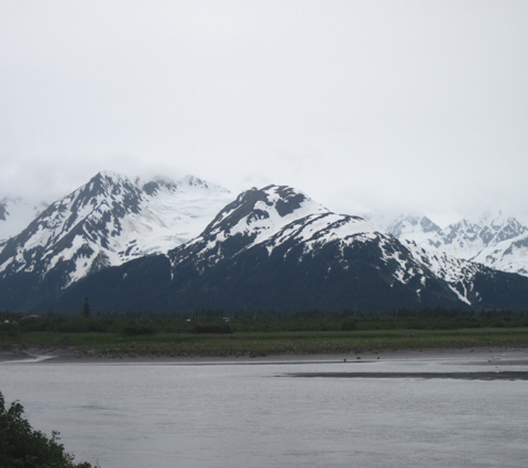
Low tide at
the far end of Turnagain Arm this morning; this is near the former town
of Portage.
The website explains that what makes Turnagain
Arms' bore tide so dramatic and unique are its size (one of the largest
in the world), it's the only one in the far north, and it's the only one
bordered by mountains.
It's also very accessible for 40-50 miles along
the Seward Hwy. It takes the bore five hours to travel from the mouth
near Anchorage to
the end of Turnagain Arm at Portage, giving plenty of opportunity along
the Seward Hwy. to see it when it occurs.
The website has suggestions for where and when
to view the bore tides. You need to know when the five-day "windows of
opportunity" exist around the full and new moons and must consult
detailed tide tables to time it right. You can get both from NOAA's
website. (NOAA also monitors oceans, not just weather.)
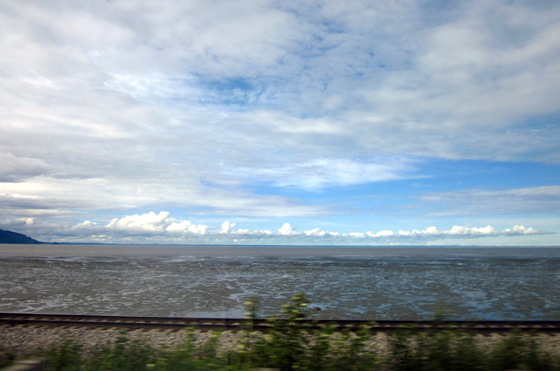
You can see
some of the mud flats at low tide near the mouth of Turnagain Arm in
this shot I took
a little south of Anchorage this morning. Cook Inlet is the large
body of water in the distance.
We spent about six hours along the Arm today.
Low tide in Anchorage was about 8:10 AM, high tide about 1:50 PM.
That
means the tide was still going out as we proceeded east toward Portage
this morning. (I'm not sure if it takes five hours to go out as
well as come in, but I'm assuming it does.)
We could still see a lot of mud in the last few
miles near the far end of the arm around noon:
A creek
empties into Turnagain Arm at low tide. The Kenai Mountains are in
the background.
By the time we got back to Anchorage in the
afternoon the
tide had already come back in there.
We didn't see any waves rolling in on the way
back,
probably because we're about halfway between a new and full moon. Maybe
we'll get lucky and see a bore tide when we travel down to or back from
the Kenai Peninsula in July.
BELUGA POINT TO GIRDWOOD
Reportedly one of the best places to see Dall sheep is on the hillsides
above Beluga Point at MM 110.
When we pulled off at the overlook Jim got out the binoculars, pointed
them where other people were looking, and found a herd of
seven sheep in a high meadow:
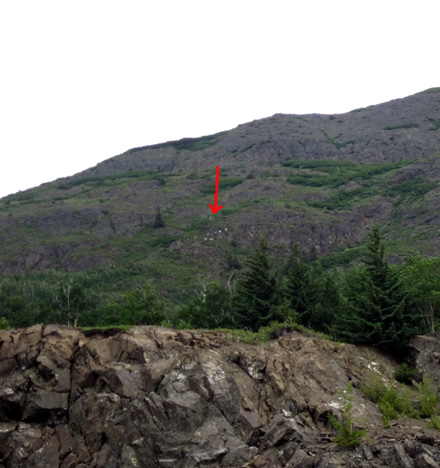
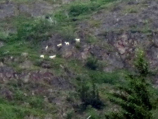
The sheep
were still there several hours later when we were going back to
Anchorage.
I barely got them with my old Canon camera – was wishing I had the new
one with 16x zoom and 16 megapixels.
If there’s room at this turnout when we have the camper with us on our
way to Russian River in a few days we’ll stop again to see if any sheep
are there. I hope I'll have better pictures for you later.
For the closest view of sheep, eagles, and whales there are some
powerful viewfinders at the overlook:

Beluga Point is a
popular overlook. Not only is it a prime sheep-viewing spot, it's also
reportedly a good place to see beluga whales in the water and bald
eagles in the sky. We looked for whales both outbound and on the return but didn't see any today. I don't think it's prime
time for them to be here yet and they don't come in unless the water is
deep during high tide.
Sometimes they get stuck in low water.
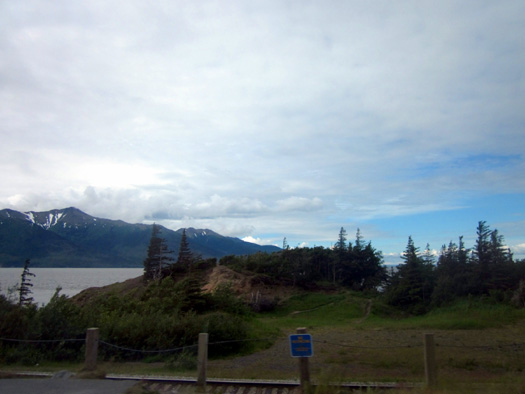
Several of the turn-outs along the Seward Highway also have trailheads
to hiking trails and
bike paths.
The trails look like they go straight up the ridges into Chugach State
Park. I’d like to check some of them out
later in the season. With all the melting snow right now they are
probably either a muddy mess
at the lower elevations or under snow higher up.
The bike paths are paved and run along one side of the highway or
another. A 3-mile path runs between the settlements of Indian and Bird; a 6-mile
trail connects Girdwood to Bird Point.
As you can see in
some of the photos on this page there
isn't much land between the water and the base of the mountains so the
highway, Alaska Railroad tracks, and bike paths run parallel and pretty
close to each other.
There are numerous waterfalls coming down the mountains on the north
side of the road. We could
see a few small ones from the road today. More are visible from the
trails going up into Chugach State Park and the national forest (Chugach
SP stretches for about 30 miles along this section of the Seward Hwy.).
Two creeks that we
passed before reaching the short road to Girdwood are very popular with fishermen -- Indian
Creek (MM 103) and Bird Creek (MM 101). We saw only a few people fishing in Bird Creek
today. I don't think the salmon are running yet.
GIRDWOOD & GLACIERS
At MM 90 we came to the Alyeska Highway, a two-lane road that leads back
three miles to the small town of Girdwood. This area is a popular
weekend retreat for folks who live in Anchorage and it has several
things of interest to tourists.
Girdwood was one of several towns in South Central Alaska that was
seriously affected by the epic earthquake on Good Friday in 1964. Like
Valdez, Girdwood was relocated to higher ground after much of it was
destroyed by the quake and resultant high tides (the town sunk eight or
nine feet).
Nearing the turnoff to Girdwood
The town of Portage, at the east end of the arm, was destroyed and never
rebuilt. Reminders include some abandoned buildings and the skeletons of
trees killed by saltwater.
All we did today at Girdwood was drive up the road to town, turn around at the Alyeska
Ski Resort, and go back down to the main highway. We looked at lunch
menus at two restaurants and were so dismayed at the prices that we just
ate the snacks we brought with us in the truck.
Consider yourself warned:
This house caught my
eye as we approached Girdood. On the way back out to the highway I asked Jim to stop so I could
get a better picture of it:
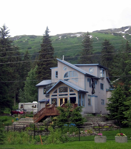
It has interesting angles, beautiful windows . . . and a motorhome out
back. Our kinda people.
I'd like to come back here another time to visit the historic
Crow Creek Mine, a National Historic Site, and maybe hike the Winner
Creek or Crow Pass trails. The latter is part of the famous Iditarod
Trail. Cyclists can use most of the Winner Creek Trail.
At MM 82 we got a good view of Spencer Glacier, one of several we were
able to see today on the south side of the Portage Valley. I think those
are technically in the Kenai Mountains:
Spencer Glacier
We were amused at
this "No Target Shooting" sign where the Twentymile River (MM 81) empties into Turnagain Arm near
Portage:
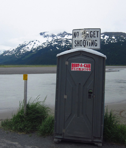
Obviously a tempting target for
miscreants
Twentymile River comes down from glaciers north of the highway in the
Chugach Mountains. It is
a popular place for dip net fishing.
PORTAGE VALLEY ROAD TO WHITTIER
We drove east on the access road to Whittier for about 5˝
miles to the Begich, Boggs National Forest Service visitor center
but didn’t go as far as the famous one-way tunnel where vehicles drive
for 2˝ miles on
railroad tracks through the mountain. We might do that another day.
The seacoast town of Whittier lies at the end of the access road about
11 miles east of the Seward Hwy. You can see its location on the map at
the top of this page.
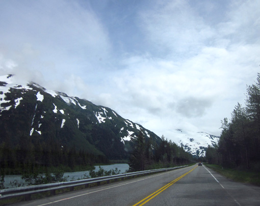
A little more blue sky on the road to Whittier
We
drove through the Black Bear NFS campground. It’s nice but most sites are
too small for us. Jim talked to a retiree at Potter Marsh who’s camped
at the nearby Williwaw CG. We didn’t go back to see it but should have.
It’s paved and has larger sites.
I’d like to stay at Williwaw on our way to or from the Peninsula so we can do more
along the Portage Valley Road than we did today. It's another very
scenic drive with views of hanging glaciers to the south and the
wetlands surrounding creeks and rivers to the north. The water is very
blue from lots of glacial silt.
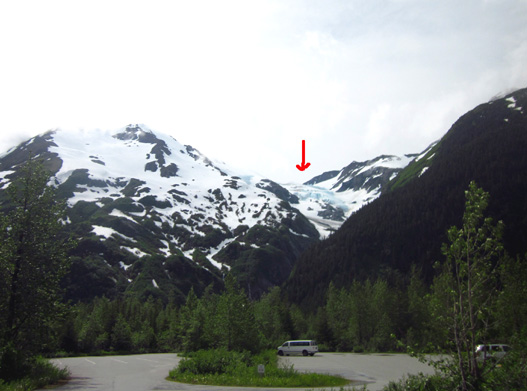
We could see this
blue hanging glacier from the parking lot at the Williwaw Fish Viewing
Area:
We also want to hike and ride our bikes on the five-mile long Trail of
Blue Ice.
From the road we could see portions of the trail and some handsome wooden
bridging over a creek and wet area:
Most of that trail is hidden from the road and more secluded than the
bike trails along Turnagain Arm.
We could also see Byron Glacier but didn’t know its name until
we got to the very nice NFS Begich, Boggs visitor center at Portage Lake,
about five miles back this road.
We stopped in the visitor center briefly and hiked a snowy hike back to
Byron Glacier. I'll show you pictures of that glacier and the pretty
blue icebergs in Portage Lake in Part 3 of this series.
BACK TO ANCHORAGE
By the time we got done hiking to Byron Glacier we were ready to head
back to Anchorage.
The sky was still cloudy to the north over the Chugach
Mountains . . .
. . .
but clearing over Turnagain Arm and Cook Inlet to the west.
It was quite
pretty when we got back to Potter Marsh, which we toured on the outbound
this morning when it was cloudy:
Next page: Potter Marsh wildlife refuge photos
Happy trails,
Sue
"Runtrails & Company" - Sue Norwood, Jim O'Neil,
and Cody the ultra Lab
Previous
Next
© 2012 Sue Norwood and Jim O'Neil
