[I can't vouch for this company but the professional photos are stunning
and I like the introduction on the homepage re: how gorgeous
Denali National Park is in autumn.]GOOD REMEDY FOR
CABIN FEVER
This was a quieter, more relaxed day for us after all the energy we
exerted yesterday. We both slept very well for almost ten hours last
night.
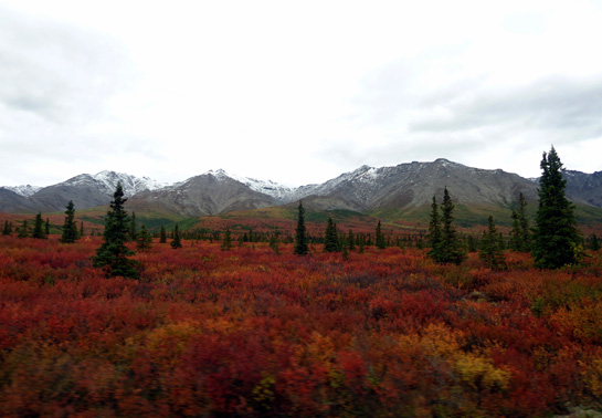
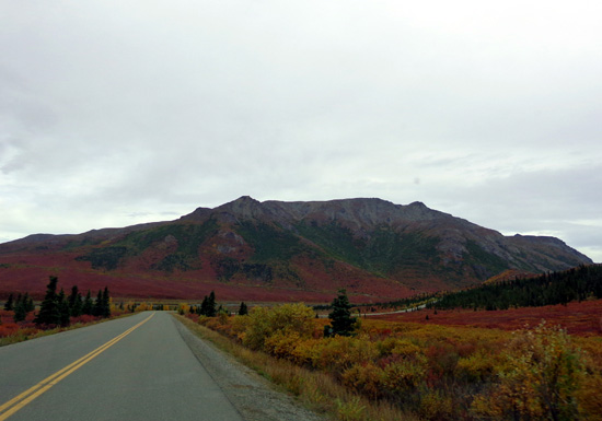
It was warmer this morning, with about one-third of the
sky blue when we got up. By 10 AM it was mostly overcast and a little windy. It
remained cloudy all day and evening, with temps reaching about 58 F. at
the campground. Most of the snow that fell earlier this week has melted,
although we could still see some snow on the peaks at about the
5,000-foot level:
If we'd known it was going to be nicer outside
in the morning than in the afternoon we would have gone cycling and hiking
at Savage River then instead of doing more inside things between
breakfast and lunch.
The photos in this entry are from our 15-mile drive out
to Savage River and my hike up to Savage Rock and along the river in the
canyon between Mt. Margaret and the west end of Healy Ridge.
We did get out to walk Cody for a mile in the
campground this morning. He got to meet the other campground host, Jim,
and his Labrador retriever, appropriately named Blackie. Blackie rides around the
campground in the golf cart when Host Jim is checking vacant sites, etc.
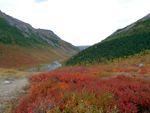
Above and below: Views of colorful foliage near the beginning
of the Savage Canyon loop trail along the river
I’ve already mentioned that many of the RVs in the campgrounds at Denali
are rental Class C motorhomes of various lengths. Folks with Class As,
5th-wheels, and travel trailers – and non-Alaska tags – are in the
minority here. (So are folks with dogs.) This time I’m guessing at
least three-fourths of the campers are rental units, more than earlier
in August.
Last evening we realized some of the folks in truck campers are also
renting them. There were three truck campers in our loop alone that had
“Let’s Go!” tags on the front. We didn’t realize those could be rented,
too.
I’m a little surprised how many children are still around. Alaska kids
are already back in school. Some other U.S. states resume classes after
Labor Day. I don’t know about schools in other countries; many of
the visitors to the park at this time of year are foreigners because the
price of airline tickets is lower now.
THE TRIP TO SAVAGE RIVER
After lunch we got
motivated to drive out to Savage River to ride our bikes and hike.
Jim considered riding the free shuttle again to Savage River and just
riding his bike back 15 miles to the campground from there. I thought
that might be fun, too, then had second thoughts because of the wind
from the south – that would be a crosswind most of the way and I’m still
a little tired from yesterday’s adventures.
Jim loves his rides on the park road, describing them as the most fun
he's had all summer. I still haven’t been on the roads on my bike here –
but the hiking trails are some of my favorites this summer, too,
so I came up with a tentative plan to incorporate both activities.
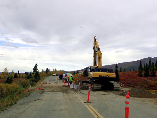
Still paving over the 200+ sections of the park road that were torn up
for new culverts
I suggested taking the truck to Savage River so I could do a ride-hike
combo. Jim had a good idea how I could do that.
Because the red colors on the hillsides west of the river are so
gorgeous right now he suggested that we could ride our bikes up to
Primrose Overlook 2˝ miles beyond the river/ranger station (where visitors can’t
drive their vehicles), look for Denali to the west (probably under
clouds today), take more pictures to the east, and ride back down to
the river.
Then I
could put my bike in the truck and go on a hike at the river while
Jim continued riding his bike back to the camper. That would give him 20 miles
today.
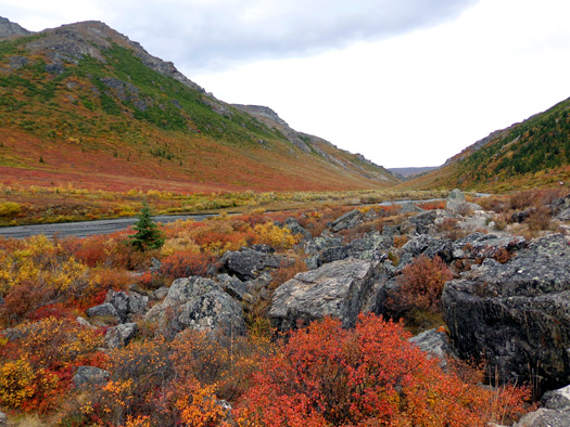
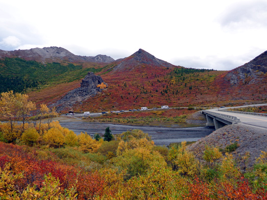
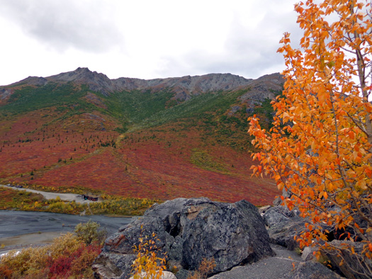
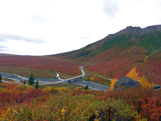
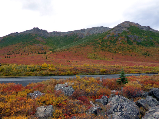
Approaching the Savage River; Mt. Margaret in background
When we got out there the wind was even stronger than at the campground.
The river is wide open to the south of the bridge and like a wind tunnel
north in the canyon, where the loop trail is located.
That's not so bad for
hiking but neither
one of us was inclined to ride our bike out there.
Jim took a nap in the truck and watched traffic in the rest area and the
bridge across the river while I hiked about 2˝
miles from two trailheads leading out from the parking area.
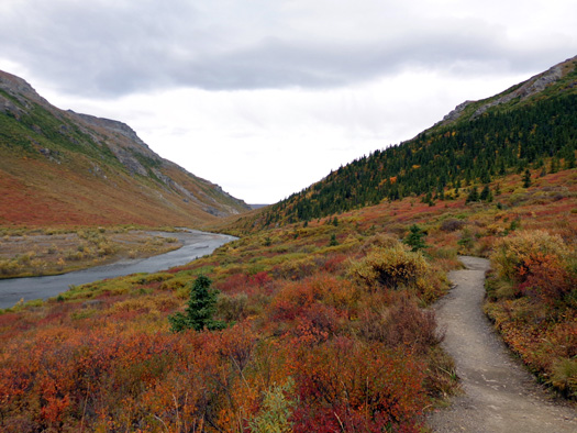
Here's a photo from
the other side of the river that I took at the end of my loop hike:
Jim's parked in one of those vehicles.
You can see Savage Rock just above the parking area, what I call Savage
Ridge (begins at the pointed peak in the center above Savage Rock), and
the west end of Healy Ridge (background left). The canyon loop
trail along the river is out of sight to the left.
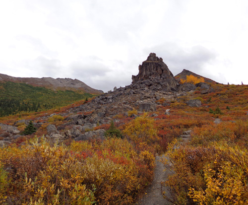
VIEW FROM SAVAGE ROCK
First I followed the trail up
the rocky slope of the mountain east of the river above the main
parking lot. (There's another parking area on the other side of the
river.)
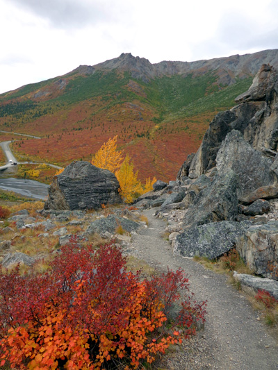
It's about a quarter mile ascent to the first rock formation, which is
called Savage Rock:
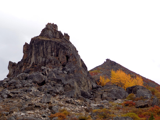
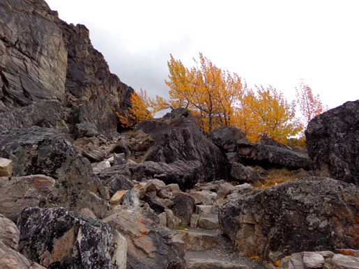
I did a long hike up into the alpine bowl above Savage Rock
several weeks ago when some of the leaves were just starting
to turn color. The trail continues for over a mile past Savage Rock.
Then it's easy to just wander around the tundra.
This summer workers are building new trail there that will connect to
the Savage River Campground about three miles east of the river.
Today this slope looked so beautiful from the road that I wanted to get
right up into some of the colorful leaves. I took the next three
pictures part way up the trail:
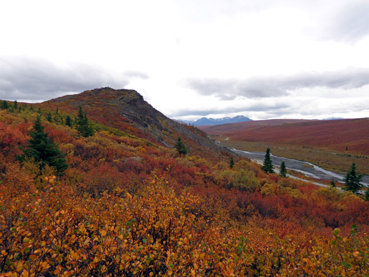
View to the southeast
View west to
the bridge and SW end of Mt. Margaret's ridge
Same
direction, from a little higher up
I took the next three photos near
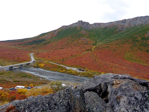
the "landing" at the top of the rock formation and on my descent:
View north
from the "landing" down to the river canyon loop;
I was about
200 feet above it when I took that picture.
The whole
valley to the left of the road (south) is a burgundy red color.
You can see
where those bright orange, red, and burgundy colors
in the
valleys and on the mountainsides come from.
This trail is rocky
and moderately steep. One or two trekking poles are helpful if you're
over 50. <wink>
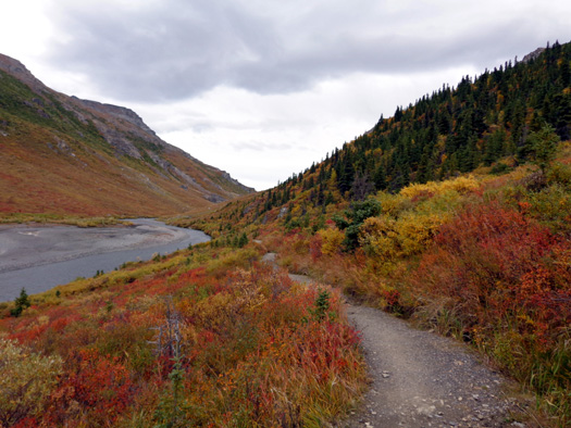
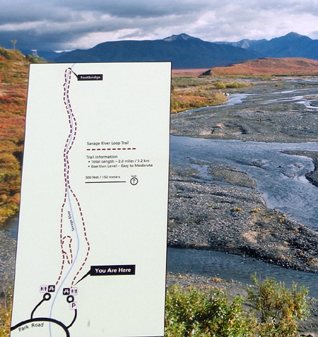
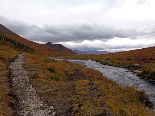
SAVAGE CANYON TRAIL
Next I hiked the more level two-mile loop on either side of the river.
I started on the east side ("You Are Here" on map below),
hiked a mile into the canyon, crossed the
footbridge, returned on the west side, and crossed back over to the main
parking area on the long vehicle bridge across the Savage River.
This map of the loop is from a sign at the rest area:
There were some other folks out on the trail but not as many as when I
did the loop and farther down the canyon
two weeks ago.
View west toward
Mt.
Margaret where I also hiked a couple weeks ago
I noticed even more color change at the elevation of the river -- about 2,780 feet.
The terrain was mostly green when I hiked this loop previously and much more red and orange
today.
The next three photos
are also near the beginning of the loop trail on the east side of the river:
Last time I hiked on this trail there was a
handsome male
caribou on the
gravel bar to the left. I didn't see any wildlife
today, unfortunately.

Above and below: looking back south to Savage
Rock

The broad
riverbed quickly narrows after the gravel bar. You could jump across it
in some places.
Even though the
stream is going downhill slightly, gathering both momentum and more
water from the mountainsides, it looks more like a creek than a river
after about a third of a mile:
The stream
bed narrows to just a few feet here. Note the new trail to the left
and the old
trail very close to the creek, er, river.
At this time of year
there is minimal water in the river. When the winter snows are at peak
melt the riverbed is probably full (it obviously has been at some time
in the past) and the more narrow part of the channel overflows.
Apparently it flooded
earlier this year and damaged and/or destroyed parts of the trail loop.
About half of the trail has been relocated a little higher above the
river this summer.
The same crew of about a dozen young men and women that I saw earlier in
the month continue to work on this project:
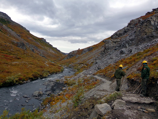
The new parts of the trail appear smoother but muddier than the old ones.
The crew has not only cut out the trail and relocated the tundra
soil/plants to the old parts of the trail, they have also done a lot of
erosion control with ditches and rocks.
The next photo shows
the bridge across the river as it approaches a more narrow part of the
canyon:
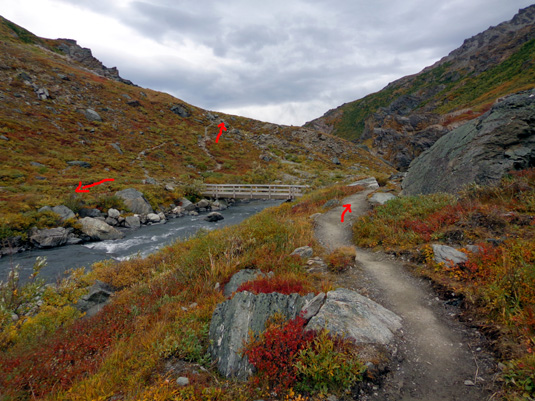
Today I turned left over the bridge and came back the other side of the
stream. The last time I followed the "up" arrow along a more gnarly
trail through the canyon, gradually gaining elevation until I was at
least a hundred feet above the water.
Someday I'd like to go farther into the next valley where the Savage
River drains -- and/or up Mt. Margaret's slope from this area to
her long ridge that parallels the river.
Continued on the
next page because I have more colorful
fall photos to show you from this hike . . . with captions
but minimal other verbiage.
Happy trails,
Sue
"Runtrails & Company" - Sue Norwood, Jim O'Neil,
and Cody the ultra Lab
Previous
Next
© 2012 Sue Norwood and Jim O'Neil
