(Continued from last page)Our friend Roy does not know what an
obstacle is; he loves to solve problems. He does his best to outwit the curveballs (and
boulders) life
throws his way and he usually succeeds.
Jim and I are wired a lot like that, too, so we had great fun on today's
Jeep trip with Roy, his wife Laura, and their friends Bob and Lalani as
we continued exploring Cunningham Canyon.
I'll get to the "obstacle" part in a little bit.
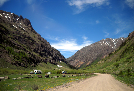
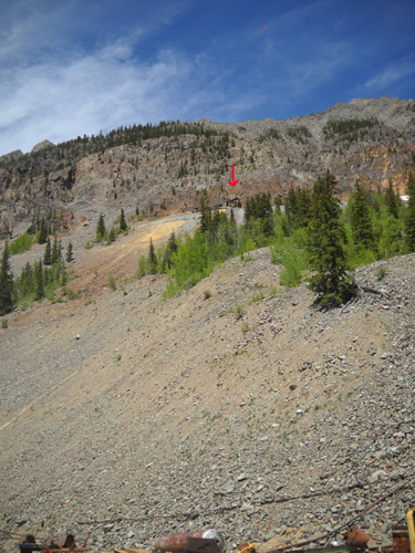
LOCATION OF CUNNINGHAM AID STATION
When we were done eating lunch we continued farther back the road through the
gulch. Nearby is the site Hardrock uses for the Cunningham AS.
Several RVs are camped there now. I took this picture on our way back
out of the canyon:
After another quarter
mile we came to a waterfall, an old mine site, and a parking area that
is currently buried under snow.
This is where the
road becomes more difficult for a 2WD vehicle.
Last year we parked the truck there and just walked up
the road about half a mile to access the trail we hiked through the
Weminuche Wilderness to reach the Continental Divide.
NOW WE'RE HAVING SOME FUN!
Today, however, Roy and Bob
kept on driving their sturdy little Jeeps up this
more narrow, steep, and
rocky 4WD section of FSR 589. In about a mile we passed a parking area and a little road
to the trailhead up to Highland Mary Lakes. That's as far as Jim and I
have ever driven up this road when we had a 4WD truck.
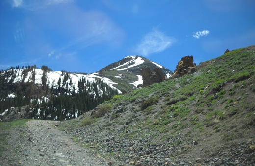
We continued to an overlook at about 11,500 feet elevation with scenic
views all around:
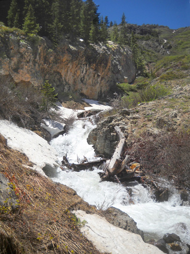
The road ahead
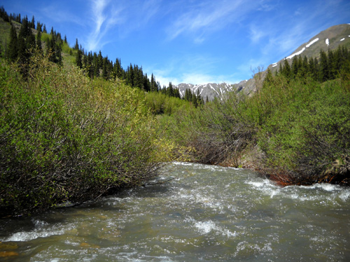
Right after this overlook the road crosses Mountaineer Creek
and continues up, up, up until it finally ends somewhere in a high
basin beneath 13,400+ foot peaks.
We haven't seen the creek up here before but I'm guessing it's
flowing higher and faster than usual for late June because of the
copious amounts of snow that fell during the winter. There is still some
snow on the banks here at about 11,700 feet:
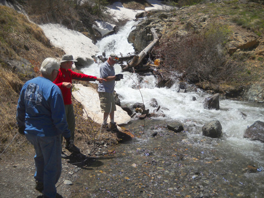
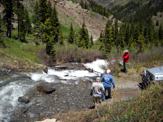
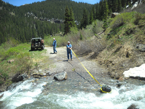
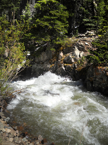
While I was taking pictures the guys got out to inspect the creek crossing,
our first real road obstacle of the day:
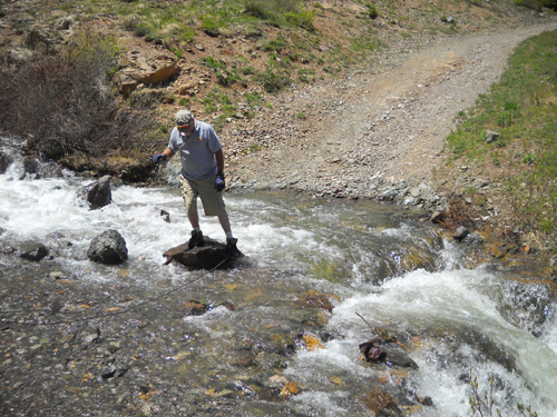
I think Roy was happy to have finally found a challenge!
These rocks don't look all that big but Roy and Bob knew their vehicles
didn't have high enough clearance to ride over them without
high-centering. Nor did they want to drive to the right because there is
another waterfall on that side of the road and it'd be easy to slide
over it, considering how fast the water was flowing.
The guys decided to move the rock Roy's standing on in the picture
above. They wanted a space large enough in the middle of the road to
drive the Jeeps between the rocks.
After tugging on the rock they quickly ascertained that they couldn't
move it with brute force.
Like most adventurous Jeep (and truck) owners, Roy carries a steel
cable or tow rope for such occasions. The guys got to work
fixing a loop around the rock they wanted to move:
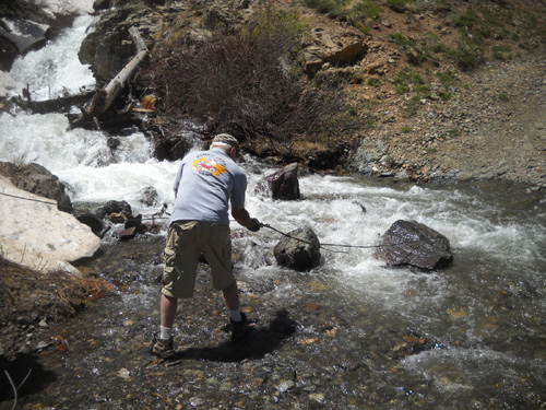
After securing the ends of the cable to the front of his Jeep, Roy asked
Laura to slowly back up the Jeep:
It took a couple tries because the cable slipped off the rock the first
time. Roy secured it a little differently the second time and Laura was
able to pull it far enough away from the rocks on the left to drive the Jeep between them:
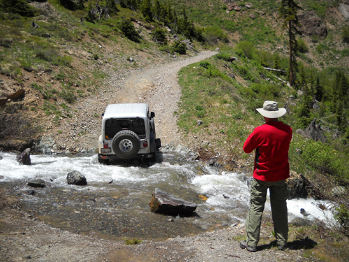
Astute readers will note that Jim and I were not in the Jeep when Roy
drove it through the creek.
Keep in mind that we are not Jeepers. The creek may look pretty tame in
these photos but it was moving very fast, the rocks were slick, and we
didn't want to go down that waterfall on the right! Roy can be a bit of
a daredevil and we were skeptical of his ability to get that thing safely
to the other side of the creek.
We underestimated him.
We watched as Roy carefully maneuvered through the rocks and slowly
climbed the steep little embankment on the other side. Good job! Then we
walked through the water and got in the Jeep for further adventures
farther up the road.
After seeing how hard it was for Roy to maneuver
his vehicle through the water Bob and Lalani decided to remain on the
other side and waited for us to come back down. (See, we weren't the only
skeptics.)
We weren't two hundred yards up the road when we ran
into the next problem -- more rocks:
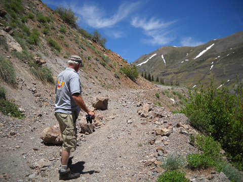
Those were easier. Roy, Jim, and I were able to move several of them by hand far enough to safely
drive by on the right without going over the cliff. I was on that side
and just looked the other way as Roy moved ahead with two tires close to
the edge on those loose rocks.
By then I was wondering if Jeeping is always this much work . . .
I mean fun.
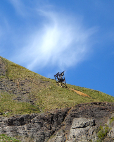
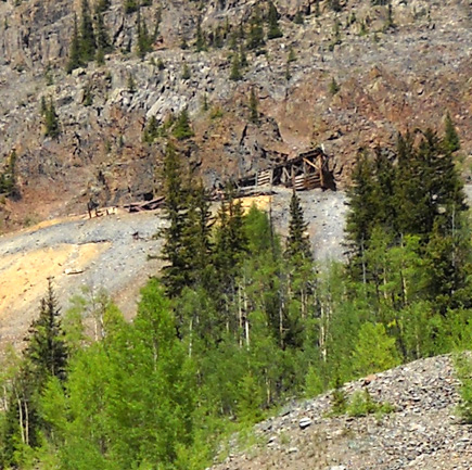
We continued upward past a relic of an old mine sitting 'way up high on
the mountainside:
The next switchback was full of snow. Roy got
through it with some difficulty and was bouyed by his success. With each
obstacle conquered, he was more determined to keep going up the mountain
as far as possible.
With his perseverance I think he would have made a good ultra runner
when he was younger!
Unfortunately, the
next snowdrift was too deep to surmount except on foot or perhaps a
little ATV. Roy made repeated
attempts to get up and over it, but even in the Jeep it was too steep
and risky.
This road isn't cleared like it usually is by late June, either by Mother
Nature or the Forest Service. The Forest Service does plow drifts
sometimes on roads in the San Juan National Forest but I don't know
if they ever clear this road.
Roy had to turn
around at about 12,000 feet and go back down, but not before teasing me by driving right to the edge of the gravel road, front
end hovering over a cliff, and honking to get Bob's and Lalani's
attention 'way below!
I was in the front
seat and all I could see was sky out the windows. From the back sear Jim
and Laura couldn't see how close we were to the edge. Roy was laughing
his head off.
I am sooooo glad Jim
never pulls stunts like this! Poor Laura.
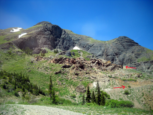
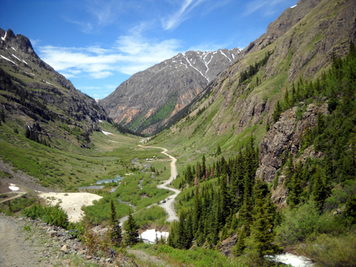
WHERE WE WERE
Here's a good
perspective of the terrain between the creek and the upper road where we
had to turn around. I took
this picture in early July last year while we were hiking up to the
Continental Divide on a mountain to the north:
Overview of our
location, taken July 2010 from another perspective.
#1 is where the fellas moved the rock out of the Mountaineer Creek
crossing. #2 is farther up the road where we started running into
problems with snow (part of the road is out of sight to the right). #3
is farther up toward the basin where we had to turn around.
Someday when there is less snow on the ground I want to drive or hike up to that basin.
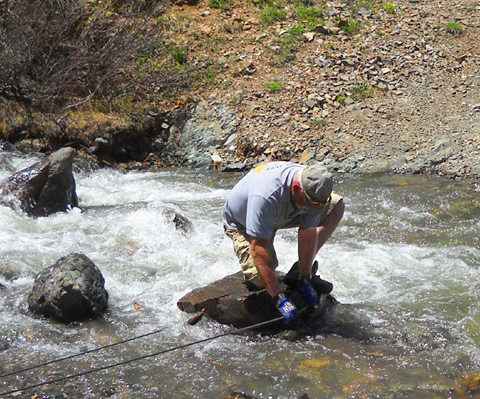
While Roy, Laura, Jim, and I were gone up the road, Bob and Lalani tried to pull another smaller rock out of our way
with their tow rope so it was easier for Roy to cross the creek when we got back:
They weren't able to move it by hand, however. In the picture above,
Lalani is holding the tow rope while Bob gets the Jeep to help move the
rock. Roy said he could get through OK so they gave it up.
TRAIL TO HIGHLAND MARY LAKES
When we got down a little farther I asked Roy to go back a quarter mile
or less to the trailhead to Highland Mary Lakes.
We had to cross Mountaineer Creek going in and out.
The creek was more narrow here so
the water was considerably higher in the middle -- and still
running fast. We couldn't see the stones on the bottom of the creek in
the center to accurately gauge the depth. Roy
guessed the water was about two feet deep at most.
He thought it might come into the floor of the Jeep but he
plowed through it anyway; no water got inside but that added to
some excitement today.
Jim and I stayed in the Jeep both those times because there weren't any
waterfalls to go over! I took this picture coming back out:
Bob and Lalani followed with some trepidation. They know the risks Roy
is willing to take.
All six of us got out of the vehicles again at the trailhead to wander around
and take more pictures. We read the Weminuche Wilderness sign and Roy got some
snow to keep the drinks in his cooler chilled.
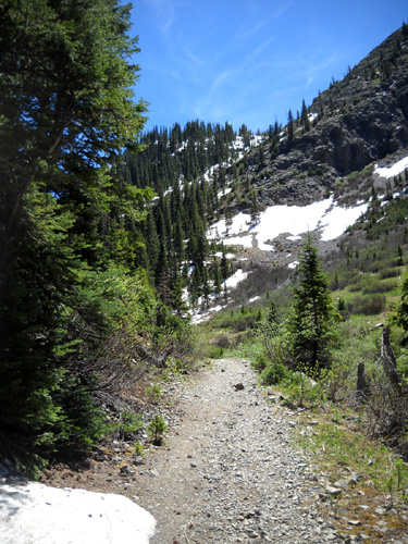
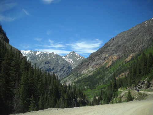
Start of the trail up to Highland Mary Lakes
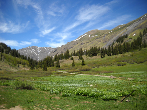
View from the trailhead back down the canyon
I’d like to hike up to Highland Mary Lakes while we're here this time;
they are a popular hiking destination and someplace new for me to
explore.
We drove back out
across the creek and still didn't get wet although the water was lapping
at our doors.
Farther down into the
canyon both the road and creek drop 300-400 feet in elevation to the
old mine at the end of the good part of Cunningham Road (FSR 589). I
love the series of waterfalls and cascades along this section:
At some point Mountaineer and other streams coming down from the Continental
Divide merge into Cunningham Creek, which you can see in this scenic
overview of the valley below us:
The large white spot in the lower left is mine tailings. In the center
of the picture you can see white specks that are RVs parked at the site
of the Cunningham AS.
The road continues in the background toward the Old Hundred Mine.
I took this photo going mostly north toward the mine:
Years ago Roy and Laura climbed up a narrow rocky trail to an old
boarding house used by the miners. It's at about 12,000 feet elevation on the
mountainside on the right but this photo is too small to see it. I'm not
very afraid of heights (when I'm in control and not at the mercy of
someone else!) so I think I'd enjoy hiking up to this historic building.
There just isn't always time to do everything I want to do when we're
here.
I'm always amazed by and respectful of the hard-rockers (the original
ones) who not only worked in such precarious surroundings but also
helped haul materials high up these mountains to install mining
equipment and build structures.
That was long before the days of OSHA, of course. Imagine all the
regulations and lawsuits there would be today! Many men died trying to
make their fortunes in mines across the West.
Roy drove the "high road" past the Old Hundred mine on the way back to town. He and
Laura have taken the tour previously; Jim and I haven't done it
yet. There's a lot of interesting history from this mine, one of many
that flourished in the 19th Century.
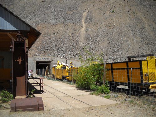
A group gets ready to enter the mine on a tour.
POST-JEEP RIDE THOUGHTS
We went through a deep creek twice, up and over rocks, and through a bunch
of mud and snow. We saw new scenery that we can't access with our 2WD
Dodge truck.
Great fun, we thought. Now how can we manage to travel with a Jeep???
That won't happen anytime soon, I'm afraid. We'd need a motor home to
pull it. Our truck isn't strong enough to tow the Cameo and a "toad" behind
it, nor would that be safe or practical because of the length of three
vehicles. If we need another Jeep
fix we'll either have to bum a ride with friends who have one or shell
out the bucks to rent one.
There are many little dirt 4WD roads and tracks through the San Juans.
The ones we were on today are rather tame in comparison to some we drove
several years ago when we had our 4WD F-250. Sometimes we had to back up on tight
switchbacks and get halfway off the road when we met other vehicles.
There were times we had difficulty gaining enough traction on loose rock
or snow to get up steep grades.
Some of these roads and tracks are definitely easier in a Jeep.
Above and below: not the boarding house, but
another
structure high above the Old Hundred mine.
One of the roads I'd love to ride up again is FSR 737, an offshoot
from the road through Cunningham Gulch that we were on today.
It branches off to the north after the Old Hundred mine and begins a
steady climb to Stony Pass at the Continental Divide (about 12,000
feet). I'd like to use it to get to the trailheads for Colorado Trail
Segments 23 and 24 so I don't have to hike up from the end of Cunningham
Gulch, but I'm not likely to go up there in the next two weeks unless a
bunch of snow melts by then.
FSR 737 to Stony Pass is rough, has tight switchbacks, and is probably
impassable even in a Jeep right now unless the Forest Service has plowed
it. Even if it was cleared I wouldn't try it in a 2WD vehicle unless
you're in a rental! It'd be great fun in a Jeep. It continues in better
shape along the Rio Grande over to Creede as FSR 520.
If you ever visit
the San Juan Mountains in the summer, do go for one or more rides in a
Jeep. It's a lot more fun than we thought it would be. Thanks, Roy and
Laura!
RELAXING AT HOME
When we got back to the campground in
the mid-afternoon I took a nap (very unusual for me) and Jim read his
new book, SEAL Team Six, for a couple hours. He often falls asleep while reading but
he was so engrossed in this book that he was still wide awake after
reading more in the evening.
Must be a good book! I'll read it when he's done.
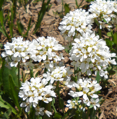
Perky spring flowers near the Highland Mary Lakes
trailhead
We went to the Stellar Bakery and Pizza restaurant for supper, arriving
about 5:45 PM to an empty dining room. We thought it would be more
crowded. It took a while to get our Mediterranean pizza, however,
because of a large take-out order (six pizzas) before ours.
We ordered a 16” pizza for a pricey $20; there are enough
leftovers for a second meal. We
should have gotten a $10 eight-inch pizza. The pizza was good but not
as good as the pizzas we get at High Mountain Pies in Leadville.
A local woman started up a conversation with us while she was waiting
for a pizza to go. She lives near Carolyn and Eric Erdman so we talked
mostly about them and the race. She told us about a “senior group” that
is hiking the Hardrock course over a period of several days after the
race. Too bad we won't be here long enough to participate in that.
Next entry: beautiful scenery on my hike to Clear Lake
Happy trails,
Sue
"Runtrails & Company" - Sue Norwood, Jim O'Neil,
and Cody the Ultra Lab
Previous
Next
© 2011 Sue Norwood and Jim O'Neil
