I love the wide variety of trees and other plants at Brazos
Bend! They are a result of the unique mix of eco-zones
within the park: the bottomland hardwood forests, wetlands, and
upland tall grass prairies that I talked about in the last
entry.
Here is a picture of a tactile relief map in the Nature
Center that shows the relationship of these three eco-zones. Woodlands are green,
marshes and wetlands are light blue, prairie and grasslands are tan, and water is
medium blue:
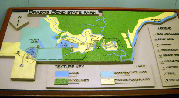
The park entrance is to the left, campgrounds are the loops in
the center, and the Brazos River is on the far right. Big Creek
winds diagonally through the park and empties into the river at
the lower right (SE) corner of the park. That's where the Red
Buckeye Trail is located (most of the trails aren't shown on the
relief map).
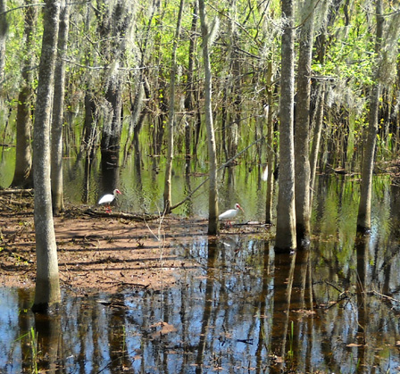
It was fun to pass through the various vegetative zones each time we drove, walked, ran, or biked through the park. Huge live oak trees
dripping with Spanish moss here . . . marsh grasses with
herons and ibis feeding over there . . . a field full of
yellow buttercups nodding in the breeze up ahead . . .
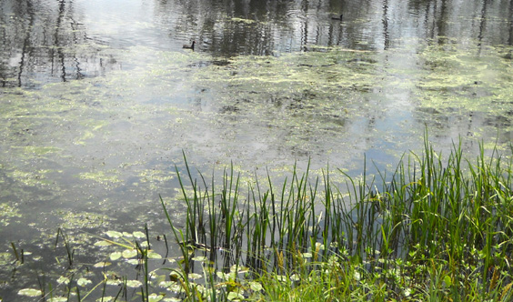
This is my "Monet painting" shot of
some aquatic grasses
along Elm Lake.
It was also fun to
watch the amazing transition of the leaves and flowers from early to
late spring in the span of just four weeks. It makes we wonder
what the park looks like in each of the four seasons.
Each day brought new surprises as we explored the park. My
senses of awareness have been heightened all month! Come along
and I'll show you some more of the park.
1. THE WOODLANDS
Changes in elevation of only a few feet mean significant changes
in the woodlands at Brazos Bend State Park. It reminds me of the
different eco-zones through which I've passed going up and down
in the Appalachian and Rocky Mountain ranges, except the changes
at Brazos Bend occur over much smaller increments in elevation.
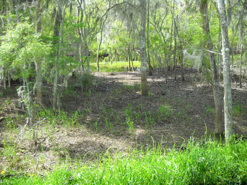
The river bottomland and some areas along Big Creek
support mixed hardwood vegetation including pecan, elm, sugar
hackberry, various species of oaks, and numerous species of
shrubs and vines. These are easily seen along the Red Buckeye
Trail in the southeastern corner of the park where the
elevations are lowest:
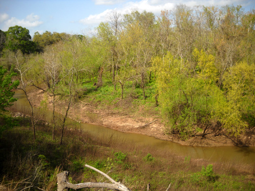
"Gallery" forests along the river, creek banks, and bayous are
dominated by sycamore, cottonwood, and black willow
trees. This is a view down to Big Creek in the NW corner of the
park at the end of March when the creek level was lower:
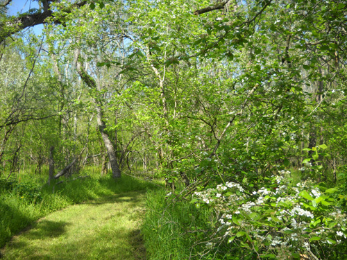
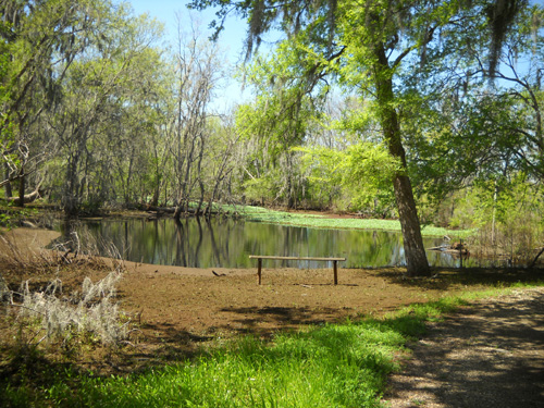
The elevation is a little higher in the old "meander escarpment" of the river.
These areas, characterized by
magnificent moss-covered and vine-draped live oak woodlands, are especially noticeable near the park entrance, Hoots
Hollow Trail, and 40-Acre Lake picnic area (below):
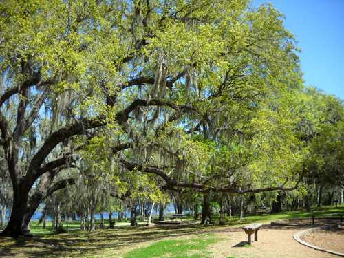
The oldest live oak in the park has been dated back to 1782
-- that's 228 years ago! There are several others that are
about 200 years old.
The green fern-like plants growing on the limbs of this live oak are
called Resurrection Plants:
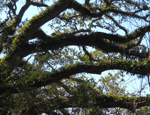
They look brown when it's been dry for a while but perk right up
and turn green when it rains.
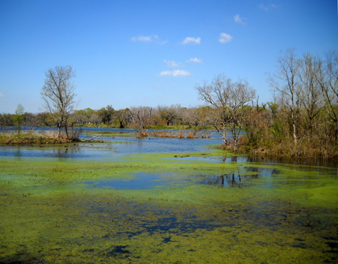
2. THE WETLANDS
Brazos Bend State Park contains a lot of water, especially
during the winter months -- so much, in fact, that this
week the rangers have been draining the large swamps!
This ritual routinely occurs in March. This year the large area
on either side of the entrance road (including Pilant Slough)
was drained between Spring Break and Easter, the two heaviest
weeks for visitors in the park. Pilant, 40-Acre, Creekfield, and
Elm lakes all looked a few inches lower after four days, too.
There is some odor involved when
the near-stagnant water is released and the muddy soil and
waterlogged plants are suddenly exposed to the air, so the staff
tries to minimize the impact on visitors and do the job when
fewer visitors are there.
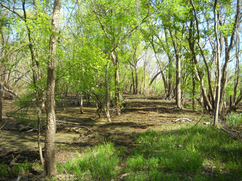
Here's a typical "before" picture of the swamp on the other side
of the levee from Elm Lake:
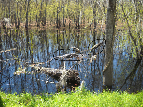
For most of March the water was very close to the trail. On
sunny days
alligators often crawled up onto the grass right next to people
walking by. In the photo above, there are two juvenile 'gators
straddling logs in the water instead of lying in the grass;
I circled them.
There are at least two reasons why the swamp is drained:
so the trees and other vegetation that get flooded each winter
don't die -- they need some air and sunshine --
and to allow flooded trails like Pilant Slough and Live Oak to
be opened up. The Pilant Slough, Bayou, and Sawmill trails were
closed until a few days ago. They are still too wet for
anything but foot traffic.
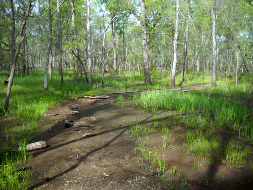
This low spot on the Pilant Slough Trail
had just drained and was still muddy for about
fifteen feet when I walked the trail for
the first time recently. It dried out in a couple days.
Two miles of Live Oak and three-plus miles of Creekwood trails
are still impassable, even for foot traffic. We haven't
ventured very far into either one of them because they are just
too muddy.
Part of the Live Oak Trail that parallels
the park entrance road:
just drained and still too muddy to use
when I took this picture.
Draining the swamp should open up all of these trails to
pedestrians, cyclists, and equestrians in a few days unless
there is heavy rain in April and May. I guess we'll have to
return in the fall sometime (after it cools down from the
summer heat) to see the trails we missed this month.
The drainage process took about four days this past week. The flood
gates were opened (literally!) behind the Nature Center where Pilant Slough flows under
a park road and
runs about a quarter mile down into Big Creek. This picture
shows the two drains that were opened; water is still
flowing through the one on the left but is below the level of
the pipe on the right:
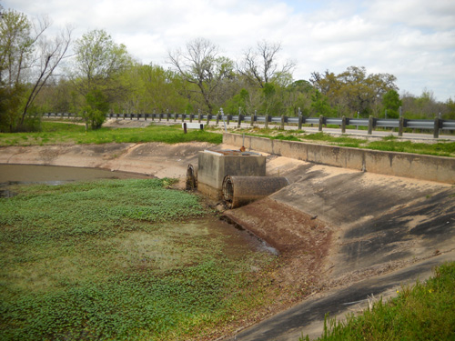
The old water line indicates the water level has dropped about two feet.
This is what the water looked like on the other side of the road when it
was gushing out:
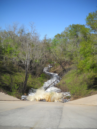
Pretty cool, huh? (Stinky, too.) Before the flood gate was
opened it was dry down there.
After only one or two days we could see the water level
receding along the park entrance road ("The Longest Mile"), Pilant Slough Trail, and the swampy area on the south side of
the Elm Lake levee. It was interesting to watch the changes each
day and wonder
just how many gallons of water were going through those pipes
every hour! We're talking about a thousand acres -- or
more -- of wetlands being drained.
Yum! New food sources!
After three or four days the water was down between one and two
feet in different areas. Not only was more land exposed, the birds and other
wildlife went crazy with additional food sources like worms and
insects that were suddenly exposed
(above).
Water covered this area next to the Elm
Lake levee three days before I took this photo.
The soil is already drying out. Grasses will probably cover
the area
in a few weeks.
I had two surprises when the project was completed after four days of
draining the swamp.
First, this bench near the
intersection of the Elm Lake and Pilant Slough trails was
finally high and dry (or it will be when the mud dries out). For
several weeks I could see it from the Elm Lake Trail. It looked funny
sitting out in the pond! Water covered that brown area
and parts of the trail until a few days before we left to
head farther east:
An even bigger surprise, however, was what the water under the
Spillway Bridge looked like after Pilant Slough was drained.
Here's a "before" shot from the long wooden bridge:
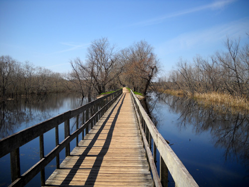
To the left is Pilant Slough. Less than a quarter mile ahead is
the observation tower and 40-Acre Lake. To the right is Pilant
Lake and the huge marsh area I showed in a previous picture.
Some of that area drained but not as much as the swamp to the
left.
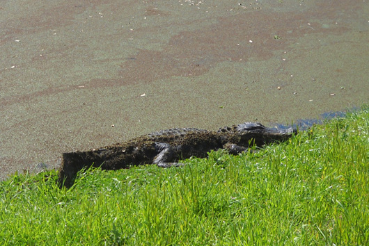
Here's what this spot looked like on the fourth drainage day:
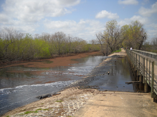
Bridge across the Pilant Spillway
The other side looked similar.
Note the six-foot alligator on the concrete (lower left side of
photo above). I wonder where his buddy is? Every time I went
across the bridge there were two of them near that very spot and
occasionally a third one at the other end of the bridge.
I love the wide variety of trees, grasses, colorful red and
green algae and aquatic plants that float on the surface of the lakes, sloughs,
and marshes, and other things that grow in these wetlands. Here
are some more examples:
Elm Lake, near a fishing pier
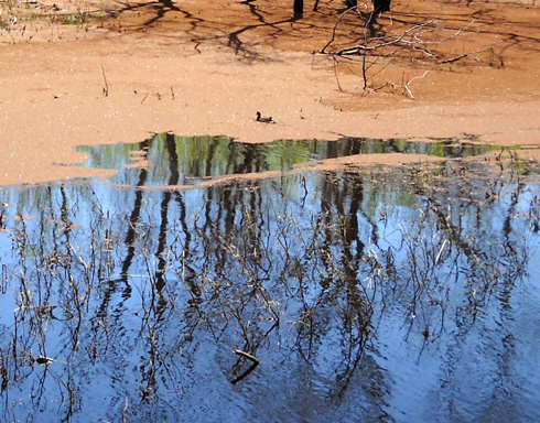
A duck floats through some reddish aquatic plants floating on the surface of Pilant Slough.
Our first alligator sighting! This big
fella sunning himself next to the water near the Nature Center
was partly covered by the greenish-reddish
plants floating on the surface of the water.
There is one other major ecosystem represented within Brazos
Bend State Park:
3. THE TALL GRASS COASTAL PRAIRIES
The prairie "uplands" in the park were formed long ago when
water covered much of what is now southern Texas. When the water
receded the last time, huge grasslands grew all over this area
of Texas and the Plains.
The grass supported millions of buffalo until the vast herds
were mostly decimated. More recently, cattle grazed on the
prairie land in what is now Brazos Bend State Park.
Because so much natural prairie land has disappeared with the development
of farms, ranches, industry, and urban areas
in Texas, the state has set aside some protected areas such as
those at Brazos Bend. Park staff work to conserve and restore
what is left of this vast ecosystem so visitors can enjoy at
least some small communities of tall grass prairie.
The largest area of prairie that is open to visitors
is near the park entrance. There is a short, flat trail across from
the parking area for 40-Acre Lake that leads to a covered
observation deck under a sprawling shade tree:
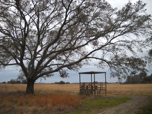
Nearby is a boardwalk leading to a wet area.
Wet area??
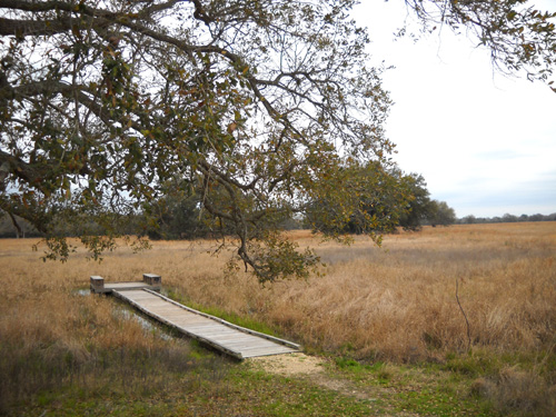
The Little Pond on the Prairie
That surprised me. I figured the prairie would be dry,
even in March. Nope. Coastal prairies typically have lots of
swales and depressions that become ponds during periods of heavy
rainfall. I imagine this wet spot is dry in the summer.
I'd also guess the prairie is prettier in the summer when the
grasses are fully developed and more colorful. Or maybe
not. At
the end of winter it was definitely "quiet and subtle," as the interpretive
guide diplomatically
describes it. I probably would have enjoyed my prairie walk more
if I'd taken the time to sit on the bench at the observation
deck and
watch for wildlife. I did see several deer run away as I walked
in on the approach trail. They might have returned if I'd been
sitting still for a while.
Next entry: some of the beautiful flowers blooming in the
park in March
Happy trails,
Sue
"Runtrails & Company" - Sue Norwood, Jim O'Neil,
and Cody the Ultra Lab
Previous
Next
© 2010 Sue Norwood and Jim O'Neil
