This entry is all about movement: hiking or running up a
scenic mountain road with interesting views all along the way. You could
get the benefit of movement on a bike but you'd surely miss more of
the scenery and details that way.
Just about exactly three miles west of our campground on South
Mineral Creek Road there is a
little 4WD road (FSR 815) going up to Clear Lake, a beautiful alpine
lake I've featured in this journal previously:

The road is 4.4
miles long and rises at a moderate grade from ~ 9,750 feet to ~ 12,000
feet elevation.
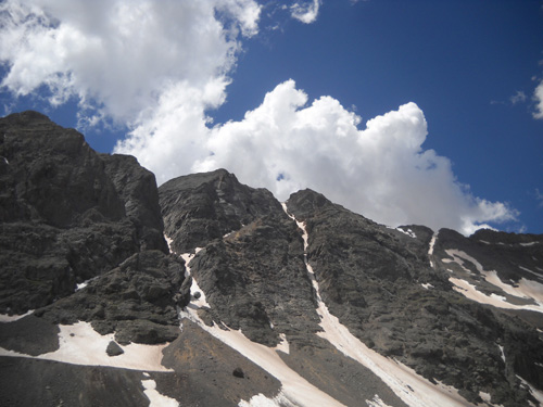
If you climb one of the slopes above the lake, as we did
several years ago (right into a storm!), you can get up even higher. I
took this photo from the north ridge in
July, 2006:
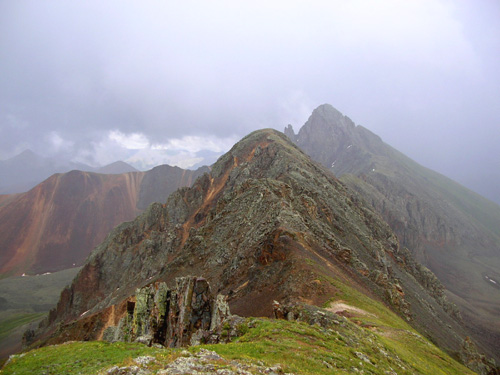
Into the storm on 7-6-06: not the best idea in the
world, but the views were dramatic!
If I'd remembered how pretty the canyon is on the other
side, I would have climbed back up there sometime since -- when
the weather was better, of course.
It's not called Paradise Basin for nothing!
This next photo
is from the same day in 2006. Paradise Basin is just east of and parallel to
Swamp Canyon, the gulch Hardrock
runners go up or down (the loop course reverses direction each year) between Grant-Swamp Pass and
the Chapman aid station:
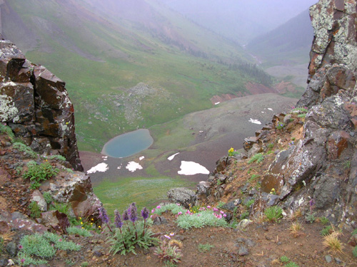
Looking down into misty Paradise Basin just east of South
Lookout Peak and Grant-Swamp Pass
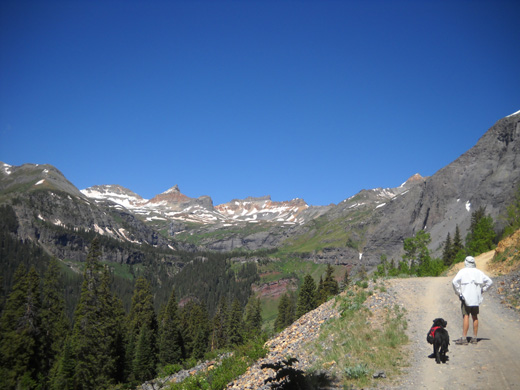
VARIATIONS ON A THEME
Over the years Jim and I have done various combinations of runs/hikes
from our campground on South Mineral Creek Road and the road up to Clear
Lake. The total distance round trip is just under fifteen miles.
When we want to run or hike less, we drive the truck three miles to a
little parking area at the beginning of the Clear Lake Road. Up and back
gives us almost nine miles. That's what Cody and I did today.

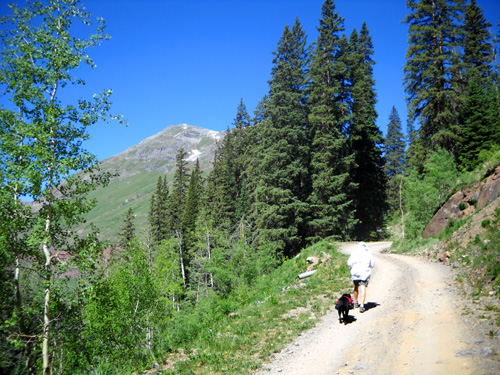
Cody and Jim head into the aspen
zone from about 9,800 to 10,500 feet elevation.
Jim added a different twist by hiking up with us, then running back
down Clear Lake Road (Cody and I walked down so my knees didn't suffer).
Then Jim kept on going past the truck, running an additional three
miles on South Mineral Creek Road to our camper, for a total of almost
twelve miles. I drove the truck back when I got down to SMC Road.
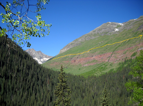
I marked part of the Hardrock course in yellow on the picture
above:
there are many good views of the Kamm Traverse (KT) from
Clear Creek Road.
That may not sound like a lot of distance for either of us but we
aren't acclimated to 12,000-foot elevations yet! This was quite enough
for our first real training run/hike here.
Higher up the road, the aspen
groves morph into pine forests.
There's a fair amount of shade
until you reach timberline.
My hike took about four hours, including a 20-minute stop at the lake
to enjoy the stunning scenery. It also includes the time it took me to
take lots of pictures.
Jim started back a few minutes earlier
and got done quite a bit faster because he ran almost all of the last 7˝
miles.
PHOTOS FROM TODAY'S RUN/HIKE
All the photos in this entry except the two cloudy ones I took in
2006 are ones I took today on the way up to and down from Clear Lake. We
had great weather and few to no clouds -- until we reached the
lake in the basin at the top of the road.
Fortunately they weren't rain clouds like we sometimes encounter up
in the basin, just the billowy white kind that add interest to the views:
Most of the photos in this entry except the flowers are in order
going up, then down. They are not in the order I took them, however. I
took a lot more when I was alone on the way down, and those have more
clouds in them.
Because there are so many pictures I want to show you, I'll put them
on two pages. I took a whopping 236 photos in almost nine miles of
walking (don't tell Jim!). As usual, it's a wonder I got done in four
hours. I whittled that bunch down to 187 pictures when I edited them.
My favorite views up and down Clear Lake Road are
of the Ice Lake Basin in the background
of this photo. Even Jim had to stop and look. Just
wait till I go up there and take pictures close up!!
Obviously, I'm not a very good whittler . . . I spend more
time editing photos (cropping, downsizing, etc.) and then choosing which
ones to include in this website than I do writing it.
It's even harder to delete or exclude photos when we visit
beautiful places like the Bighorns and San Juans. Clear Lake is a
gorgeous hike, run, or ride on a sunny day and I hope to
entice more folks to try it for themselves -- just don't run us
off the road, please!
THE VIEWS JUST GET BETTER AS
YOU CLIMB
Because Clear Creek Road switchbacks up
the western side of an unnamed (on my map) 13,156-foot peak, most of the
views going up the road are to the west and north. They include many
magnificent mountains and the lovely Clear Creek and South Mineral Creek
drainage areas:
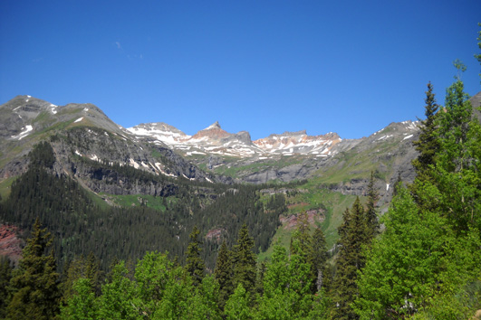
Still looking up at Ice Lake
Basin: Vermillion Peak, Golden Horn, and Pilot Knob are visible.
Now we're above tree line, looking
SW toward the Twin Sisters (L), Rolling Mtn., and Fuller Peak (R)
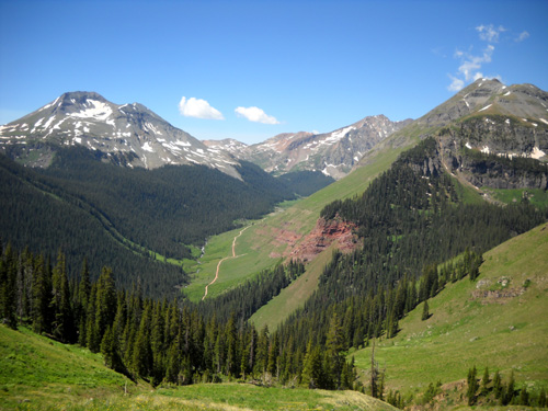
The San Juan Mountains are full of drainage areas, a utilitarian name
for creeks and waterfalls and lakes of all sizes! In early summer I
don't worry about Cody having enough water to drink on hikes. Snow is
still melting in the high country and the streams are at their finest
right now -- not flooding, not dry.
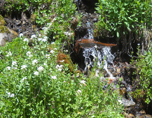
We passed several little waterfalls in the first couple miles of the
road, as well as some runoff in the ditches along the side of the road:
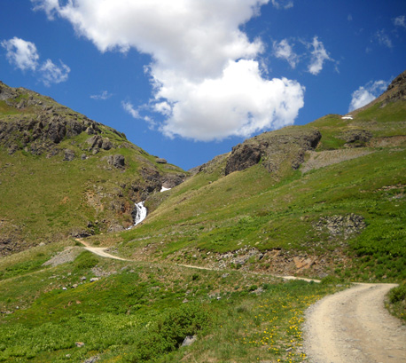
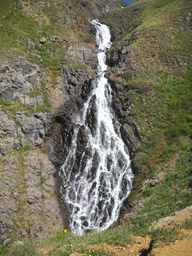
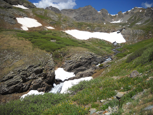
About half a mile above tree line is this much larger waterfall coming
from Clear Lake. This is the largest drop, perhaps thirty feet, that is visible close-up from
the road:
There are a several other large drops of Clear Creek that can be seen
farther downstream at two places along the Ice Lake Trail. I'll show a
couple of those waterfalls in another entry.
WHERE IS EVERYBODY TODAY?
Yes, this is a Thursday but it's the end of June, it's a gorgeous
day, and there is hardly any traffic on Clear Lake Road.
What's wrong
with this picture??
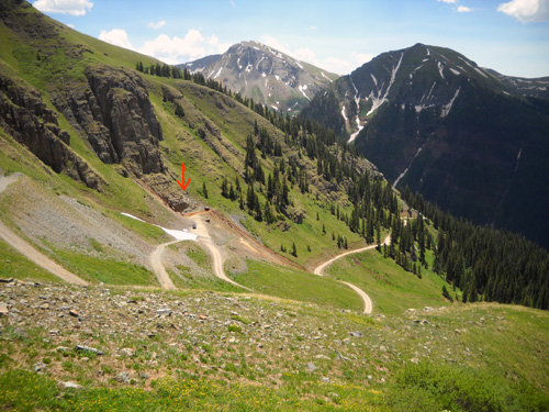
Looking back down some of the switchbacks above
tree line,
before and after the mine (marked with red arrow);
where are all the Jeeps?
Sometimes Clear Lake Road is as obnoxiously full of traffic as South
Mineral Creek Road, which is particularly a problem when it's as dry and
dusty as it has been this week.
Today there weren't that many vehicles on either road. That made us
pedestrians very happy, but we wondered why that was.
Well, here's one reason Clear Lake Road may have had so few vehicles on it today
(three motor bikes and only six or seven Jeeps and other vehicles):
A little over a mile before the basin that holds the lake are remnants
of an old mine. There is a tight switchback here and today it was still
covered in a snowdrift. It's the first time we've ever seen a drift
here.
Ahead of us we could see a Jeep trying (at first, in vain) to get up
the steep little hill on the loose rocks to the left of the snowdrift.
Only about three feet of the real road was free of snow; the rest
of the hillside is scree.
The Jeep driver eventually made it, and we talked with him when we got up to
the lake:
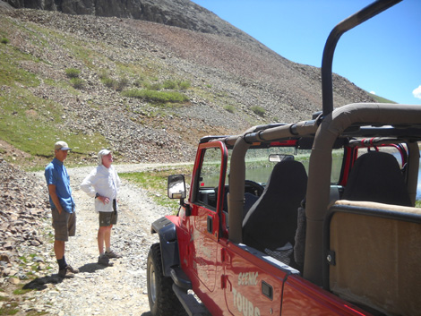
He's a tour operator in Silverton and was taking an elderly
client up to the lake to take photos. The visitor was determined to get
up there after paying his fee (which was also probably rather steep!) so
the driver pretty much bullied his way through the loose rocks and deep
snow in an effort not to disappoint his client.
Everyone else we could see from above and below that point turned around at the
mine and went back down. Perhaps other folks knew about the snow and
didn't even attempt going up the mountain yet. Even on a weekday in
early summer, there is
usually more traffic on this little road than there was today.

This guy gave up and turned around.
That made it all the more sweet for Jim and me. By the time we made
it up to the basin, we had it all to ourselves!
Well, us and
the marmots and the pikas. We always see a lot of marmots and pikas here.
For rodents, they're pretty darn cute.
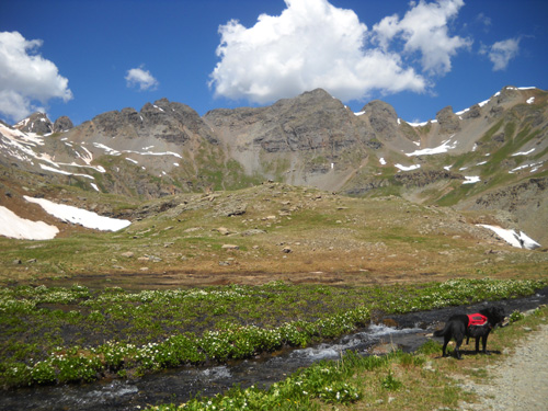
CLEAR LAKE BASIN: IN OUR OWN LITTLE WORLD
It's a little over a mile past the mine until you reach the basin and
Clear Lake. At this elevation there are views of the basin in front of
you but you can't see the lake until you're right above it.
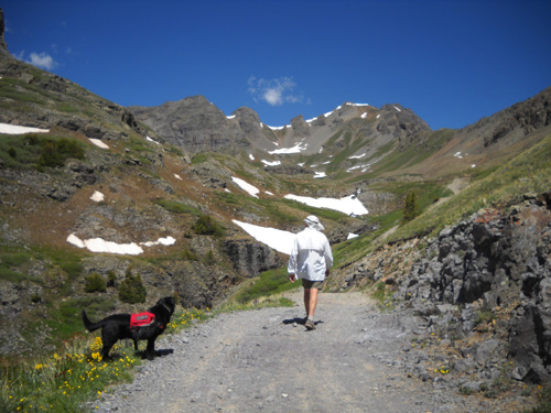
Don't let this little downhill
section fool you; you still have to do some climbing to the lake.
Clear Creek is down on the left;
it flows from the lake and down to South Mineral Creek.
The road becomes even more narrow and rocky after the switchback at
the mine. You could probably get up to the lake in a 2WD vehicle when
the road is dry but there would be a lot of bouncing around and
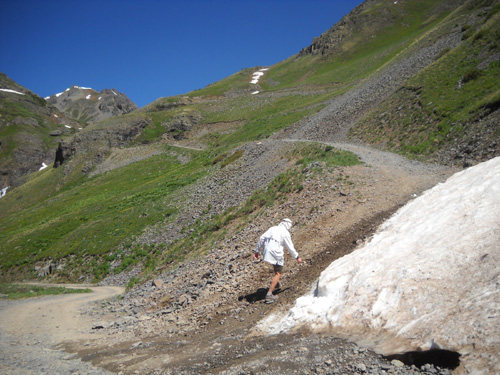
potential problems on hills with loose rocks:
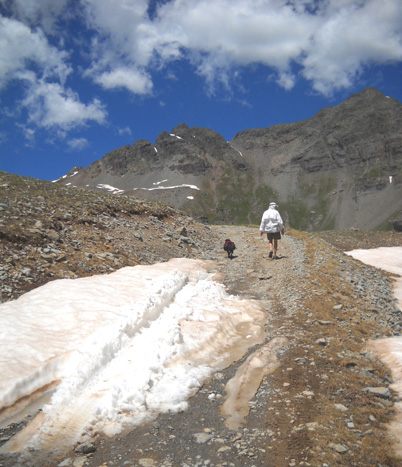
There is still some snow up here at 12,000 feet, to Cody's delight. I
especially like the "creek cornices" with water flowing underneath and
flowers (these are yellow alpine avens) popping up as soon as they
start getting some sunshine:
There are a couple of even smaller roads branching off from Clear Creek
Road between the mine and the lake. We've never taken the time to go up
either one -- and I'm wondering why because the views would be great!
The little track to the left in the next photo might take us high
enough to look over the ridge and give us views down
to the Lower Ice Lake Basin, which has trails leading to both
Grant-Swamp Pass (in the Hardrock race) and the Upper Ice Lake basins:
"Someday" we need to hike up the
little jeep track to the left and look down to the
Lower Ice Lake Basin. Today we
kept moving forward to the basin beyond Jim and Cody.
As we climbed higher we entered the tundra marshlands that are typical
of the San Juans: creek headwaters, pools of water, lots of marsh
marigolds and other alpine flowers that love wet feet and frigid
temperatures:
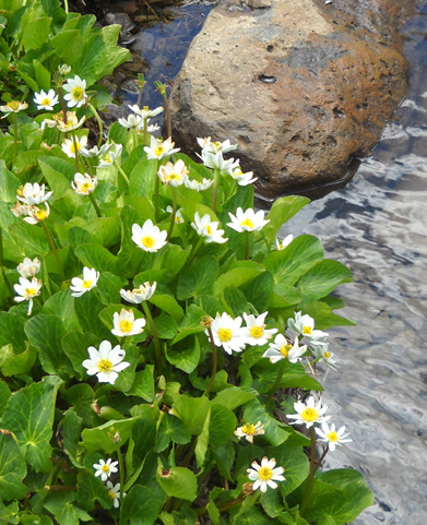
Marsh marigolds
Cody thinks snow is pretty
useless if he can't roll around in it.
He'd slide right off these hard, sloped snow banks.
Right past this snow bank is a great view of the lower
part of Clear Lake Basin and no, not Clear Lake, but a pretty pool formed by
creek water next to the road:
This is the view from the other side of the pool of
water. Note all the marsh marigolds:
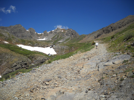
I think that view alone would be worth the trip up to
the basin, but we aren't even to the lake yet! That's up another
rise:
I like this picture because it
looks so doggone remote.
OK, enough teasing.
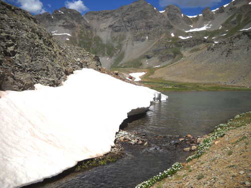
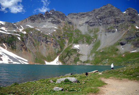
Here are some pictures of Clear Lake
from lake level. The color of the water changes with the different
angles from which I took the photos:
To see what the whole lake looks like (it's not real
big), check out the photos in my July, 2006
entry when we went up on one of the ridges.
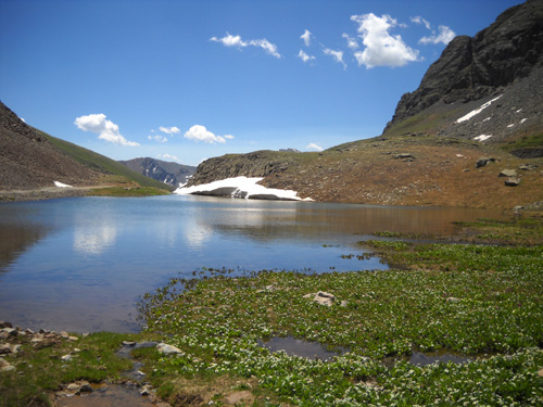
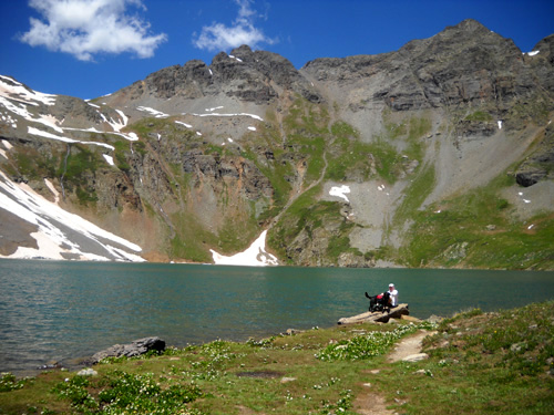
It was breezy but sunny and quite pleasant by the lake so we spent
a while absorbing the beauty of the place. It was
very calming, especially since no one else was there. The Jeep tour
guide and his guest left before we reached the lake itself.
Although there was still some snow above 10,000 feet in crevices,
cirques, and the creek, there was no ice on the lake like we've
sometimes seen before in June.
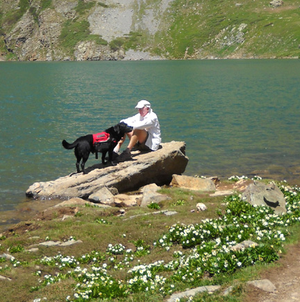
The lake water was ice cold, however. Cody was able to drink water in
Clear Lake, the beautiful creek that flows from it (below), and some
runoff along the road, but he wasn't keen on swimming around in the
frigid water!

The only place Cody couldn't drink water was at the mine and from
the stream directly below it:

Yuck. We don't know what chemicals are in there. Can't be good
for people, either.
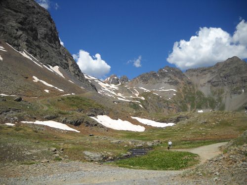
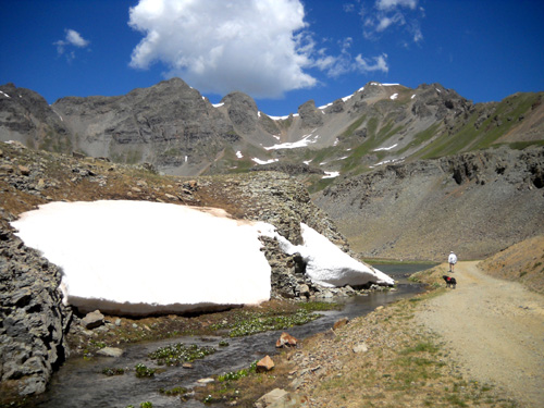
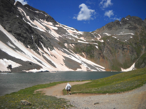
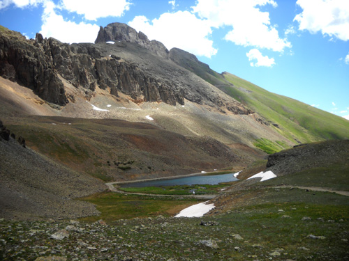
After about fifteen minutes Jim decided to head back down to the
campground, running as much as possible. I took this shot of him from
the little hillock above the lake. He's the white speck on the
road, already looking like he's far away. This perspective shows
the view northeast of the lake and lower pond by the road:
Cody and I stayed at the lake for a few more minutes to nose around and take more pictures,
respectively.
Since I have so many photos to share, I'll continue in the
next entry with shots I took on my hike back down the mountain and
include some of the flowers I saw. The scenery looks different going the
opposite direction!
Happy trails,
Sue
"Runtrails & Company" - Sue Norwood, Jim O'Neil,
and Cody the Ultra Lab
Previous
Next
© 2010 Sue Norwood and Jim O'Neil
