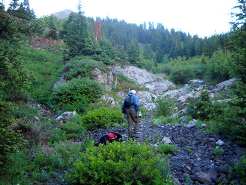
It's a toss-up as to whether Segment 24 or Segment 25 is my very
favorite of the twenty-eight sections of the Colorado Trail (CT). They
certainly rank as my Top Two. Segment 23, which now connects to Segment
24 at Stony Pass since the major re-route described above, comes in
third or fourth on my list (part of the Hardrock course follows the CT
in that section).
Each segment has its virtues:
Segment 25,
which I recently featured in the June 30 and July 2 entries,
- has less elevation gain and loss over the
eleven miles Jim and I usually run or hike it between Molas Pass and
Rolling Mountain Pass;
- the entire segment is 21 miles from Molas
to Bolam Pass but access to Bolam requires a 4WD vehicle so we went
there only in 2006 when I was doing the entire Colorado Trail.
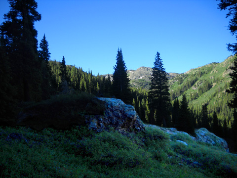
- Although it stays above 10,000 feet the entire way, the trail
undulates and has no steep grades.
- Much of it is smooth.
- There are always numerous flowers in the summer, there are several
creeks and waterfalls, and the views of the surrounding valleys and
mountains are excellent.
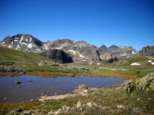
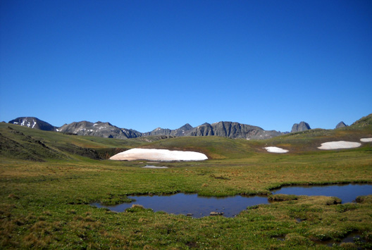
Scenic little pond on the Continental Divide in Seg
24, with the Grenadier Range for a backdrop
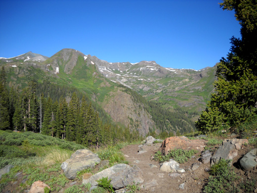
Segment 24, which is about 22 miles long,
-
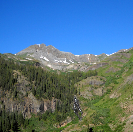
has numerous alpine flowers and ponds in the tundra, an old mine,
lots of cascades and waterfalls, a dramatic creek that disappears and reappears
among the rocks, a bridge across the Animas River, and the possibility
of a steam train ride to Durango or Silverton.
- It is more difficult to access than Seg. 25 . . .
- . . . but
the views along and from the Continental Divide are superlative. I liked the
original course when I first ran/hiked it in
2006. At that time it followed a dirt road for
several miles before climbing up on single track to the Continental Divide;
it was on the Divide for less than a mile. I like it much better since it was rerouted in
2007 to follow about seven miles of the Divide from Stony Pass to
Elk Creek. Awesome!
This beautiful alpine lake is one
of several that are visible from the re-routed trail.
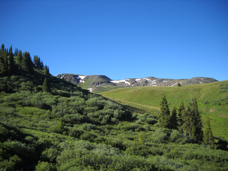
- As long as you're acclimated to the elevation, this part of the
trail is fairly easy to run or hike. It undulates gradually at or
above 12,000 feet and tops out at 12,690 feet before its dramatic
plunge into the Elk Creek Canyon/Gorge.
- The footing is more challenging along Elk Creek but as long as
you're going down the canyon you've got momentum on your side. For
most people it's tougher going up 3,800 feet to the Divide than going
down 3,800 feet to the river.
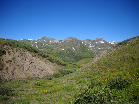
MY FAVORITE CT VIEW
The view from the Divide at the Elk Creek trail intersection gets my vote for
The Very Best View along the entire 486-mile Colorado Trail. I haven't
stitched together a
panoramic shot but here's enough to whet your imagination:
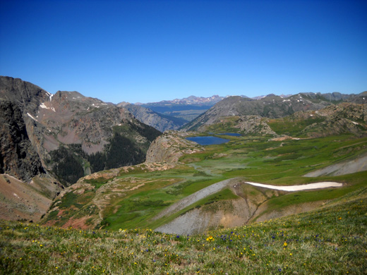
You've got the rugged quartzite (not granite) Grenadier Range on the left, beautiful alpine lakes
in a bright green basin on the
right, and other colorful mountains in every direction as far as the eye
can see.
I don't know how it can get much better than this! I guarantee you
it's more impressive in person than any photo can convey, especially a
little one like this.
If you
have any clue about how much I love to be in the mountains above tree
line with unobstructed views in every direction you can just
imagine how happy I was to spend several hours hiking along the
Continental Divide for more than ten miles today! I felt like I
was literally on top of the world. It was exhilarating, a real
. . .
. . . ROCKY MOUNTAIN HIGH
Every summer we've been back to the San Juan Mountains I've wanted to
recreate that feeling by running or hiking the relocated section
of Segment 24 along the Divide. Now that my knees are
compromised and I can neither run nor do steep, rocky descents,
it's not practical for me to go either direction on the Elk
Creek-Molas Pass section any more; it drops from 12,690
feet on the Divide to 8,920 feet at the Animas River through
sometimes-rough canyon and forest terrain, then ascends to
almost 11,000 feet at Molas
Pass.
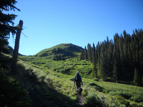
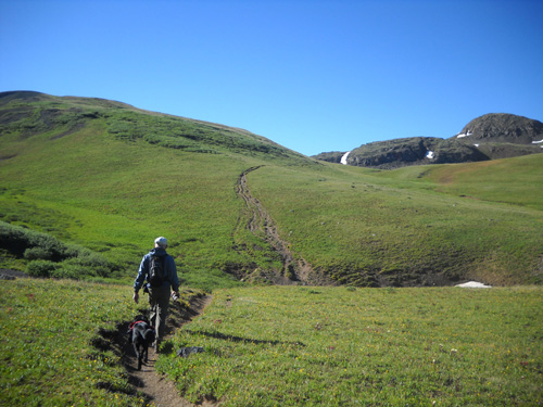
So how do I get up to the Divide?
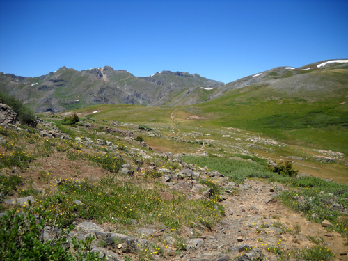
CT Segment 24, looking north along the
Divide; you can see the trail meandering in the distance.
Well, at the other end there's the Stony Pass trailhead.
In 2007 Jim and I still had a 4WD truck that could carry us up
steep, rocky FSR 737 from Howardsville to Stony Pass, location
of the new trailhead between Segments 23 and 24 (the CT was also
rerouted along the Divide in the southwestern part of Seg 23).
Crews were still working on the trail that summer and hadn't finished
putting up all the signage. I wrote in the '07
journal how we managed to
follow the new trail to Elk Creek Canyon, where we turned
around, but lost it partway back and had
to do some orienteering over hill and dale.
In 2008 we didn't go out West for the summer because of high gas
prices (we still regret that decision -- just should'a
gone).
In 2009 we replaced our 4WD F-250 truck with a 2WD Ram 2500. No
way will we take it up to Stony Pass! (There's good reason for
that name.)
That meant finding another way for me to reach the CT along the
Continental Divide.
The access trail we found is scenic, too.
We researched our trail maps and found a viable solution --
a 2+-mile trail from the end of Cunningham Gulch that intersects
with the Seg 24 reroute a couple miles south of Stony Pass. It
looked steep on the contour maps but seemed to be the best
option.
Unfortunately, we put that run/hike off until our second trip to
Silverton at the end of last July and had it scheduled for later in
the week that I had my serious bike crash. My injuries pretty
much ended any thoughts of such a challenging hike as this in
the time we had left in the Silverton area.
So . . . it's been three long years since I've had my
Segment 24 fix. I was determined to do it this trip. Today was
the day, and it was a mah-velous one!!!
THE PLAN
We could not have picked a more perfect weather day for this
run/hike. Even at the end of the afternoon when I picked up Jim
at Molas Pass there were only a few fluffy white clouds on the
horizon in any direction. We had clear blue skies, a slight
breeze, and moderate temperatures -- remember, much of
the time we were above 12,000 feet and almost all of the time
above 10,000 feet.
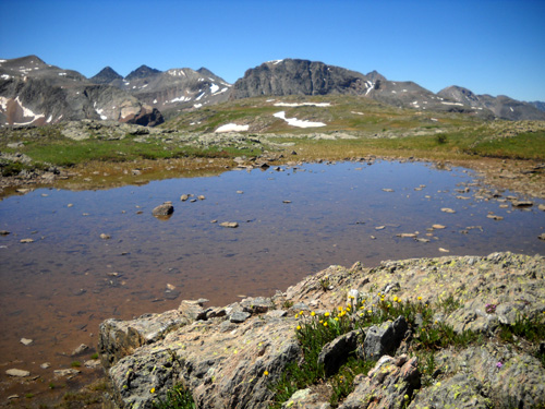
Alpine ponds reflecting the azure blue sky
on the Divide
Our basic plan was to hike up the trail from Cunningham Gulch,
intersect with the CT, and follow it to the head of Elk Creek
Canyon. At that
intersection Cody and I would turn around and retrace our steps
to the truck, for a total distance of about 14 miles out-and-back.
Jim planned to continue forward on Seg 24 -- down Elk
Creek to the Animas River and back up to Molas Pass, for a total
of about 21 miles point-to-point. When I got done, I'd drive the truck
12-13 miles to Molas Pass and pick Jim up.
There was one hitch that altered our plan just a bit but Jim and
I got in the miles and routes we'd planned. Cody's the one who
came up a bit short! We also deliberately did a little re-route
along the Divide and reached our highest elevation of
the day on that slope (12,745 feet).
I'll explain both changes to the plan later.
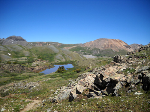
Pretty pond near our deliberate re-route
PHOTO PHREAK
This is a fabulously scenic route on a beautiful day like today. I took
a gazillion photos
in the 14+ miles I hiked and at Molas Pass while I waited for
Jim. When you see some of these views, I think you'll understand
why I went a little nuts taking pictures!
I also talked Jim into
carrying our old camera so he could take some
pictures along the fourteen miles of trail I didn't hike today. I can't show all
of our photos here but I'm going
to include enough to divide them into four journal pages to make
loading faster.
- This rest of this page will describe the new trail we found up to
the Continental Divide from Cunningham Gulch.
- The second part will cover the
five miles of the CT that we traveled on the Divide from that
trailhead to the top of Elk Creek Canyon.
- Part 3 will
show photos of those seven miles in the other direction (yes, it
looks different!).
- The last part will be about Jim's additional 14-mile run/hike down the
canyon and up to Molas Pass, mostly featuring his pictures.
Enjoy the views!
OUR NEW ROUTE TO THE DIVIDE
We've got four detailed maps that include Cunningham Gulch, the
old CT route, and the Continental Divide Trail (CDT) --
the official guides to both trails and a Colorado DeLorme atlas,
all
from the mid-2000s, and a Drake Mountain Map of the San Juans
that was revised in 2000.
The best I can do as far as a name or number for the trail we
used to get up to the Divide is possibly Trail #502. We never
saw that on any signposts, however, either at the beginning or
end of the trail.
Until I find out what its real name is, I'm going to call it the
Cunningham Gulch Access Trail.
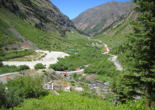
We drove about three miles back Cunningham Gulch Road (FSR 589,
marked #1 in
picture above) to the Cunningham Creek crossing (#2) and waterfall at the
far end of the lower gulch.
There are several places to park (#3) near an old slag heap and
other remains of an old
mine (#4). To this point the road is fine for 2WD vehicles.
After the mine the road becomes more narrow, steep, and rocky
(#5). We could probably get our truck up another mile to the
next parking area in a higher part of the gulch below Spencer Basin but we'd still have to
walk the same distance on the road to reach the trailhead we
wanted.
The next photo shows the second parking area (red arrow)
and the road as it continues switch-backing up toward the basin:
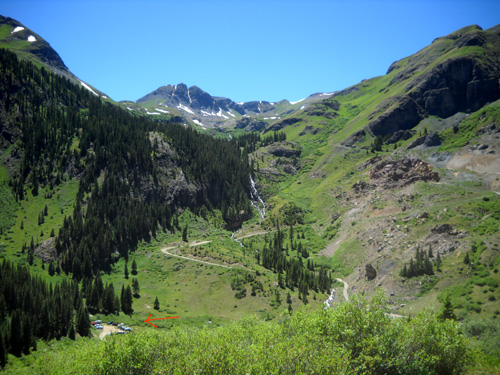
Another trailhead (at arrow) and continuation
of FSR 589 toward Spencer Basin
After parking near the mine we walked up the rocky road about
half a mile until we
found the unmarked trailhead through some willow bushes and
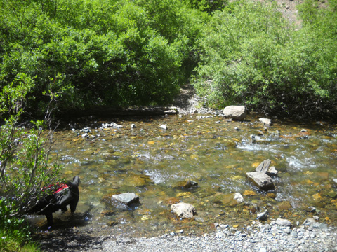
across Cunningham Creek:
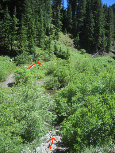
We spotted the trail on the other side before we noticed the
inconspicuous path right next to us that goes down to the creek through the dense
shrubbery.
This time of year the water is shallow and not a problem to
cross, although you'll probably get your feet wet:
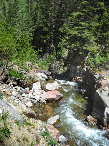
It's more flat and spread out here than it is just downstream
where it descends rapidly through rock chutes all the way
down to the mine:
Within about 200 feet we reached the boundary of the huge
(almost 500,000 acres) Weminuche Wilderness and
signed the register for backcountry hiking. The wilderness is
named for a band of Ute Indians who used to inhabit the area.
Dogs, horses, and
pack animals are permitted in the wilderness but not bicycles.
Ditto for the trail up on the Continental Divide where we hiked.
Cyclists must
detour around all or most of CT Segment 24.
Because we were heading east into the sun early this morning my
photos going up this trail are perfectly lousy except when I
aimed the camera south toward Spencer Basin or west behind me
(north was the mountainside we were on). For that
reason I'll show only a couple photos of the terrain through the
woods on the way up to the high meadows:
In Part 3 of this series I'll show you better pictures of the trail
when I came back down this afternoon. By then the sun was
directly overhead and my photos came out much better. (Despite
all the collective wisdom to take photos in the early morning or late
afternoon light so they look better, I haven't figured out how
to do that with this camera. I'm too lazy to do it manually.)
The views toward Spencer Basin were great going up and coming
down this trail. As I got higher and higher I could see more of
the basin:
Spencer Basin and falls along Mountaineer
Creek
The more I saw of it, the more determined I am to go up there on
another day! I met a group of young folks doing
a loop hike today, incorporating this trail, the CT/CDT, and
one or more trails to Highland Mary Lakes and Spencer Basin.
I've added that circuit to my list of future hikes . . .
My photos started coming out better once we got near and above
tree line; there wasn't so much contrast between sun and
shade:
Most of the photos in this entry will be facing in the direction
we're going or off to the sides but this one looks back at the basin once we're near
the timberline:
Through the woods this trail is relatively steep and has some
loose rocks and grit. With bad knees and old trail shoes with
minimal grip on the soles, that was more of a problem to me going
down than going up.
We climbed from about 10,400 feet to 12,400
feet in just over two miles to reach the CT. The
pitch was steeper in the first mile through the forest than the
second mile in the alpine zone. Since we're not totally
acclimated to these altitudes yet, and this was a challenging
trail, it took us over an hour to make the climb to the
intersection on the Divide. Alone, Jim would have climbed it
faster than I did.
Looking south from the access trail before
reaching the Divide
Once above tree line we started making better time because the
trail was less steep and rocky. We crossed a stream not far below
its headwaters and continued our climb up the braided
trails on the other side:
From that angle you can't see much of the snow bank over the
creek to the right but that was Cody's first of several
opportunities to play in the snow today.
This is the scenic view west down that creek drainage toward Spencer
Basin and Cunningham Gulch:
Although there were some pretty flowers along the trail through
the woods, we started seeing more as we climbed higher and
higher. By the time we reached the tundra it was common to see
the entire ground carpeted with sturdy little alpine flowers
like mountain avens, bluebells, sunflowers, and Indian paintbrush. Up this high they
don't grow much higher than five or six inches tall but they sure are colorful.
We were quite happy when we saw the CT/CDT sign on the Divide:
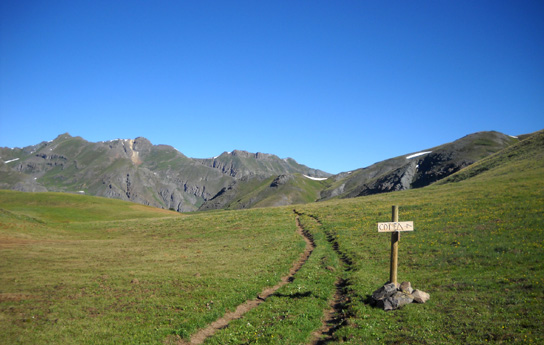
Made it!
We were happy to discover that the access trail really
did take us where we wanted it to go; you can't always
trust older maps.
Continued on
Page 2: cruising
along the Continental Divide to My Most Favorite CT View
Happy trails,
Sue
"Runtrails & Company" - Sue Norwood, Jim O'Neil,
and Cody the Ultra Lab
Previous
Next
© 2010 Sue Norwood and Jim O'Neil
