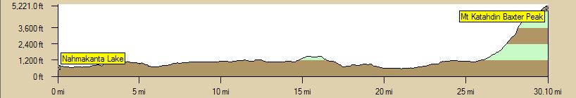
The Final 50K
Oh, my. It looks like someone hic-cupped when they were drawing this profile!
(Information on this page is excerpted from The Official Appalachian Trail Guide to Maine, 2004 edition, pages 46-7)
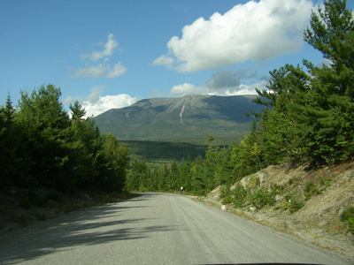
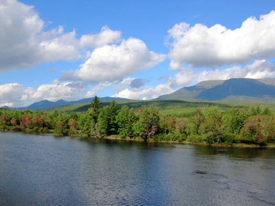
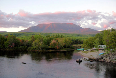
KATAHDIN. To the Abenaki Indians, it was known as "Kette-Adene," the "greatest mountain." The northern terminus of the Appalachian Trail, Mt. Katahdin is one of the highlights of the Trail. The mountain rises as an isolated, massive, gray granite monolith in an area of Maine that is heavily forested and full of sparkling lakes. It is the focal point of Baxter State Park, a popular destination for hikers and other nature-lovers.
The mountain looks different from each direction. So far, we have seen it primarily from the south, where it forms the long, undulating profile seen in these photos we took from Abol Bridge and the road leading to it. The summit is 5.267 feet, not the highest along the AT, but the highest peak in Maine.
Katahdin has been described as an enormous flat fishhook. The projecting point is the rounded dome of Pamola Peak (elev. 4,902 feet). To the Native Americans who lied under the mountain's influence, Pamola was the diety of Katahdin. In awe of Pamola's wrath, they never dared venture too near Katahdin. Until 1804, no non-Native Americans had explored the mountain. Charles Turner was the first Euro-American to summit Katahdin.
In the bend of the fishhook are three enormous basins with sheer gray or pink granite walls that rise abruptly 2.000 feet above the basin floors. Encircling the Great Basin for three-quarters of its rim is the famous "Knife Edge," a narrow wall of vertically-fractured granite. In some places, it is only a few feet wide, with precipitous slopes dropping 1,500 feet on each side.
Some AT thru-hikers descend via the Knife Edge. We won't be going there! The official AT route is bad enough, and it will return us to our truck. Other easier routes down would also require hitch-hiking back to our vehicle.
The vegetation on Katahdin was determined by the glaciers that carved it between ten to fifteen thousand years ago. Treeline is only 3,000 feet. Above that, the flora is similar to that found on the Canadian tundra, in Greenland, and in northern Greenland. When we go up, we will be above treeline for 2,267 feet. This isn't somewhere you'd want to be on a bad-weather day! (And the rangers wouldn't let you summit if they thought the weather would be bad.)
The climb to the summit via the Appalachian Trail is significant - nearly 4,200 feet in only five miles. (And we have to come back down, giving us 8,400 feet up and down in 10.4 miles - ouch!). The most difficult part of the climb is "The Gateway," about a mile long and just above treeline.
I'll let you know on Day 148 how it went!