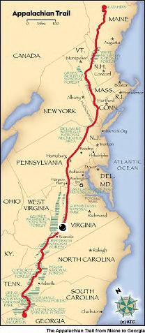
|
APPALACHIAN TRAIL ADVENTURE RUN | ||
|
Runtrails' 2005
AT Journal
DAY 47: WEDNESDAY, JUNE 15
I had the pleasure of running the first half of this section with Graham
Zollman again, the third time he's accompanied me since last Friday. It was a
new section of the Trail for him, although he's been on some of the intersecting
trails during Horton's Hellgate 100K and Promise Land 50K ultra races. He had
fun figuring out where he'd been as we passed various trails such as the
Glenwood Horse Trail. The Trail was varied and interesting today, with very runnable trail most of
the first half. After Graham turned around to run back to his truck around
twelve miles, the terrain turned more rocky but I was still able to run some of
the downhills. Graham loved the section he ran, and intends to return soon with Dru on a
training run. I'd love to show it to Jim, too. There was a lot of climbing today. The low point was Jennings Creek at 951
feet; the highest was Apple Orchard Mountain at 4,225 feet. As usual, there were
numerous ups and downs the whole way, including an 1,100-foot climb to the top of
Fork Mountain, 2,223 feet up to Floyd Mountain, and another 1,100 feet to the
FAA tower on top of Apple Orchard Mountain. Looking at the profile, I'm
estimating a total elevation gain of 6,500 feet today, with a loss of about
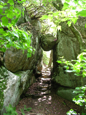
4,500 feet. The most interesting rock formation today was "The Guillotine," pictured
above. It's located a bit north of the peak of Apple Orchard Mountain. I loved
it and want to show it to Jim. He said it reminded him of Aron Ralston's story
(the hiker/ultra runner who cut off his arm when a boulder rolled on it in the
Utah canyon lands), but this one doesn't look like it's going anywhere any time
soon. Still, I surveyed it pretty closely before walking under it! It took me a little over nine hours to complete this section, but I was
handicapped with a very sore right upper thigh that made running and even
walking downhill very painful the last nineteen miles. You see, I fell again.
Hard, on rocks. My thigh took the brunt of the force, but I also re-opened older
wounds on my right arm and knee. <sigh> That's #10. I'm both glad and embarrassed that Graham was there: glad because I
was hurting and he was able to help me up, embarrassed that he saw me at my
worst. I was covered in grit but waited to wash off until we got to Jennings
Creek about half a mile away. I didn't bleed enough to require any bandages
until I got back to the camper and took a shower. I'm surprised my thigh didn't swell up immediately and turn black and blue. I
knew I didn't break a bone, but gosh, it hurt all day. I must've really mashed
one or more of the quadriceps because the downhills were more painful than the
uphills. I called Jim to warn him I might need to bail out early, but the pain
never got worse so I kept on going. I recited the quote at the top of this page to Graham, who had never heard it before. It's one
of the first quotes I heard when I started running ultras. We're a strange
breed, indeed. PERFECT WEATHER DAY Graham and I couldn't have asked for better weather today. Although it was
supposed to be in the low 90s in the valleys below us, it was probably in the
60s and 70s up where we were. The sky was bright blue, the clouds were puffy
white, and there was a stiff breeze everywhere I ran except in the rhododendron
thickets. Most of the run was shaded, which was good for keeping me cool. Most of the run was shaded, which was not so good regarding views. Leaves
obscured all the beautiful valley views I knew lay before me on either side of
the ridges I ran. The only time I could see them was on the two balds on top of
Apple Orchard Mountain. This is another section that would afford great views
when the leaves are down. But then, you wouldn't see the beautiful mountain laurels, rhododendrons, and
flame azaleas that bloom in May and June! There's an upside and a downside to
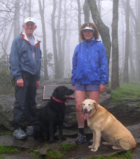
just about anything, isn't there? I was glad the weather was clear early this morning when Jim and I drove the
truck and camper up the Blue Ridge Parkway from our home to Bearwallow Gap. We
got to enjoy marvelous valley views for about fifteen miles; so did Graham (it
was very foggy two days ago when Graham, Dru, and I drove up there to leave a vehicle). Jim was impressed. I'm glad he's enjoying the scenery because he plans to do
some runs on the Parkway while I'm on the AT in this area. It'll make his runs
more interesting when he can see vistas like this. In fact, he'll probably see
more from the Parkway overlooks than I will in the "green tunnel" of the AT. MR. FUSION, DOGBREATH, AND GRASSHOPPER It was a good day for seeing other thru-hikers - and for just missing one I
am trying to catch. At the first of four shelters (Cove Mountain), we met "Nokia," a young man on
his way north. Graham was able to answer questions he had about getting to his
mail drop in one of the towns below us. We saw more "trail magic" here:
someone left a couple large bags of whole wheat pasta for other hikers, with
instructions on how long to boil it. Then we played leap-frog with "Mr. Fusion," a 30-something fella from
Charlottesville, who is a marathoner. He's one of many thru-hikers I've
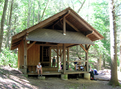
seen wearing running shoes. The next shelter, about ten miles in at Bryant Ridge, was full of teen-age
hikers, their adult companions, and a couple thru-hikers. I was fascinated with
this appealing building that was obviously designed by an architect (as opposed
to the usual three-sided rectangular shelters). The photo above doesn't do it
justice. It's an open L-shaped loft design with a ladder, peaked roof, and
porches on two sides. This is the most beautiful shelter I've seen on the Trail so far. It was
built in 1992 in memory of Nelson Garnett, Jr. from a plan selected from
submissions by Nelson's fellow Catholic University architecture students. I skipped the next shelter (Cornelius Creek) because I couldn't see it from
the Trail. It's in a jungle-like area of thick rhododendrons, laurels, hemlocks,
and ferns called "The Mash." This was one of many areas today that were full of
wildflowers, too. And the butterflies - I've never seen so many butterflies in
one day! I wish I could identify them; there were many different colors. I stopped to eat a food bar on a large rock and "Grasshopper" passed by. I'd
met her near Pearisburg, and she remembered I was the runner. I passed her again
near Apple Orchard Falls Trail when she took a break, and we talked about
the pros and cons of going down to the falls. I've seen them before (they are on
Horton's Promise Land 50K course) and didn't want to go out of my way over a
mile down a fairly steep hill to see them today. Grasshopper had already pretty
much decided her sore feet didn't need the extra mileage, either. (She's also
middle-aged.) The fourth shelter, Thunder Hill, is set amongst Catawba rhododendrons, which
were still in bloom at that higher elevation. There I met a young couple
thru-hiking with a dog (we compared notes on the pros and cons of that) and -
would you believe it? - another thru-hiker called "Dogbreath!" I love that name.
Jim calls me that sometimes after I let Cody or Tater kiss me. When I was reading the trail register here, I noticed "Pizza the Hut" had
signed just before me. Dogbreath said he had "just left." Aha! Let's try to
catch him! Well, even though it was downhill all the way to Petites Gap four
miles below, the trail was rockier and I was more tired and sore than earlier
and I wasn't able to catch Pizza. I
called Jim to tell him I was getting close; he'd just arrived at Petites Gap
with both dogs and was on his way in to see me. I told Jim that Pizza (Josh) was just ahead of me, so he was able to tell him
I was getting closer. Pizza intended to go on another nine miles past Petites
Gap to catch up with another thru-hiker named "Scared," so it may be another day
or two before I catch up to him. (We met Pizza the Hut near Erwin, TN when he
was working on a new section of trail with Bob Peoples, the proprietor of the
very popular Kincorra Hostel. Pizza is also a marathoner - that's two today!) FLORA AND FAUNA This area is rich in beautiful trees, shrubs, and wildflowers. Graham kept
exclaiming how green the forest floor was in certain sections, like carpeting.
From one end of the section to the other, I kept going through different
eco-zones as I went up and down: lush green deciduous forests with all
kinds of under story plants, dry pine groves with pine-needle footing on the
Trail, dense thickets of rhododendrons and laurels, and two grassy balds (the
only places where I could see the valleys below). I saw some new colors of spidorwort today (blue and pink, along with the
white, fuscia, and purple I've seen before), some tall white flowers at eye
level (Cow Parsnip), and pink flowers on a shrub that almost looked like roses. The Natural Bridge AT Club has been busy trimming back foliage in this
section. I was grateful for the places they'd cleared, since I've seen several
huge black snakes the last few days. Graham saw one this morning that I missed.
Later, I saw a smaller black snake with yellow stripes down either side. I sure do like to see where I'm putting my feet down,
especially now that the snakes are out, so thanks to the clubs who keep the
rampant summer growth in check. ROAD MAGIC Instead of playing trail angel today, Jim got to play road angel. On
the way to our new campground in Buena Vista on mountainous VA 501 we came upon
a two-vehicle accident around a blind curve in either direction. Three other
vehicles had stopped to help, but no emergency vehicles were on the scene yet. Since Jim is trained with EMS and the fire department he stopped to see if
anyone was hurt (no). He carries flares in the truck, so he put several of those
out in either direction to slow the speeding semi trucks and passenger vehicles.
Before we left a fire truck arrived. I'm glad Jim was able to be of assistance. Jim found a nice city park campground in Buena Vista (Glen Maury Park). He
had no idea there is a large fiddling contest in the park this weekend, but it
turned out to be to our advantage. Not only did we get a nice site half a mile
away in a quiet section, we got it for only $13 a night with full hook-ups!
That's cheap. It's what they're charging the dozens of fiddlers who are camping
in the lower section next to the Maury River. And we get to enjoy our camper neighbors on the hill who "jam" when they
aren't enjoying the festivities below! I'm pretty sore and tired tonight, and re-evaluating my plan for a 31+ mile
run tomorrow. I was very clumsy all day on the Trail because of lack of sleep
last night. I was kicking rocks all day, even when I was walking. I'm probably
going to shorten my run tomorrow, or even bag it if my leg is very painful in
the morning. |