We've wanted to visit Moab for several years but just never got
around to it until this spring.
Although our original intention was to spend just three or four days
here, we found so many things we wanted to do -- and, honestly,
it was snowing at our next stop! -- that we ended up
staying a full two weeks in the area and modifying or canceling several
other planned destinations.
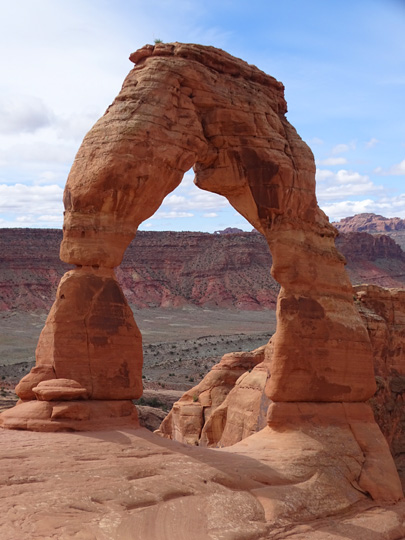
Iconic Delicate Arch at Arches NP
is featured on Utah's license plates.
It's getting increasingly more difficult to make spontaneous
decisions like this because so many more people are occupying
campgrounds and RV parks now.
However, we decided to shorten our stay at one of the pricey RV parks
in this hip town when we discovered a very nice, very inexpensive BLM
campground up on the plateau above (literally) Moab and snagged one of
the best sites we've had in a while, thanks to a tip from the campground
host. I'll talk about that in another entry re: camping at
Horsethief Campground, shown below:
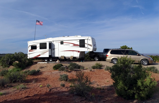
Our perch with a great view on the high mesa above
Moab
The decision to stay in this area longer
meant we had to make changes to several reservations we had already made
for this spring and summer in Utah and Colorado. It took some time and
effort but we were able to successfully tweak some dates and are very
happy with our new plans.
This map section from the
DiscoverMoab.com homepage shows the
proximity of major natural and manmade attractions in this area:

The private RV park where we stayed the first three days is at the southern edge of Moab; I
marked the approximate location of the BLM campground where we stayed
the remaining time near Canyonlands NP with
a green dot.
Both campgrounds were good locations for visiting Arches and
Canyonlands National Parks, two of Utah's five national parks we're
visiting this year. Even being in the area for two weeks didn't give us
enough time to do all the hiking and other activities we could have done
so we'll just have to come back again in the future.
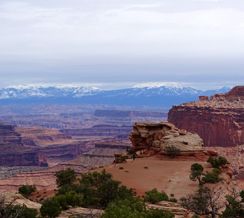
The Grand Canyon? Nope --
it's Canyonlands National Park!
This entry will focus on today's scenic drive from Zion National
Park to Moab, information about the Spanish Trail RV Park, where we
stayed just two nights, and some scenes from Moab during the two weeks
we were in the area.
Subsequent entries will be as much by location as by the actual dates
the hikes, bike rides, scenic drives, etc. occurred. I need dates to
keep the entries and photos organized on the website.
FROM ZION TO MOAB
We really didn't want to leave Zion National Park yet
but we were excited about going to a destination that was new to us.
It was a beautiful day again with blue sky and white
clouds highlighting the beautiful desert scenery along the way --
gorgeous rock colors, interesting formations, and lots of small canyons. This
is "Canyon Country," after all.


Who knew a freeway could be so beautiful! (Actually we already
did, because we've driven this part of I-70 previously.)
It was chillier along this route than it was in Springdale, with
temps in the 40s F. most of the day because we were several thousand
feet higher. We topped 7,000 feet at least three times along I-70 and saw
some snow at the higher elevations along I-15 and I-70:

Bright sunshine heading west on
UT 9 west of Zion early in the morning

White clouds over snowy mountains
heading north on I-15

Darker clouds and more snow in
the Pahvant Range near the beginning of I-70

Then a roller-coaster ride with
pretty blue skies the rest of the way!
Here's a UT map section of our route:

We started at Springdale/Zion NP, the red dot in the lower left corner. We headed
west on UT 9, north on I-15, east on I-70, and south on US 191 to Moab =
red dot in upper right. Total distance was 355 miles.
Note that between MM 56 to 161 on I-70, a distance of 105 miles,
there are no services.
This mountainous, curving route was relatively challenging for Jim,
who was hauling our 36-foot 5th-wheel coach, but we knew it was the best
route for us to take with the RV.
I had it easier following him in the Odyssey minivan and was able to
take several dozen pictures along the way, most while driving (I know, I
know) and a few at overlooks where we stopped to look at the views and
take potty breaks. It took us about seven hours to reach our destination
three miles south of Moab.

View from
the Salt Wash overlook, part of the ancient San Rafael Swell

Gorgeous colors!

Awesome clouds all afternoon

Amazing stripes, as seen from
another overlook

Looks like a locomotive . . .

That one looks like a sinking
ship near the top of a very long downhill section going east on I-70.

Another part of that long
downhill as we descended toward Green River

The descent on US 191 near the
entrance to Arches NP and the north end of Moab
Although this is a very scenic route the whole way, a more leisurely
and even more scenic alternate to get from Zion or Cedar Breaks to Moab
-- if you're not driving or hauling a large RV -- would be to follow
UT 9 out the east side of Zion NP, go north on US 89 to UT 12, then east on UT 12
and 24 to I-70. If you're looking at this entry on a large enough screen, you
can see those highways on the map above.
We've been on most of that route in our car and loved the scenery
through Grand Staircase-Escalante National Monument and part of Capitol
Reef National Park. It's doable with a large RV but even hillier and
slower than the route we took today. In addition, if you're starting
from the west side of Zion you'd have to deal with large-vehicle-in-the-tunnel
issues going out the east side of the park.
SPANISH TRAIL RV PARK
We made our reservation at this privately owned RV park in early
January after doing an internet search. We've seen several other RV
parks in and near Moab since we arrived and this one does look the best kept.
It should. It's more expensive than most places we've ever stayed
because of location, location, location. Although it's not what I'd call
a resort town, it's definitely a popular destination. We paid
$222.67 for four nights for a "deluxe" 60-foot site ($55.67/night) with
room for both of our vehicles + RV. At least they don't charge extra $$
for a third vehicle like more and more places are doing.

Sites near the entrance

Our pull-thru site in the back
The cost hasn't deterred folks, apparently. Most of the 80+ sites were full while
we were here from Sunday afternoon to Tuesday afternoon. (You'll see
later why we didn't stay four nights.)
The RV park is nice. There is
more room between sites than at many private RV parks. Sites are gravel with a concrete
patio, picnic table, and some grass. The roads are also gravel.
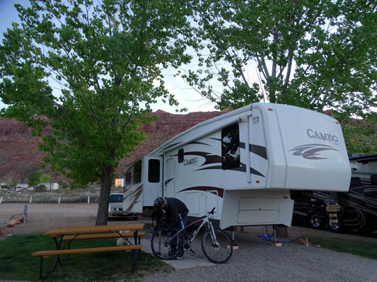
Jim works on his bike.
Spanish Trail backs up to a cliff on the west so we've been protected from
the wind in this location. I like that we are all the way in the back where we
can't hear the road noise.
We can take the dogs to potty along the back fence next to a field
behind our site and walk them in the campground loops to the more
distant dog walk area if they don't have to "go" right away.
The only downside for us at this RV park (besides the cost) is not having a
really good place for Jim to ride his bike with Casey because the gravel is hard
on her paws when she runs. The paved bike path that runs several miles north
of town along Hwy. 191 doesn't extend down here. There was too much traffic to take
her across the busy highway to this residential area that backs up to
the recreation area:

This area is
surrounded by mountains in every direction -- the Book Cliffs north of
Arches, the Henry Mountains to the west, the Abajo Mountains south of
Canyonlands, and the La Sal Range just to the southeast of Moab.
There are good views to the snow-covered La Sals from the front of the
campground:

One evening when Jim was out riding with Casey on the bike he called me to
come look at snow falling in the La Sal Mountains while the sun was still
shining on them. The lighting was interesting:

We were also able to see snow-covered mountains in the
Henry Range from Horsethief Campground on the mesa when we moved
the Cameo up there. More about that later.
OUR ACTIVITIES IN MOAB
Moab, which sits along the Colorado River and has a year-round population of
about 5,500 residents, has seen a series of incarnations since the 1800s. Its
economy was originally based on agriculture, then mining, oil, and gas deposits,
then Western movie production, and more recently, tourism.
Because of its stunning natural scenery, public parks and recreation areas, and extensive
slick rock, the area is very popular for a variety of activities including sight-seeing,
photography, RVing, backpacking, hiking, running, canyoneering, mountain biking,
road cycling, off-roading (Jeeps, ATVs, etc.), motorcycling, rafting, kayaking,
canoeing, fishing, rock climbing, and BASE jumping.

Jim enjoys the view at the end of the Grand
View Point Trail in Canyonlands NP,
near the confluence of the Colorado
and Green Rivers.
The area around Moab is an outdoor recreation mecca for folks like us,
especially in the spring when the high desert temperatures are moderate. Close to Moab
are Arches and Canyonlands National Parks, thousands of acres of national forest and
BLM lands, Dead Horse Point State Park, and the Sand Flats Recreation Area.
Most of our activities during our stay were centered around the two national parks,
the hiking and cycling trails adjacent to Horsethief Campground (since we couldn't walk the
dogs in the national parks), and several sight-seeing trips along the Colorado River.

Scenic trail where I could walk the dogs on BLM
land adjacent to our campground at Horsethief
We didn't visit the state park this time or pay to get into the recreation area with the
extensive slick rock but we'd like to see those places on our next trip to this area.
I took this picture of a Jeep having some off-road fun from just outside the
entrance to Sand Flats:

Moab itself is a quaint little town with a variety of shops and outfitters
stretched out for several miles north to south along the main street.
Our activities in town were mostly limited to going to the visitor center,
grocery shopping at the well-stocked City Market,

Jim parked here to shop after a 30-mile
bike ride!
I guess he really did feel like a
Senior Citizen that day.
hunting for a new bike seat at four different bike shops (couldn't find
the specific Serfas seat I wanted like was on my stolen bike),

Whatever works to draw more
mountain bikers . . .
riding on the paved bike
path along Hwy. 191 north of town, getting gas and diesel fuel,
taking the dogs to the large fenced BarkPark several times to socialize,


That guy had treats for everybody. I marked
Cody with a blue dot and Casey with red.
and getting treatment for Cody at the vet's office across from the dog park one day
when he was lethargic from dehydration. Fortunately, it wasn't something
worse. We've been living in very arid desert country for about a year
now and
we need to encourage him to drink more water.
We didn't go to any of the museums, specialty stores, or restaurants in town on this
visit. We probably would have done more things in town if we'd stayed at Spanish
Trails longer. Staying up on the mesa at Horsethief Campground was very convenient for
Canyonlands NP but farther to go to Arches NP or into town to run errands.
Here are a couple other scenes in Moab I shot in passing:

Above and below: This rock and
mineral shop features old mining equipment outside.

The remaining entries in this series will feature our hikes, bike rides, and
scenes as we were driving around the Moab area.
Next entries: introduction to Arches National Park and most of its trails and arches
Happy trails,
Sue
"Runtrails & Company" - Sue Norwood, Jim O'Neil,
Cody the ultra Lab, and Casey-pup
Previous
Next
© 2016 Sue Norwood and Jim O'Neil
