Another thing we read about while planning our trip to the Maritime
provinces is what actually motivated us to spend a week on PEI --
the Confederation Trail hiking and biking path that traverses 174 miles
of the island, part of the Trans-Canada Trail.
I offered to crew Jim if he wanted to ride it in sections but he
declined. We rode just part of it one day and found another scenic trail
along the northern coast of the island in PEI National Park.

View of the Gulf of St. Lawrence
from the Gulf Shore bike path in PEI National Park
We researched the camping, cycling, and hiking opportunities on the
island well before we picked up the colorful, comprehensive guide of
other things to do and see at the visitor center when we first arrived.
Unfortunately, we didn't adequately research the options for getting
to the island as thoroughly as we should have.
TWO THINGS WE COULD HAVE DONE BETTER
The drive from our campground on Digby Neck, Nova Scotia to Pine
Hills RV Park north of Charlottetown, PEI was just 363 miles. We often
drive that far or farther with the Cameo but we decided to split it up
into two more leisurely days so we could take the "slow road" through
the Annapolis Valley north of Digby.
Turns out, we had plenty of time the first day to have driven the
whole way to our next campground. We used the extra time to stock up on
food and supplies at a Walmart in Truro, NS and got to Pine Hills early
enough in the morning the second day to start enjoying the area.

Long entrance to Pine Hills RV
Park & Campground
We ended up driving 273 miles the first day to Amherst, NS, close to
the border with New Brunswick, then drove just 90 miles the second day
to reach our campground via the very long Confederation Bridge across
Northumberland Strait to the island.
Here's the grand view of the route we took (in yellow; orange is
the ferry route if we'd gone the shorter way):

Our destination, Pine Hills RV Park, is marked with a
red dot.
Our second "miscalculation" was taking that more western route to
reach PEI. In retrospect, we could have saved some miles by going a more direct
route to Pictou, NS and across the strait on the ferry to Woods Island,
PEI. We knew that would be shorter but we incorrectly thought it would
cost almost twice as much to take the ferry. The bridge toll is a hefty
$60 CA for our truck-camper combo; the toll on the ferry is $111
CA (passenger vehicles are less for both).
Turns out, there is no charge on either the ferry or the bridge to
go TO Prince Edward Island. You only have to pay a toll to LEAVE the
island! We didn't know that till we got over there.
Fellow travelers, keep this in mind if you visit PEI.
The downside is that we could have saved some miles and seen more
territory if we'd driven to Pictou, NS, taken the ferry to PEI, and gone
back to the mainland via the bridge at the end of the week. The upside
is that we really liked the bridge and we didn't spend any
more $$$ by driving over it twice.
MORE TRIP NOTES
Other than that, we enjoyed our ride from Whale Cove CG to Pine Hills
RV Park! Both days the weather was sunny and warmer than average (low 80s F.),
much improved over a couple of other travel days we've had in the Maritimes.
We loved all the farms, orchards, and vineyards we passed in the
Annapolis Valley from Digby to Berwick along NS 1. The Annapolis River
is scenic and the whole valley is lush and fertile.
I didn't get any good photos as we were driving through the valley so
I'm using this picture of a beautiful vineyard from GreatEarthExpeditions.com:

After Berwick we got on NS 101, which is the Maritime version of a freeway.
We used NS 14 as a tangent to NS 102, another freeway that took us to Truro, NS.
We drove west on CA 104, also a freeway, to Amherst, where we parked overnight
at the Walmart store.
This part of Nova Scotia has more densely
forested terrain:

I enjoyed this bucolic scene across from the Walmart store:


We got to Walmart early enough for Jim to go on a bike ride before supper.
We parked next to a large grassy field where he could play ball with
Casey. She also got to play with a chocolate Lab in another RV that was spending
the night close to us. We had plenty of time that we could have gone on
to Pine Hills RV Park a day early but we didn't. We wish now that we had.
The second morning we took CA 16 through NE New Brunswick to the 8-mile-long
Confederation Bridge across the water to PEI.
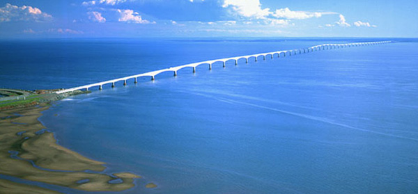
This is an aerial photo from the ConfederationBridge.com site:
If you do a Google search of the bridge and click on one of the
images you'll be directed to a page with dozens of photos of the bridge.
Here are two of my photos as we crossed the lengthy bridge:

We're back to both English and
French on signs; this one says no cell phone usage while driving.

Water, water everywhere across the strait but on a
sunny day you can see land at both ends of the bridge.
The Confederation Bridge is the longest in the world that spans a
body of water that freezes over in the winter. It was built in the 1990s to
replace a ferry in that location and opened in 1997.
This bridge is the only vehicle link to the island during the winter and sometimes
it closes if it gets iced over. The ferry at Pictou doesn't run in the wintertime
when there are few to no visitors to the island and many residents have gone
south to avoid the cold. The ferry can't get through anyway if the strait is a sheet
of ice.
Our bottom line: PEI is a lovely place
to visit or live when the weather is nice, but not so hospitable or convenient
in the winter!
WELCOME TO PEI
"Confederation" this, "Confederation" that. Even the vehicle tags
emphasize that PEI is the birthplace of the Canadian Confederation of
provinces:

We'd see a lot of this word on the island because 2014 marks the 150th anniversary
of the Charlottetown, PEI Conference. In 1864 the Fathers of
Confederation met at Province House to discuss the formation of the
nation of Canada.
The province has numerous events and activities commemorating the
anniversary. I'll talk more about some of them in another entry.
We stopped at the very nice Gateway Village visitor center on the
island at the northern end of the Confederation Bridge to get more information
before traveling further:


After we got settled in at our campsite we spent a couple hours reading
through the PEI guidebook and learning more about the cycling trails,
etc. PEI is the smallest Canadian province in size (not population) but
there are a lot of things to do and see that interest us.
Once on PEI we had to override the GPS several times. It kept
directing us off CA 1 to little country roads that probably would have
been shorter to the campground near Harrington, which is NW of Charlottetown
(the capital of the province), but we stuck to more major roads with the Cameo.
The roads we took were scenic. Like Nova Scotia, PEI is also known
for its fertile valleys, lovely coastal views, and little fishing villages.
We're looking forward to taking day trips all over the island to see
what it has to offer.

Nice view of the bay as we
approached Charlottetown
All the roads we took were good except parts of NS 217 on Digby Neck
but that was the only way to get to and from Whale Cove in a vehicle.
Our only complaint about the freeways in the Maritimes is the lack of
rest areas like we have in the States. Perhaps that is so travelers will
be forced to go into nearby towns??
The only real rest area we've seen so far up here is the one at Amherst, NS and
it's better than most in the U.S. We stopped there again on our
way to PEI, just because it's special.
We followed the campground's directions rather than our GPS and found
the place rather easily. It'll be our home base for the next week as we
explore the island.
Next entry: all about Pine Hills RV Park near Charlottetown, PEI
Happy trails,
Sue
"Runtrails & Company" - Sue Norwood, Jim O'Neil,
Cody the ultra Lab, and Casey-pup
Previous
Next
© 2014 Sue Norwood and Jim O'Neil
