Brier Island is indeed in a precarious position at the entrance/exit to
the Bay of Fundy, through which an enormous amount of water flows in and
out every twelve hours.
As mentioned previously, the tides in this large bay are some of, if not
the, highest in the world, topping out at about 52 feet at
the northern end of the bay in the Hopewell Rocks and Minas Basin areas.
At the lower end of the bay the tidal variance is "only" about 22 feet,
still a significant amount.
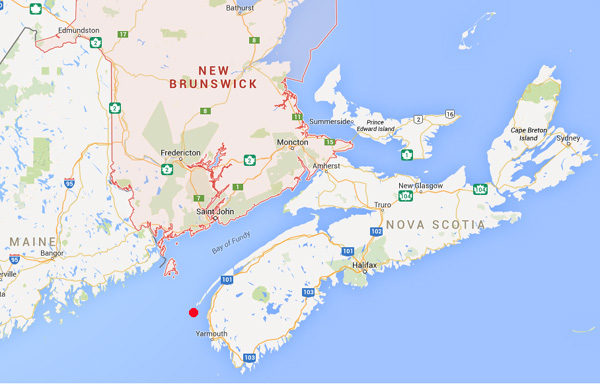
This map shows the relationship of Brier Island (just above the red dot)
to the rest of Nova Scotia, New Brunswick, Maine, and the infamous Bay
of Fundy:
Today we took the dogs with us to explore Long and Brier Islands, which
are located at the southern end of Digby Neck.
We had a fun day and saw two of the critical lighthouses on Brier Island
and one on Long Island.
FERRY ME OVER, FERRY ME THERE
Visiting these islands by vehicle involves taking a short ferry ride to
each island. The ferries are run by the Province of Nova Scotia. We got to ride
four times on today's out and back day trip (ditto for the next day's trip to Westport
for the whale cruise).
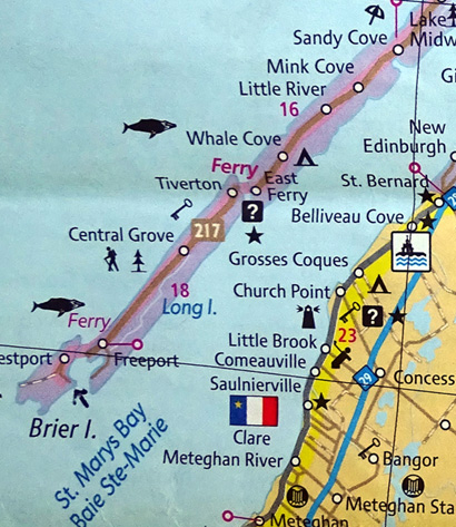
Here's the map again
of the southern end of Digby Neck and the two islands:
The first ferry goes from the tiny town of East Ferry at the end of
Digby Neck to the town of Tiverton on Long Island.
It leaves on the half hour each hour (i.e., 8:30, 9:30, 10:30). It's a
short ride across Petit Passage, taking only about
three minutes once the ferry starts moving.
If there are too many vehicles for a crossing, the ferry will come back
and take the remainder that were there on time. It holds about 21
vehicles three abreast, or fewer if there are any RVs or commercial
trucks on board.
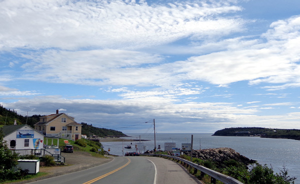
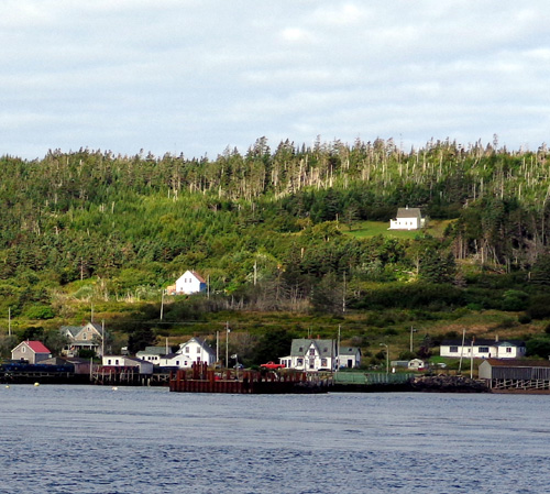
View of East Ferry and Petit Passage when we checked it out yesterday
afternoon;
the northern end of Long Island is visible on the right.
Long Island is about 11 miles long and 2˝-3 miles wide; NS 217, a
nice paved road, goes right through the middle of it. If someone is on
their way to Brier Island, they can drive those 11 miles fast enough to
get to the next ferry that goes between Long and Brier Islands every
hour on the hour.
That ferry is smaller and can't carry larger RVs because they'd bottom
out at the bottom of the ramp in either direction, especially when the
tide is lower (the ramp rises and falls with the tide). Although Grand
Passage is wider than Petit Passage, the ferry ride there takes only
about five minutes between the towns of Freeport on Long Island and
Westport on Brier Island.
Brier Island is the end of the line. There are some more little islands
at the SW end of Brier Island but they aren't inhabited by humans.
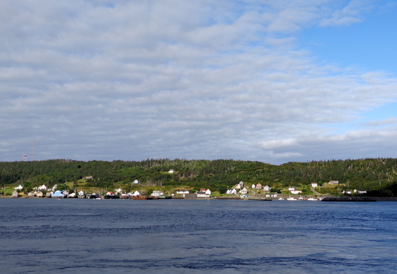
Above and below: view of Tiverton from East Ferry while we waited
for our ferry across Petit Passage this morning.
Each outbound ferry ride costs $5.50 for passenger vehicles and $6.50
for commercial vehicles. I don't know what RVs cost. The Class A that
was parked next to us last night at Whale Cove was on our ferry ride to
Long Island this morning and so were three smaller Class C motorhomes
from our campground. There is no charge on the return ferries.
We got a good tip from our campground hosts to purchase a "punch card"
for $13.50. It's more cost-effective for folks who plan to go out on three or more
ferry rides. It's $13.50 for ten punches, or ten outbound ferries. We got one
of those because we planned to take two out-bound trips to Long Island and two
to Brier Island = four punches. The ferry guys don't tell you that so we
were glad for the information (it's on the ferry system website,
though). Residents can purchase annual passes, which are less expensive.
We had six punches remaining on our card at the end of our stay. When we
left Whale Cove we gave our partially-used pass to the campground owners
to give to another visitor -- "paying forward," I guess you'd
say.
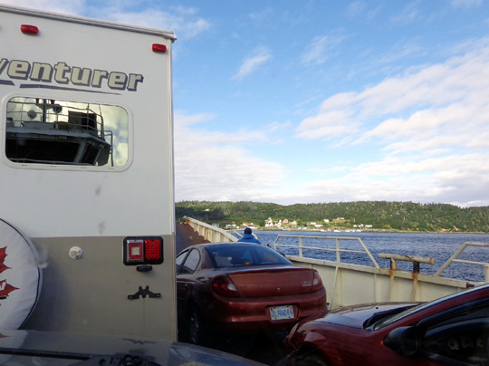
We got behind one of the RVs on the first ferry this morning between
East Ferry and
Long Island. I could have stepped outside the truck to take
photos with no obstructions
but I'd already gotten pictures across Petit Passage from
shore so it didn't matter.
Casey loved the two guys operating the second, smaller ferry between the
two islands; they gave her lots of attention in both directions.
LONG ISLAND: BOAR'S HEAD
LIGHTHOUSE
We got a list at our campground of about 20 things to do and see on the
islands. We did about half of them today.
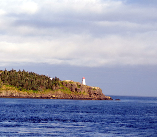
When we first got to Long Island we drove the opposite direction of
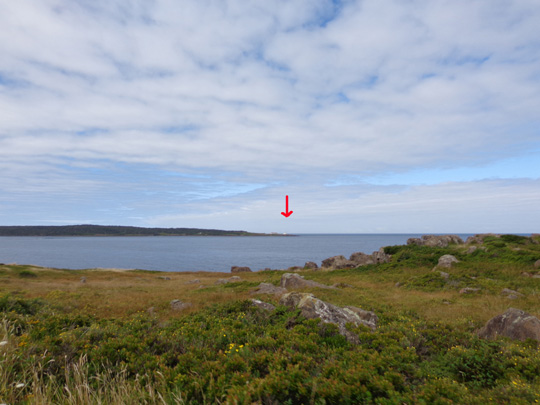
everyone else on our ferry -- right, to the lighthouse on Boars Head.
We could see it from East Ferry while we were waiting to board the ferry
across Petit Passage:
Good thing we went there when no one else did because the narrow gravel
road would be difficult to meet oncoming traffic and the parking area at
the overlook was very small.
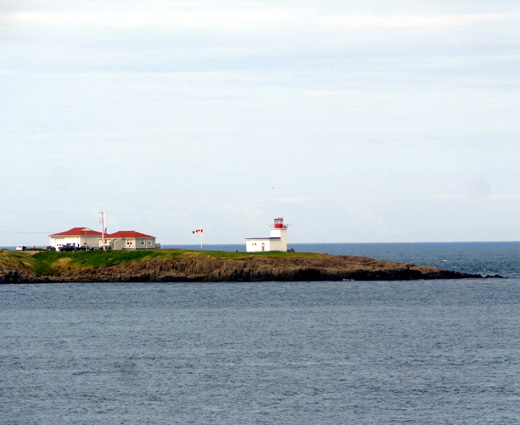
Although the lighthouse is located in what appears to be a critical
location at the northern entrance to Petit Passage, it is no longer in
service. It is maintained by a non-profit organization for visitors to
enjoy.
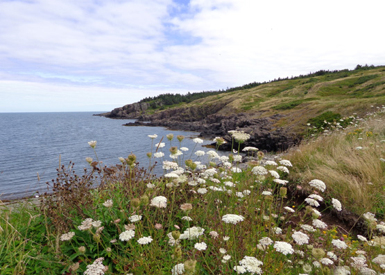
Since no one else was there we let the dogs
run loose as we climbed over the grass and rocks for different views of
the lighthouse, Bay of Fundy, and Petit Passage:
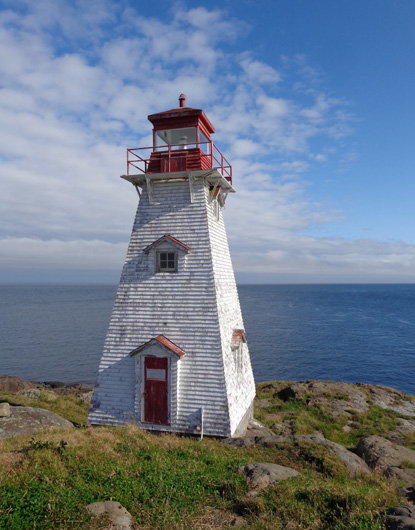
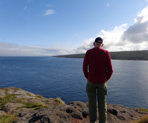
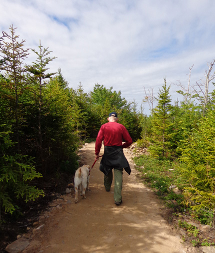
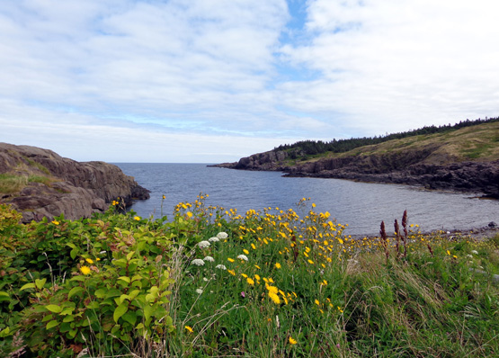
Jim looks out to the northern entrance to Petit
Passage.
Nice place to eat lunch -- overlooking the Bay of
Fundy -- but it was too early for us.
Our next stop was at Long Island's small visitor center for a good map of the
islands and a tide chart. High tide was about 10:35 AM, about half an hour
after I picked up the chart.
LONG ISLAND: BALANCING ROCK
Then we went to Balancing Rock, a tall columnar formation on the St.
Mary's Bay side of the island. Promotional literature describes it as "a
spectacular basalt sea stack that rests precariously on its end:"
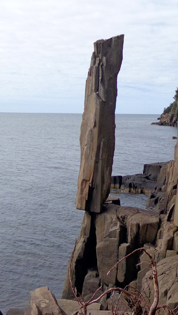
I haven't read its exact height but I'd guess it's about 12 feet tall.
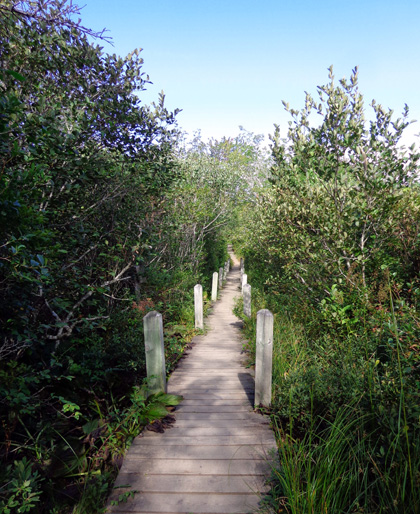
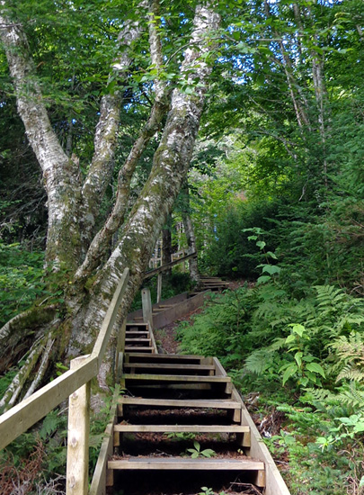
Visitors reach the formation at the end of a 1.25-mile trail that
goes through a bog, woodlands, and down a steep embankment. The first mile
of the trail goes through wet areas on boardwalks
. . .
. . . and on dirt and gravel
paths through low treed areas with balsam fir, hemlocks, black spruce,
and various deciduous trees and shrubs:
There are some interpretive signs
along the way.
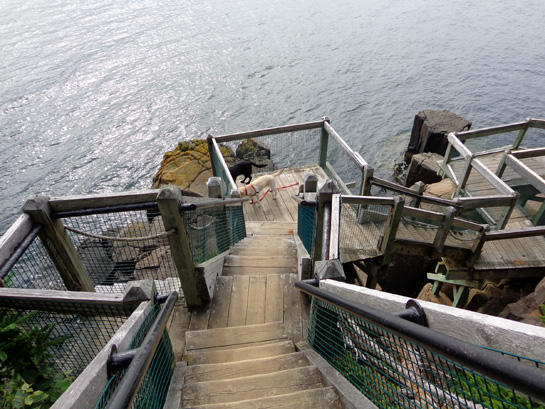
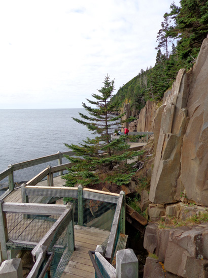
The last quarter mile goes down quite
a steep grade on 235 wooden steps. Balancing Rock is visible from a
nearby observation deck at the bottom of all the steps:
The lower steps and landings are
fenced in for safety:
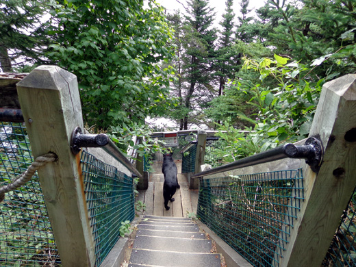
Steeper the rest of the way down, so they added the
fencing for safety.
Jim and the dogs beat me down the steps because I
kept pausing to take pictures.
Almost there . . .
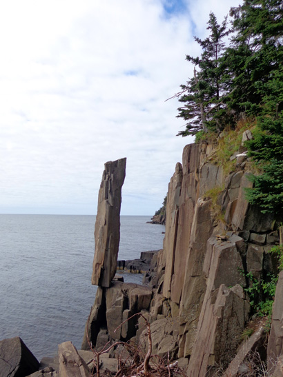
Balancing Rock
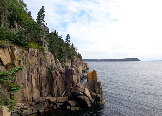
View of rocks the other direction
Our timing was good at Balancing Rock, too. Although we met a few folks
on the path to and from the shoreline, no one was at the featured rock
when we got there.
It was also good timing re: the tide because it was high when we
got down to the rocks on St. Mary's Bay. It would be interesting to see
the rocks when the tide is low (tides are about 22 feet high here and at the
Bay of Fundy on the other side of the island ) but neither one of us
wanted to go up and down all those stairs again; going down is tough on
our aging knees.
Going back up wasn't a problem:
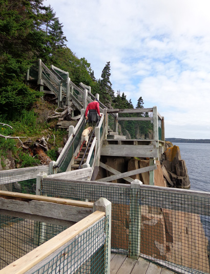
The steps are a huge improvement over the ropes that were used as
recently as ten years ago, per one of the couples we talked with on our
way out.
The lower stair section is very steep -- can't imagine
negotiating it with just ropes!
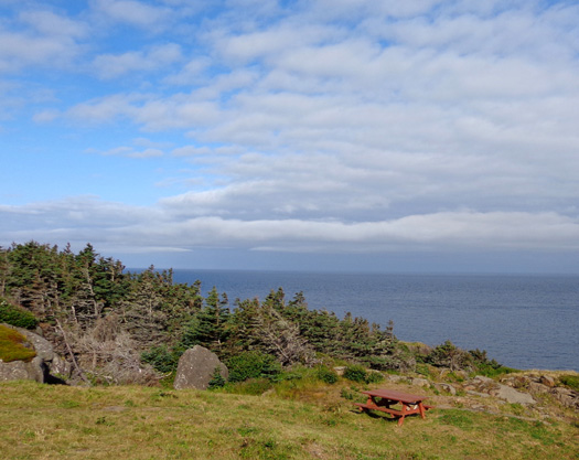
LONG ISLAND: BEAUTIFUL COVE
The dogs also got to run around for a few minutes at Beautiful Cove,
near Freeport at the SW end of Long Island.
How could we not go see an easily-accessed cove named "beautiful"??
You can drive right to it.
This pretty cove is popular with rock hounds for its quartz, agate, and
crystal rocks on its shoreline. I did pick up some pretty rocks for my
collection but I don't think they were those varieties. The tide was
still pretty high and I had a limited selection of colorful rocks. The
ones I chose were under water, where they were more colorful.
We climbed up a small
hill on the bay side of the hill to see the views from there. We were
close enough to Brier Island to see the lighthouse at Boar's Head (more
about it later):
Casey got to play with a local dog whose owner drove up while we were
at Beautiful Cove. The dog was running along the dirt road to the cove and the owner
was driving his truck slowly alongside.
Continued on the next
page: exploring Brier Island -- lots to see and do
there, too!
Happy trails,
Sue
"Runtrails & Company" - Sue Norwood, Jim O'Neil,
Cody the ultra Lab, and Casey-pup
Previous
Next
© 2014 Sue Norwood and Jim O'Neil
