(Continued from p. 3.)I'll wrap up this series of photos with more
scenes from Anchorage and Denali National Park.
ALONG THE COASTAL TRAIL
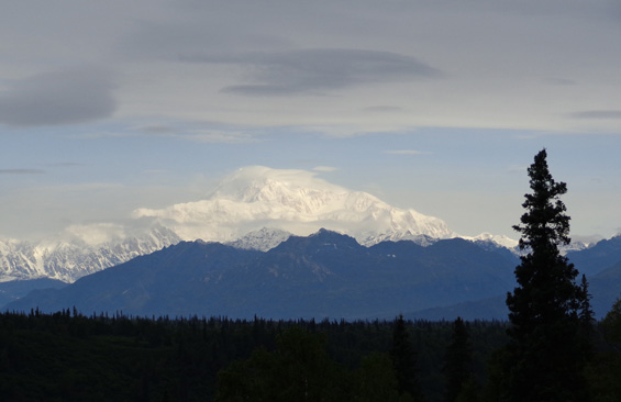
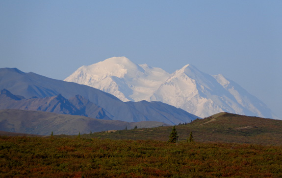
Here's a picture linking the two places -- a view north to Denali from the
Coastal Trail in Anchorage, over 100 air miles away!
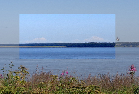
Mt. Foraker (L), 17,000+ feet
tall, and Mt. McKinley AKA Denali (R), 20, 320 feet tall.
(7-26-12)
Much of the time it's too cloudy over Denali to see it from
Anchorage. We were thrilled with that view.
More often we could see several closer 10,000-11,000-foot volcanic mountains
(Spur, Redoubt, and Iliamna) southwest of
Anchorage from this high point near Point Woronzof on the Coastal Trail:
You can see the snow-covered mountain range just above the horizon in
that picture.
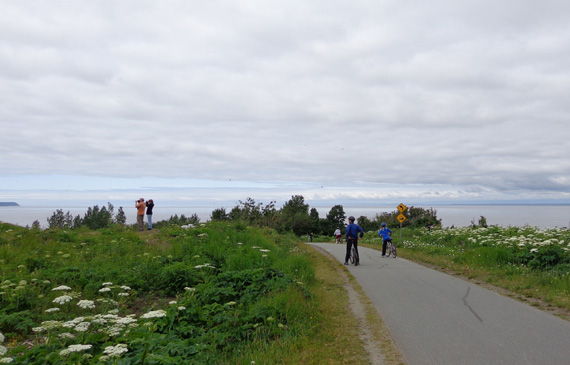
At that point on the Coastal Trail we were also sometimes right under airplanes coming and going from the airport!
The runways were only a few hundred yards away. The folks above are watching an airplane out of view of this shot I took
on June 29.
The 11-mile paved Tony Knowles Coastal Trail is one of our favorite
places in Anchorage. It follows the curves around Cook Inlet on the
western shore of Anchorage. We rode it many times. Jim often did longer
rides, linking to it from our campground at JBER (Joint Base
Elmendorf-Richardson) or from the Campbell Creek or Chestnut Creek bike
trails.
This is another picture I took from the trail recently, showing a tug
boat pushing a barge up Cook Inlet toward Anchorage's shipping port:
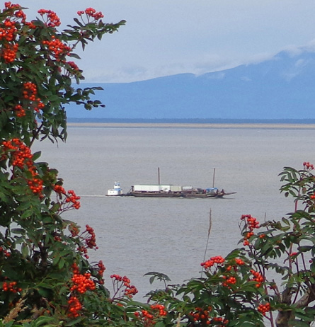
Those are berries on the tree, not flowers. Several kinds of red berries
are growing in the Anchorage area late this summer.
SOME OTHER FAVORITE PLACES TO PLAY
Anchorage is an outdoor enthusiast's dream city. Not only does it have
more miles of bike paths and multi-use trails per capita than any other
U.S. city, it is also full of public parks and surrounded by five or six
different mountain ranges.
One day when Jim was riding his bike around town he found a visiting
half-size replica of the Viet Nam Wall at the Delaney Park Strip, which
extends several blocks through the middle of town:

One panel with names on the small version of the
Viet Nam Wall (6-30-12)
I took this picture of colorful flowers at another place in the park
while I was driving around town another day:
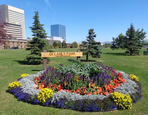
Delaney Park (7-27-12)
The City of Anchorage has a large botanical division that starts many
plants in greenhouses in the spring and then transplants them to flower
beds and pots all over town when temperatures warm up sufficiently. With
20+ hours of sun per day in June and July, they grow quite large and
really make the city look special.
For more strenuous recreational activities we literally headed to the
hills.
According to Alaska visitor information, the state's most popular mountain trail
is Flattop in the Chugach Mountains on the eastern side of
Anchorage. The upper part of the trail is gnarly,
climb-with-your-hands-over-the-rocks terrain but we still saw little kids
and older folks up on top.
I got this picture of Jim and Cody when they reached the summit:
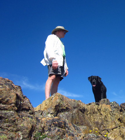
Come on up! The views are great! (6-22-12)
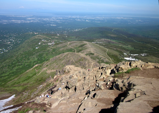
Flattop really is fairly flat on top. Hikers can spread out over several
acres and look down several thousand feet to the city and Cook Inlet
(next photo). To the east are more mountains in the range, many of them
still snow-capped in late June.
We spent half an hour or more wandering around the top of the mountain.
On the way down from Flattop I took this photo of some of the trails
emanating from the Glen Alps trailhead where we parked:
There are numerous other trails in the "hillside" system in the Chugach
Mountains. Some remain below tree line along streams and some go up to
mountain peaks and ridges in sub-alpine and alpine terrain.
My preference is to get above the trees so I can have more panoramic
views. In Alaska, that's usually safer, too -- I don't risk
surprising a bear when I can see everything around me. There have been a
number of bear incidents (i.e., maulings) in the Anchorage area this
summer.
RENDEZVOUS
My favorite trail in the Chugach Mountains is Rendezvous Ridge. Its trailhead at the Rendezvous
ski area is closer to JBER and the trails are all above tree line,
starting at 2,600 feet elevation.
The mountains I climbed near Rendezvous are all about 4,000 feet high.
The views from the peaks and from the ridges between them are
spectacular. I climbed up various ways five times this summer and was
able to see the city, water, and other mountains in the Chugach Range.
The views were spectacular in every direction.
The first time I climbed in the Rendezvous area there was still quite a
bit of snow:
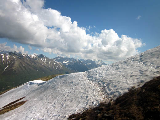
Snow on Rendezvous Ridge 6-22-12
Some of the snow was still there in mid-July:
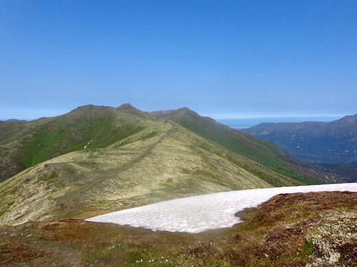
Still some snow on 7-19-12
That snow was finally gone when we went back to Anchorage in August,
although higher peaks in the range still had snow on top and in shady
places.
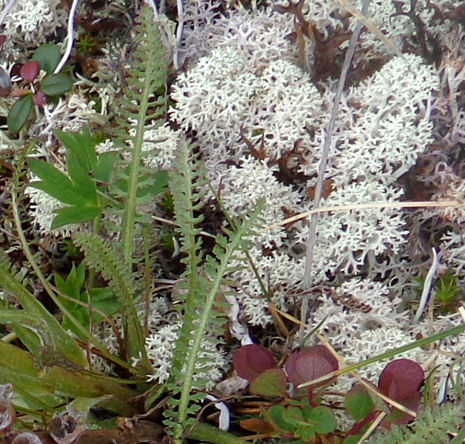
Note the red, green, and white plants in the tundra on Rendezvous
Ridge in the photo above. Here's a close-up photo of the white lichen and
some surrounding
tundra plants:
Two of the five times I hiked this ridge there were clouds moving in and
out -- very cool, since I knew where I was going and had seen the
views previously:
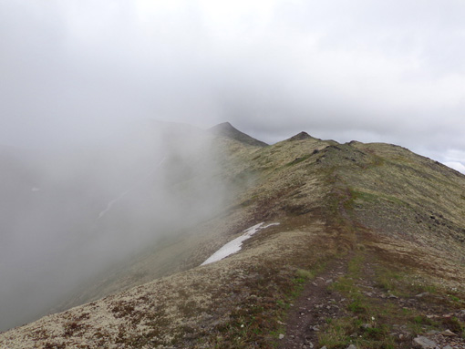
Into the mist (6-30-12)
That ridge reminded me of some of my favorite ridges in the Presidential
Range in New Hampshire.
THE PLETHORA OF MOOSE & BEARS IN ANCHORAGE
Believe it or not, the best place to see moose and black bears in
Alaska may be the city of Anchorage, home to about 300,000 residents
(and many more in the entire borough). We saw more moose in our
campground at JBER and along the Coastal Trail this summer than we did at Denali National Park or
along the highways!
I'd like you to meet a few more Anchorage moose and bears;
some were already shown in the first page of this entry.
The Coastal Trail is an extremely popular
multi-use trail. Despite all the people using it, moose and bears like
to hang out in the lush forest and coastline, too. We saw this mama bear and her three young cubs on our first visit to
Anchorage in late June:
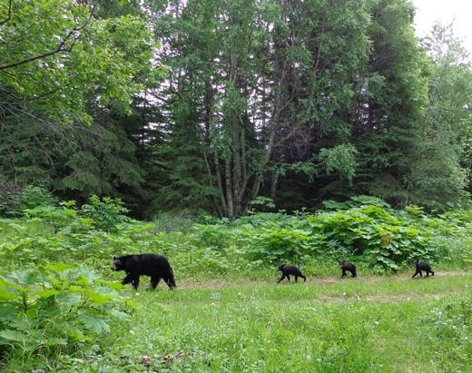
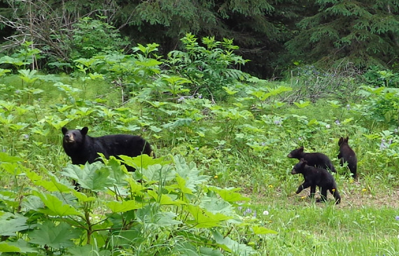
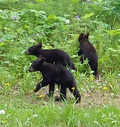
Unfortunately, on about a dozen bike rides on the trail later on we
never did see this family again.
On one of my first days riding my bike on the Coastal Trail I was surprised by this mama moose and her young calf right next
to the trail when I rounded a bend:
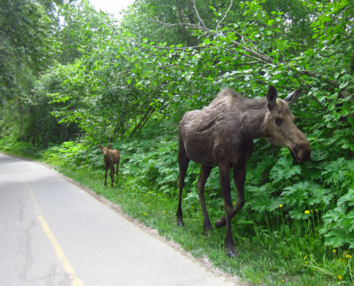
I slammed on the brakes, moved over as far left as I could, and
inched past the pair. Mrs. Moose mostly ignored me. The baby was more
skittish but quickly followed its mom. Jim was farther ahead of me and
missed this pair.
I never saw these particular moose again, either, but we saw several
others throughout the summer.
One day in August when I wasn't riding with Jim he saw this
one-antlered moose along the Coastal Trail:
Every moose we saw on the trail was aware of our presence but
nonchalant about it.
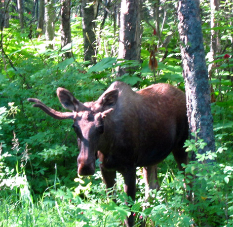
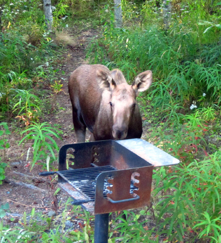
We also had "camp bears" and "camp moose" at JBER. I showed
a picture of one of
the bears in the first page of this series. Here are some of the moose
that came very close to our camper, even when we were outside:
Female moose with no calf visible
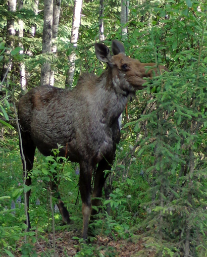
We first saw another female moose with her twins in June.
When we saw the same family in July and August we were thrilled to see
how much the calves had grown each time. This picture of one of the calves is
from August:
Curious calf
Baby birds are cute, too.
One day we visited Potter's Marsh, a large bird refuge just
south of Anchorage on the busy Seward Highway. The road
separates the marsh from the water in Turnagain Arm. This is a
popular resting stop for birds that migrate in the spring and
fall.
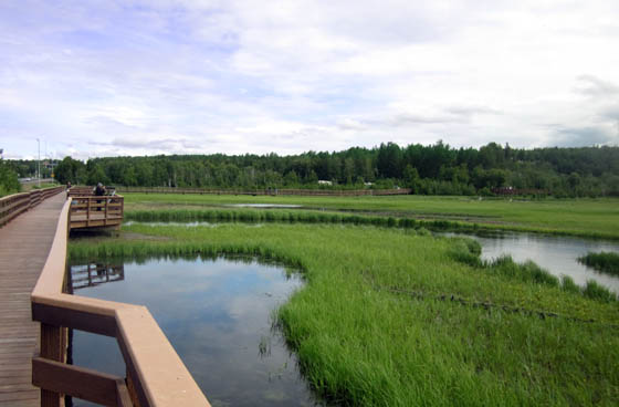
The marsh has long boardwalks so visitors
can get close to the birds and other
wildlife, such as moose, that inhabit the
wetlands. (6-27-12)
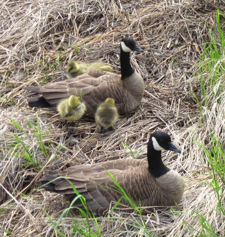
All four ducklings were under mom's wings
when we saw them ten minutes later.
DENALI NATIONAL PARK
I have some more scenery and wildlife photos to show you from
Denali National Park, too.
As I mentioned in the first page of this entry, we liked the
park so much after spending eleven days there in August, we went
back again for eight more days before Labor Day to enjoy the
fall colors.
The first three pictures in the group below are from our first
trip to Denali.
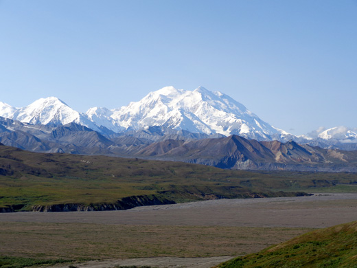
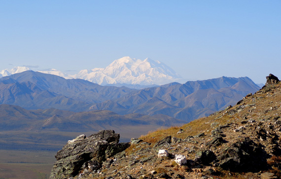
We got some good views of the mountain on our way to
the park from Anchorage on August 5. After several days of rain
in the area just before that, we lucked out with a sunnier day and could see the
peak from MP 135 on the George Parks Highway:
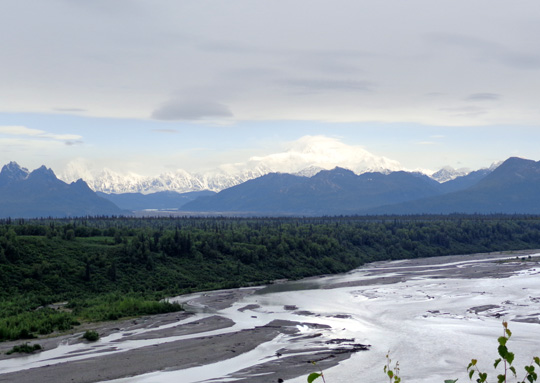
Above and below: view of Denali over the Chulitna River
(8-5-12)
We were also fortunate while staying at Denali the first time to
see the mountain from various vantage points nearly every day we
were there.
The closest views were from the Eielson Visitor Center area
66 miles into the park. Although Denali is 35 miles away from
the visitor center it looks
much closer to the naked eye:
View of The High One from Eielson Visitor
Center (8-9-12)
I climbed up the steep trail to the mountain across the road
from the visitor center once each time we were in the park and
got some good shots of Denali both times.
This is a picture looking down 1,000+ feet to the visitor center
and across to Mt. Eielson:
I took that photo on August 29 after snow had fallen down to
about 3,000 feet. By the next day, the new snow had melted. Much
of the snow in the Alaska Range remains there all year long,
however.
I spent about an hour on the ridge waiting for Denali to appear
from under the clouds. I finally saw it again as I was descending to
the visitor center:
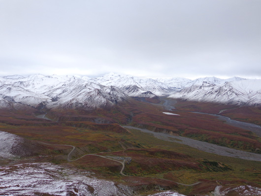
We also got some good views of Denali various times from the Savage River area
15 miles into the park.
I took this picture from the road as I was walking up to
the Mt. Margaret trailhead on August 15:
The taiga (sub-alpine) plants were already starting to turn red
by then. That was near the end of our first visit.
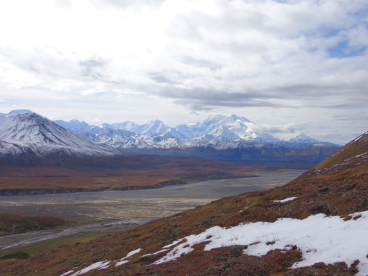
The views were spectacular that day from the ridge up to Mt. Margaret's
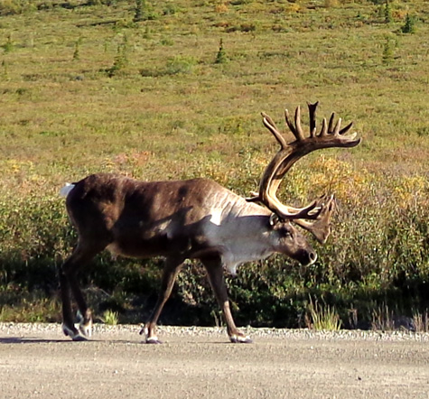
peak, not only toward Denali but in every direction:
That was the day I saw two male caribou and a moose as I walked along
the park road to reach the trailhead at the Primrose overlook.
Here's one of the caribou:
This is the female moose, who was checking out a critter cam in the
willows:
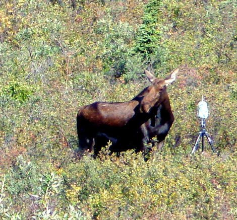
Smile!!!
I didn't notice the camera until I downloaded these pictures.
That's pretty funny!
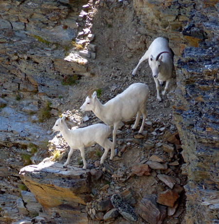
I also got close to some Dall sheep up on Mt. Margaret in the
rocky ledges:
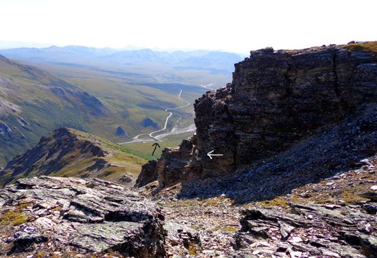
My truck's parked at the black arrow but
it's a 3˝-mile hike to get back there; two adult sheep
and a lamb are in the rocks at the
white arrow (close-up below). (8-15-12)
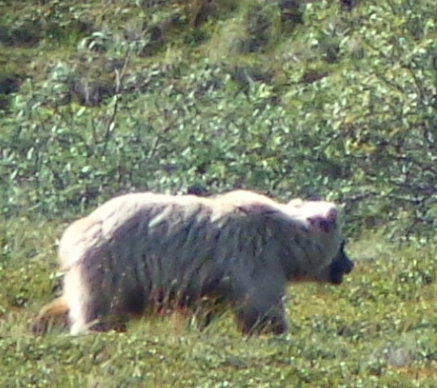
On our shuttle bus ride out to Wonder Lake we were able to watch
this large blonde-colored grizzly bear walking through a meadow
about 50 yards away. The bus driver stopped for about five
minutes as the bear remained in view:
On another of my favorite hikes at Denali, the Mt. Healy
Overlook Trail, I didn't see any large wildlife either time I
climbed up to the ridge but I sure enjoyed the trail and the
views:
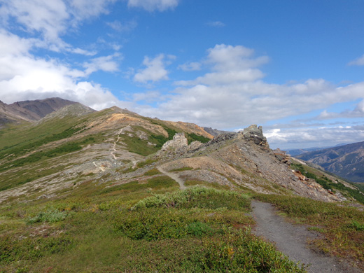
Trail on Healy Ridge near the entrance to
Denali National Park (8-6-12)
The maintained trail ends at the overlook. Both times I followed
the ridge for another mile before turning around. The
"un-maintained" trail up there was easier to walk than the
"maintained" one!
The last time I was up there, September 2, the tundra plants
were a kaleidoscope of reds, oranges, golds, and greens. The
colors had changed dramatically. I feasted on wild
blueberries until the cold wind drove me back down to the
campground. The blueberries were quite tasty after surviving the first
frost and snowfall, which had melted by the time I hiked up there.
END OF SUMMER
It's hard to believe that our trip to Alaska is almost over.
Fall has come quickly, as you can see from some of the photos in
this series of pages. We've got to get out of here
before it gets too cold for camping.
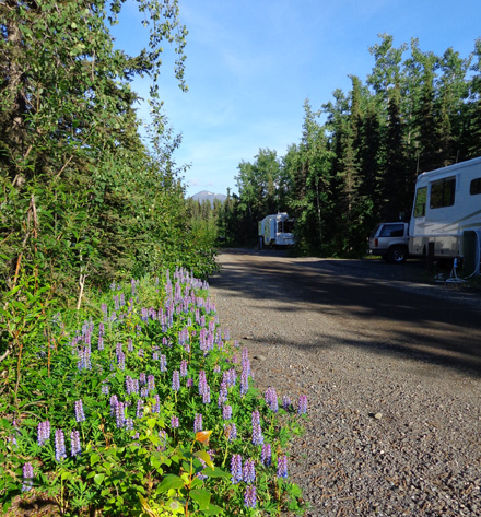
Here's an example of how fast summer flies in Alaska.
When we first arrived at JBER in late June the lupines were at
or near peak bloom. These were close to our camper (it's in the
distance below):
When we went back in late July the lupine blossoms were already
dying, replaced by fuzzy green things. On our third stay at the
campground in late August, all that was left were the lower green
leaves, which were turning yellow.
Those big cow parsnips like the ones in a photo a couple pages
back looked even worse by August. The white
flowers, tall stems, and green leaves were all brown. Yuck.
Fireweeds fare better as they loose their bright pink blooms.
The stems and leaves turn red and white fluff surrounds them,
glistening in the sun.
Here's one last shot from Denali.
Jim took this awesome picture, which looks like an oil painting, from a
hill on the park road while he was riding his bike one day. It looks
down to the Alaska RR trestle over Riley Creek in the "front
country" of the park near our campground:
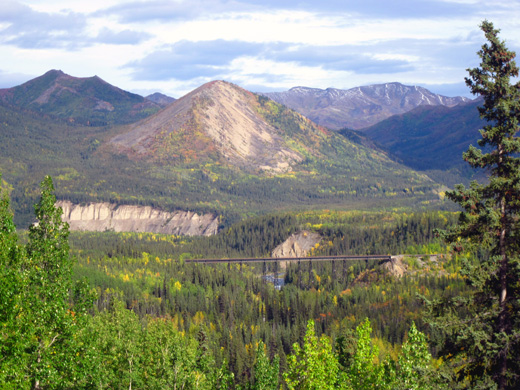
Although he took that picture on August 29 most of the trees in
it are
still green. That's because this is about the lowest elevation
in the park, not up in the taiga or tundra where the colors were
changing faster. Only a few days later when I was on Mt. Healy
and looking down on Riley Creek many of the aspen leaves in this view had turned gold or orange,
however.
Soon we'll be on our way back to the Lower 48. One of these days
I'll get around to posting the details of this trip, complete
with hundreds of the thousands of photos we took in Alaska and
Canada this summer.
Thank you for your loyalty and patience!
Addendum Nov. 3, 2013: new
entries are coming this week! The next ones will describe how we
spent two rainy days at Denali and my last hike on the now very
colorful Healy Ridge.
Happy trails,
Sue
"Runtrails & Company" - Sue Norwood, Jim O'Neil,
and Cody the ultra Lab
Previous
Next
© 2012 Sue Norwood and Jim O'Neil
