(Continued from the last page.)I'll show the remaining photos more by category than by place or in
chronological order, mainly because we zig-zagged around the South Central part of the state
between three visits to Anchorage and two to Denali NP.
The text and pictures might be more meaningful if you have a map of
Alaska to reference so you can see the locations I'm talking about.
WATER & ICE: GLACIERS, ICE FIELDS, & SEA CRITTERS
One of many things that makes Alaska different from the other 49
states is its abundance of
glaciers and ice fields. There are
several hundred named glaciers in the state, with estimates of up to
100,000 unnamed ones. Many of them flow out of large sheets of
ice called ice fields.
One of the ice fields in Alaska, the
Harding Icefield in the Kenai
Mountains, covers about 700 square miles and is thousands of feet thick.
It is so deep that only the very tips of the mountains it covers poke
out of the snow-covered ice:
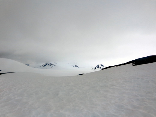
The Harding Icefield: into the abyss (7-7-12)
That's a bunch of ice!
Glaciers are constantly on the move, variously
advancing and retreating as they grind down the bedrock and soil beneath
them. Alaska is full of beautiful U-shaped valleys that were carved by
previous Ice Age glaciers.
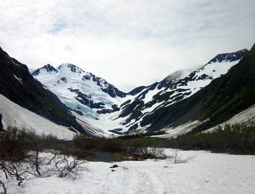
You can also sometimes see where a glacier
has more recently retreated, such as this valley below Exit Glacier near
Seward:
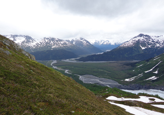
The blue ice on the right, above the two large
patches of snow, is the mouth of Exit Glacier.
The ridge of soil below it, where the ice has
receded, is called a terminal moraine.
It doesn't take very long for plants to cover the bare earth and
rocks that are left behind when glaciers retreat. In Alaska, bright pink
fireweed flowers, aspen trees, and other flora soon sprout.
Exit Glacier, flowing out of the Harding Icefield, is one of the glaciers
in Alaska that you can easily access by vehicle
and on foot.
The Kenai Fjords NP road leading to the Exit Glacier nature center has several signs showing how
far the ice extended in the late 1800s. The pathways to the lower part of the
glacier have signs showing more recent stages, decade by decade. On the
lower trails we were able to get right up next to the ice:
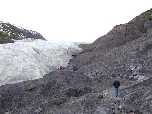
Jim walks toward Exit Glacier.
(7-6-12)
You can see the bare rocks in the photo above where the glacier has recently retreated. In time that
area will either be covered with plants -- or more ice! That can
happen, too.
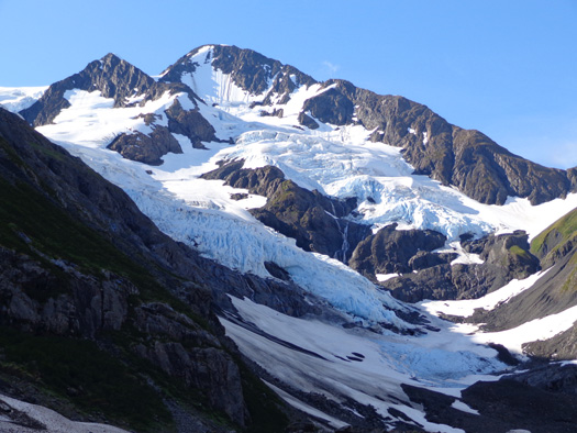
Even though it has dramatically retreated in the last century, Exit Glacier still extends several miles down from the huge
Harding Icefield, which is also
accessible on foot. One of my most memorable hikes this summer was
climbing 4˝ miles up the steep trail
next to the glacier, all the way to the edge of the ice field.
The views of the glacier (below) and the valley (two photos up) were
incredible as I climbed toward the ice field.
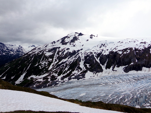
The minerals in glacial silt
cause glaciers to
look blue. They also give
glacial lakes and streams a beautiful deep blue or
turquoise color.
Even more incredible were the views out to the ice field when I
reached the end of the trail. That was
definitely a first for me, almost surreal. I'm just sorry Jim's bum knee
wouldn't allow him to hike up there and see that spectacle.
Everything in front of me was white except a few rock outcroppings
where the snow had melted. Those are the tips of mountains that are
4,000 or more feet above sea level. You can see them in the first photo
on this page. Because of clouds on the horizon it was
difficult to see where the snow on top of the ice field ended and the
sky began. It was a sea of white, almost blinding despite no sunshine.
All this at only 3,800 feet elevation where I topped out.
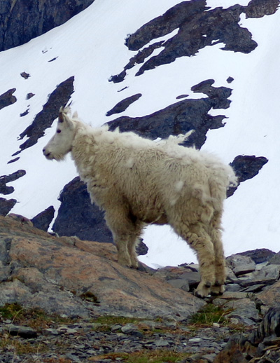
No one else was around for about 20 minutes as I wandered around and
shared the view with a shy Dall sheep shedding its undercoat:
Because of all the snow the South Central region of Alaska got last
year the last 2˝ miles of trail
were still buried. Usually the trail is clear most of the way up to the
ice field by now. The rangers had just cut a trail through the pristine
snow a few days earlier. More snow fell the night before I hiked but I
could still see the footprints.
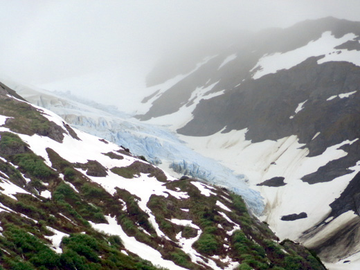
TRAIL OF BLUE ICE
There are numerous other glaciers in the Kenai Mountains. A good
place to view them is near the eastern end of Turnagain Arm in the
Portage Valley on the way to the town of Whittier.
This is one of the larger glaciers
that you can see from the Seward Highway as you're driving east and south
toward Portage:
Spencer Glacier and a couple of others in the
northern Kenai Mountain Range (7-2-12)
Some of the glaciers in this area are "hanging
glaciers." This is Middle Glacier, which hangs in the V between two
mountains above Williwaw Campground in the Portage Valley:
We could see that one from our campsite at Williwaw, and two other
hanging glaciers above the scenic Trail of Blue Ice.
This five-mile long
bike-hike path cost a bundle to build with all of its handsome bridges
and boardwalks but it's a very popular attraction for tourists and
residents:
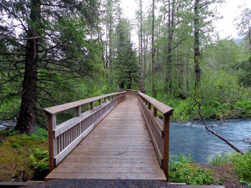
This is one of many beautiful
blue glacial streams in Portage Valley. (7-15-12)
Even though Jim and I have seen numerous glaciers from the road and
have been up close to several of them, I don't think I'll ever tire of
seeing them. Each one is different.
I enjoyed seeing Byron Glacier in the Portage Valley so much in early
July that I talked Jim into driving back down there on a day trip the
last time we were in Anchorage. The one-mile trail was still partly
snowed under on June 27 . . .
. . . but completely dry two months later:
I was able to get closer to the mouth of the glacier the second time
without fear of falling through the snow into icy water or a crevass.
TIDEWATER GLACIERS
Although the constant movement of glaciers is imperceptible to the
eye you can sometimes hear them, especially when they "calve."
Huge
chunks of ice periodically break off the edges of glaciers that extend
down to lakes or open water on coastlines, creating loud cracking
noises, icebergs in a variety of sizes, the potential for dangerous waves, and
the certainty of lots of ooh's and ahh's from
excited tourists!
This phenomenon is called calving. We've seen it in films and
in person but I wasn't able to capture it with my camera.
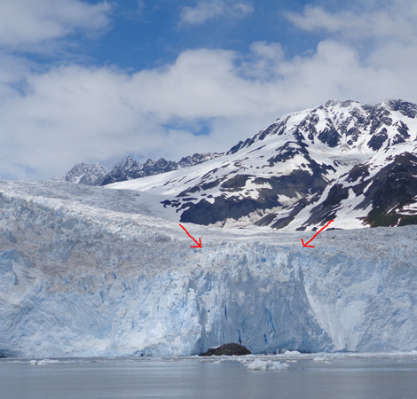
This section of Aialik Glacier
marked with arrows is about 300 feet deep and probably
"calved" after our boat left the
area. We saw a smaller section break off. (7-9-12)
One of our more memorable activities this summer was the 6˝-hour
narrated catamaran cruise we took out of Seward harbor to Kenai Fjords
National Park. We chose that particular tour out of many that are
offered because it took us to the very large Aialik Glacier, one of many
tidewater glaciers flowing from the Harding Icefield.
Jim took this picture of me as we were waiting patiently for the glacier to
calve again:
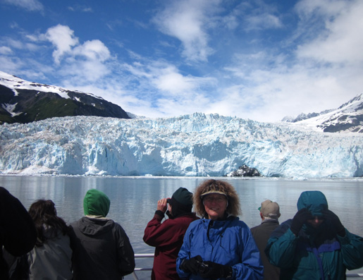
Although we saw several other glaciers on this tour Aialik was the
main attraction. The captain "parked" about half a mile out in the fjord
for about 20 minutes so we could safely watch the glacier calve and pass around
some pieces of ice from it. The deepest part of the face of that glacier is about 400
feet high.
CRUISIN'
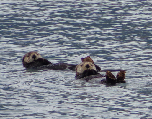
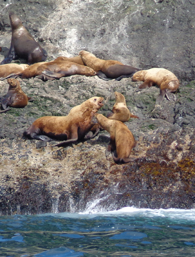
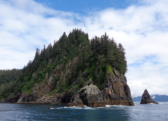
We saw many sea creatures on this tour through Resurrection Bay and
the southern portion of Prince William Sound -- adorable sea otters
floating on their backs,
humpback whales spouting off and diving into the water with their
distinctive tails submerging last, Stellar sea lions "barking" at each
other as they competed for the best spot on the rocks,
rock ledges full of nesting sea birds like kittiwakes and puffins:
I took this close-up shot of a puffin at the Sea Life Center in
Seward:
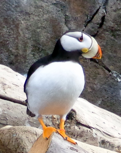
Puffins are some of the most interesting birds we've ever watched.
Out in the Sound they looked very awkward when they tried to fly,
reminding me of huge Air Force cargo planes
that don't look like they could possibly fly. The plump birds flap their
wings real hard and finally get airborne above the water.
But you should see them under water -- puffins can swim
amazingly fast. They are fascinating to observe.
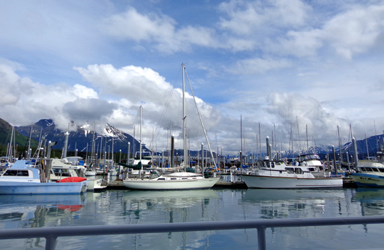
OTHER SEWARD PHOTOS
We arrived in scenic Seward just after the July 4 holiday ended and
the crowds had gone. Seward sounds like a madhouse then and we didn't
want anything to do with it.
We spent six enjoyable days in Seward. Like Valdez at the northern
end of Prince William Sound, Seward is surrounded by mountains and
water. One of our favorite places to cycle and walk was along the small
boat harbor:
The mountains beckoned to me, too. I had to take a hike on Mt.
Marathon, which towers over the little seaport town. I wasn't interested
in an organized event, however. I don't race any more.
One of the July 4th attractions is the grueling Mt. Marathon foot
race. Although it is short (about three miles up the mountain and back
down) it is notorious for its difficulty and it draws trail runners like
flies to honey from around the world.
Some runners have previously gotten seriously injured from falling
down the loose rocks as they bombed back down the mountain during the
race but this was the first year someone apparently died up there. The
last runner to the top, a man from Anchorage, never made it back down
and still hasn't been found. (It's highly unlikely this man planned his
disappearance.) Another younger runner remains hospitalized from serious
injuries he incurred.
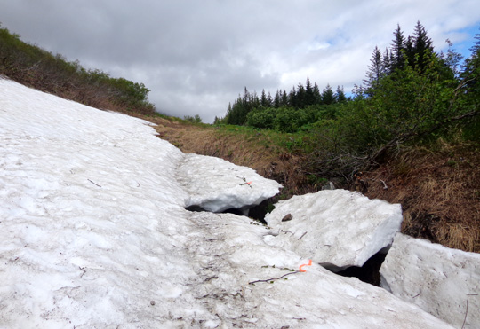
Ribbons mark snow over a creek on
Mt. Marathon where searchers
already looked for the missing
runner. (7-10-12)
We arrived in Seward the day after this happened. For several days the
mountain was closed to everyone but official search crews who marked
each section they searched (colored ribbons above).
Once the trails were opened back up for hiking I attempted to go up
another trail on the mountain. As you can see in the photo above, there
was still a lot of snow the second week of July -- at just a few
hundred feet above sea level! All of South Central Alaska really got dumped on last winter.
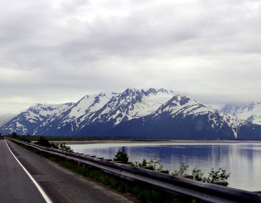
ALONG THE SEWARD HIGHWAY
The road that leads down the east side of the Kenai Peninsula to
Seward is called, appropriately, the Seward Highway. Seward is literally
at the end of the road, so after six days we had to retrace 37 miles of
the highway to get to our next destination.
This is a magnificent drive through beautiful mountains -- on
a sunny day. Unfortunately, on both legs of this out-and-back drive we
had overcast, misty weather and I couldn't get any good shots of the
stunning mountains around us.
The best I can do is show you these pretty lily pads at one of many
lakes along the road:
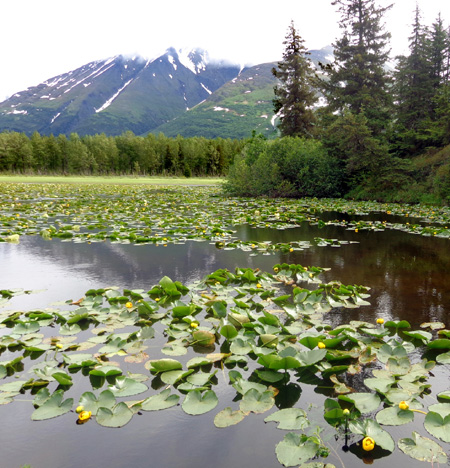
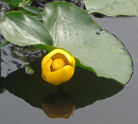
Despite all the lingering snow just above sea level we saw beautiful
wildflowers everywhere we went in the early summer.
Continued on the next page -- more wildlife and coastal scenes
from the Kenai Peninsula south of Anchorage and the Mat-Su Valley area
north of the city
Happy trails,
Sue
"Runtrails & Company" - Sue Norwood, Jim O'Neil,
and Cody the ultra Lab
Previous
Next
© 2012 Sue Norwood and Jim O'Neil
