Today we continued on the eastern access route
to Olds, AB. With flatter terrain and more four-lane roads, we had one
of our higher mileage days on this trip to and from Alaska.
We started at sunrise, which is getting later
rapidly as the Far North loses several minutes of daylight each day. The
days are noticeably shorter. We miss the long, long hours of daylight we
enjoyed so much in June and July in Alaska.
ROUTE:
AB 43 to AB 16 (Yellowhead Hwy.), around SW part of
Edmonton on new Anthony Henday Bypass/AB 216, and south on AB 2 toward
Calgary.
These map sections
are from The Milepost
website:
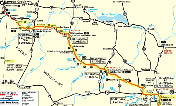
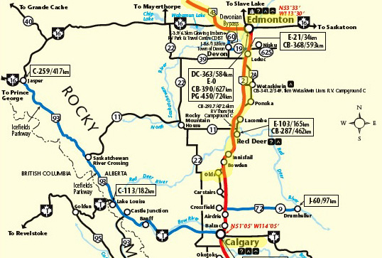
Most of AB 43 is four-lane from Grande Prairie to Edmonton. The freeways through Edmonton are six to
eight lanes wide. AB 2 between Edmonton and Calgary is four-lane and
mostly a limited-access freeway.
TRAFFIC:
fairly light until several miles west of Grande Prairie, then heavy through
that city of 50,000+ people since it was the morning rush hour(s). Moderate
traffic to Whitecourt (9,200 people), then increasingly heavy to Edmonton,
population 283,000.
Traffic was heavy in the Edmonton metro area even though we went through
after lunchtime. Traffic was also heavy all the way south of Edmonton on AB 2
toward Calgary. Most of that freeway is four-lane. It isn’t totally
limited access; there are some intersections without ramps so we
had to be more cautious for vehicles entering/getting off.
Despite the
conveniences of more populated areas we're also missing the solitude of
the wilderness already.
GETTING OFF-COURSE
Although it’s nice to have sunshine when we’re traveling it was a
problem going eastbound this morning after the sun got above the clouds.
When we got to Grande Prairie we couldn’t see the sign where AB 43 first
turned to the north and had to find our way to it on other city streets
with more traffic lights and stop signs. That didn’t add distance but it added
time and stress.
Missing a turn isn't
such a big deal if you get off-course in a passenger vehicle. When
you're pulling a 36-foot 5th-wheel coach it can possibly be a big deal.
We added distance and stress in Edmonton when we got goofed up at
the bypass around the southwest side of the city -- again. We messed
up here in early June going northbound, too, and I neglected to consult
my notes thoroughly enough before reaching the same intersection today.
The bypass and a major interchange have been built since our AAA map and our
2011Milepost book were printed, and we don’t have current Canadian information
on the GPS, either. Before we left Virginia in May Jim updated the USA information
but not both it and Canada – the unit won’t hold all the information for
both countries. We decided
in June that we'd rely on our maps and The Milepost for Canada. Except for Edmonton,
that's worked fine.
We got off AB 16 at 148th St., went south, and got diesel at Petro Pass at
118th St. I went inside for
information about how to get back to the bypass. A nice older
customer, who lives in the area, explained how to get there.
Then he went
outside to talk with Jim about pulling the Cameo
with our Ram 2500 diesel truck. The man has an older Ram and older trailer and wants to
upgrade both. He liked us enough to suggest that we just follow him because he
was going back to AB 16. He told us which exit to take south to get to
the Henday Bypass and AB 2.
That worked. It's nice to have the equivalent of a "trail angel" when
you're off-track in a big city!
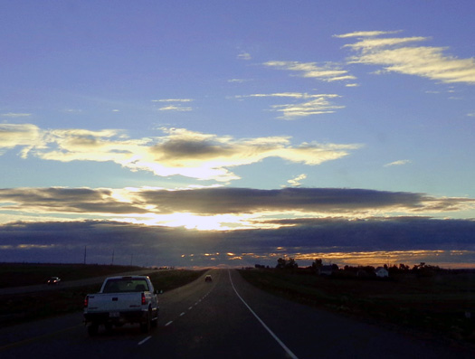
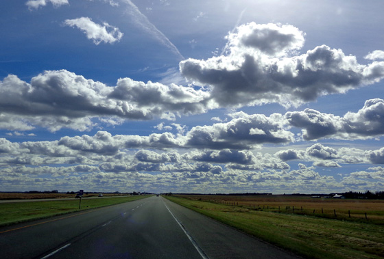
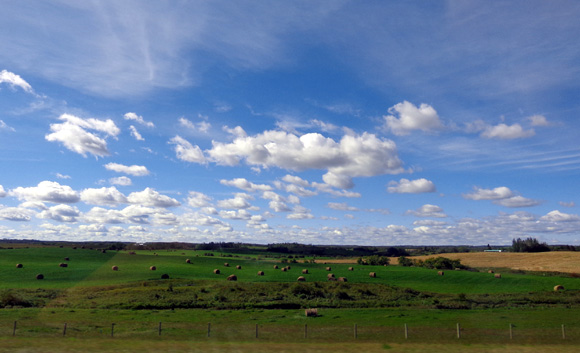
WEATHER: As you can see from the photos it was mostly sunny
today with lots of billowy white clouds. That was nice!
The sun helped keep us warmer on this chilly day. It was 41 F. this morning
in Hythe and only in the mid-50s F. this afternoon, which is cooler than
normal. The wind didn’t help. West winds helped push us along east to Edmonton but we had a strong side wind when going south from
there toward Calgary.
Frazz cartoon by Jef Mallett (10-16-11)
Although the weather hasn’t been ideal in each place we’ve traveled
going back to the Lower 48 -- and the main reason we didn’t go down the Cassiar
Hwy.
and through Banff and Jasper National Parks-- it’s a good thing we weren’t a day ahead
of where we are. Our timing was just right for today and tomorrow
through the southern half of Alberta.
Yesterday Calgary had winds of over 100 km (62 MPH)
and there were large grass fires west of Lethbridge and Milk Grass that
were fanned by the wind. Several thousand homeowners were evacuated.
That might have caused us trouble on our route through those cities.
The wind was less strong today and the evening news indicates the fires are
under control now. As far as we know there are no road closures that
will affect us tomorrow.
FUEL:
we paid $1.119/liter = $4.24 CA per gallon at Petro Pass in
Edmonton. That’s the same as the Flying J nearby. Most of the time stations
in Canada show only the gasoline prices. Sometimes diesel is more,
sometimes less. We will fill up in the morning in Olds, where diesel is $1.139/liter.
TERRAIN & CRITTERS
Although we could see the Rocky Mountains in the Jasper area from Hythe when
we left the campground this morning we lost sight of them in a few miles and
never did see them again. It was supposed to rain and/or snow there today.
It was supposed to be very cold tonight in that area, too, so I didn’t try to talk
Jim into a detour from Grande Prairie down the Bighorn Hwy. to Jasper.
I'd love to drive the Icefields Parkway someday. On a clear day that
scenic drive would be more
pleasant than all the traffic through Edmonton. Most of southern Alberta has frost warnings tonight,
including Olds, Calgary, Lethbridge, and down to the Montana border.
The terrain today wasn’t completely flat but it was certainly flatter than
most of our trip through Canada and Alaska. There was little to no fall
leaf color. Almost everything except the remaining wheat or chaff is green.
Oh, and there are still yellow dandelions and puffs at Olds!
The only critters we saw today were two pairs of deer in fields near the
road and a dead moose in the median a few miles west of Edmonton. We
saw lots of warning signs today for moose but there were no signs
anywhere near the location where the one was struck.
OVERNIGHT PARKING
We're at a Walmart for the first time since June. Can't exactly call that
"camping," can we?
Last evening Jim spent time determining where various Walmarts were
located on today’s route. Our sole source of information was the Rand
McNally
atlas that has Walmart and Sam's Club stores listed in the U.S. and
Canada. Included are addresses and the nearest freeway exits, but not
directions or store phone numbers.
As a side note, there are no Sam’s Clubs listed in the Walmart atlas for
any of the Canadian provinces. We saw a couple Costcos today from the
road; one is south of Red Deer on the west side of AB 2.
Jim
originally wanted to stop at the store in Leduc south of
Edmonton but we got there about 2:30 PM. That was not only earlier than
we wanted to stop today, it would
also mean too many remaining miles to reach Malmstrom AFB in Great Falls, MT
tomorrow. We don't have to be there tomorrow. Since we've been
able to get this far in six days we'd like to
avoid having to spend a seventh night on the road.
There are two Walmart stores in the Red Deer area between Edmonton and
Calgary. Neither is a super Walmart
and we didn’t have directions to either store (since we don't have the
GPS programmed for Canada). As it was, we didn’t see either one from the
freeway, nor intersections for the roads they’re on.
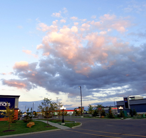
Sunset from the shopping area where we're parked
tonight
In the atlas I found a super Walmart at Olds and assumed it was near the
freeway. Turned out, it’s four or five miles west of the freeway in
town. It’s a small store but it has a large parking area and it
wasn’t at all crowded when we arrived about 4:25 PM.
There was just one small Class C motorhome parked out from the garden
area when we arrived. We parked along a grassy, treed strip. There are
lots of other stores around and plenty of traffic – but no freeway
noise. The store closed during the night so there was also less traffic
in the parking lot than at Walmarts that are open 24/7.
Before supper I took Cody for a walk behind the store in a large vacant field with a
hill we could climb. Jim got exercise on his bike when he drove around
town looking for diesel.
We were able to get TV stations from Calgary to hear local,
regional, and US news. This is the 11th
anniversary of 9-11. We didn't need a newscaster to remind us. Every year
we wake up on September 11 and remember that dark day in American history.
There was a nice sunset about 8 PM, then it got dark pretty fast. < sigh
>
Next entry: Day 7 on the journey south --
back in the USA!!
Happy trails,
Sue
"Runtrails & Company" - Sue Norwood, Jim O'Neil,
and Cody the ultra Lab
Previous
Next
© 2012 Sue Norwood and Jim O'Neil
