We have now driven all of the Glenn Highway between Tok and
Mile 0 in Anchorage, although we did it in two legs over four different
days -- Tok to Glennallen on our way to Valdez, and now
Glennallen to Anchorage.
Today was our shortest travel day since beginning our
Alaskan adventure back in May. The distance from our overnight stop at a
turnout near Sutton-Alpine and along the Matanuska River to the northern part of Anchorage
(the Black Spruce Campground at Fort Richardson) was
just 53 miles.
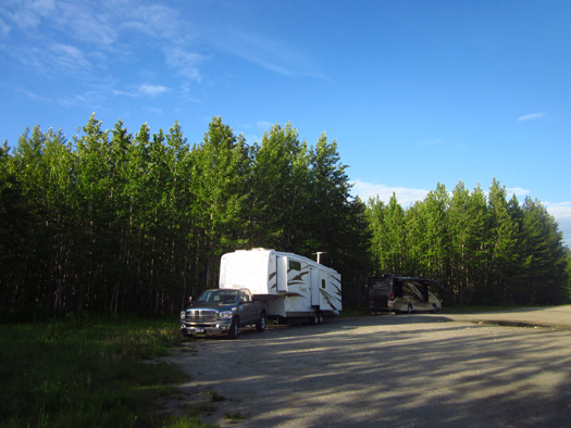
Where the Cameo started this
morning . . .
It was great! We like days like this and will be incorporating more of
them into our travel plans as we explore Alaska.
You'd think that wouldn't take much more than an hour on the paved Glenn
Highway but our stop to tour the Musk Ox Farm near Palmer this morning
turned the trip into several hours. We arrived at our campground at
lunch time and had the whole afternoon to begin exploring the base and
Anchorage.
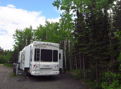
. . . Where the Cameo ended this
afternoon.
I wrote about the interesting musk ox farm tour in the last entry. This page
describes our route on the Glenn Highway from MM 63 to MM 8, the northern-most entrance
(Richardson Gate) to Joint Base Elmendorf-Richardson (JBER). The information
may be helpful to other travelers whether they are traveling in an RV,
passenger vehicle, or motorcycle.
(We drove the last -- or is that the first? -- eight
miles of the Glenn when we went into town this afternoon. Nothing
remarkable to note, just typical busy four-lane urban highway.)
ALONG THE GLENN HIGHWAY
The roads were pretty good today between MM 63 and MM 0, with no
construction.
This map section
taken from the 2011
Milepost book (p. 323) shows our
route, highlighted in yellow:
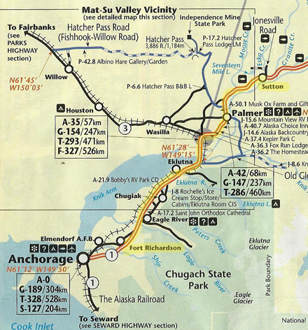
I'll be referring to several locations on that map in this entry.
The weather was great today – some clouds but mostly sunny and up to 70 F. in
Anchorage this afternoon. Perfect!
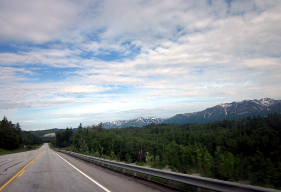
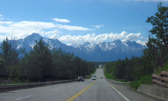
As we drove west from
Sutton-Alpine to the intersection with the Parks Highway at MM 36
we had nice views of the Chugach Mountains to the south and the Talkeetna Mountains to the north:
At MM 49 we
passed the junction with Palmer-Fishhook Road, which leads north to
Hatcher Pass Road and Independence Mine State Historic Park. That's
another destination on my list sometime this summer.
We drove
through the southern part of Palmer but didn't stop anywhere. We passed
the fairgrounds where the Alaska State Fair is held in late August-early
September. We'll either camp in the Palmer-Wasilla area for a few days
later this summer or visit the places we want to see in the Mat-Su
Valley on one or more day trips from
Anchorage.
Matanuska River east of Palmer
Traffic was moderate on the two- and three-lane sections of the Glenn
Hwy., then rather heavy as we turned to the south at MM 36 and
approached Anchorage on a four-lane divided freeway with ramps and
limited access.
We haven’t been on a real freeway for a couple of weeks, let alone in
a big city. Anchorage may have “only” 300,000 people but it feels big as
long as we’ve been in remote territory with much smaller towns and
cities. We have decent maps of the city and a GPS unit so we shouldn’t
have any trouble getting around town.
The prices we saw
today for diesel
were $4.26-29/gallon in Palmer but less in Anchorage. It’s $4.19 on base
(both Elmendorf and Richardson). I saw prices of $4.19 to $4.26 in the city
as we drove around this afternoon.
WATER, WATER EVERYWHERE
Although we weren't able to see the large
expanse of water that is Cook Inlet until we went downtown this
afternoon, we enjoyed its northernmost "arm" of water after the Glenn
Highway turned south and followed the shore of Knik Arm. (I thought "Knik"
was pronounced "Nick" but it's two syllables pronounced quickly:
ka-NICK, with a soft "a.")
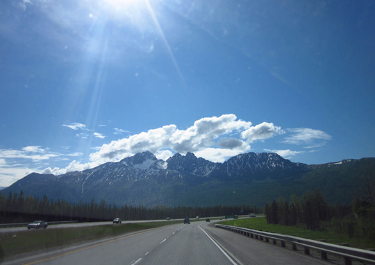
View of the
Chugach Mtns. going south on the Glenn Hwy. toward Anchorage.
The two
peaks that are close together to the right of the glacier are called
Twin Peaks.
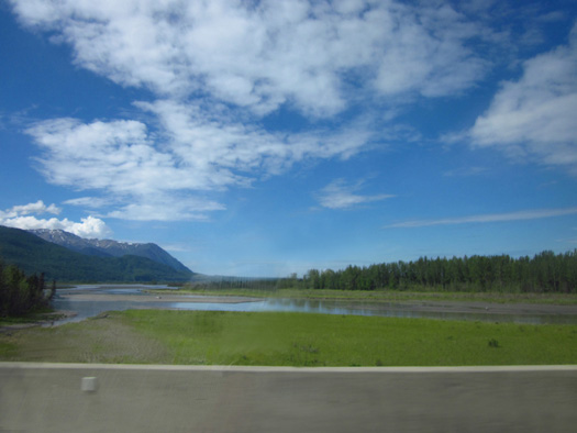
We crossed the very wide Matanuska River at MM 31.5 and the Knik River
a mile later. Each river has braided (multiple) channels as it
flows toward Knik Arm.
We'd been following the Matanuska River from its
source at the Matanuska Glacier. The Knik River comes down from the Knik
Glacier. We could see part of the Knik Glacier from the highway but I
didn't get a good picture of it.
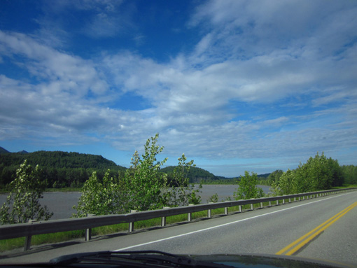
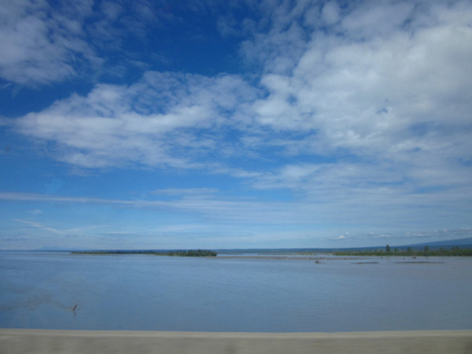
A large estuary, including the Palmer Hay Flats State Game Refuge, lies
at the end of Knik Arm:
I could see numerous birds as we drove through the wetlands. They
provide a major migratory route in the spring and fall and are the most
heavily-utilized waterfowl hunting area in Alaska. There are several
access sites to the estuary.
Moose winter in this area. The cows and calves can be seen in the early
morning and evening until early July. Then they head to higher, cooler
terrain nearby
until autumn.
We passed through the area about noon and didn't spot any moose. We know
they are there, though. At the intersection with the George Parks
Highway (goes north to Fairbanks) there was a sign that said 455 moose
had been killed by vehicles but I don’t know the time period and if it
was just in that area.
View of Knik Arm from one of the bridges on the
Glenn Hwy. north of Anchorage
The highway crosses a protected wildflower area called the Eklutna Flats
around MM 27. From the highway I could see some very pretty wild blue
irises that looked like the Japanese irises in our garden in Virginia.
There is a one-mile trail around Reflections Lake near MM 30 that I'd
like to explore while we're in the area.
Some of the same flowers we saw blooming in Valdez also bloom here in
June, including shooting stars, chocolate lilies, wild roses . . .
and dandelions, of course!
SO MUCH TO SEE AND DO!
The Eklutna area has
several places we'd like to visit sometime this summer, including
Eklutna Lake Recreation Area in the humongous Chugach State Park. We're
interested in several hiking and biking trails there. Thunderbird Falls
is nearby, as well as an historic park with an old Russian Orthodox
church and unique cemetery with colorful "spirit houses."
Those can be day
trips from Anchorage, since they are only half an hour from our
campground at JBER (off the Glenn Hwy. at MMs 25-26).
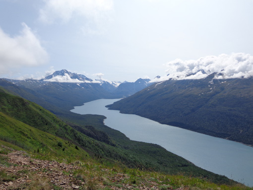
View of Eklutna Lake from the Twin Peaks Trail (I
cheated; since I'm uploading this
entry after the trip was over, I'm using this
picture from a hike later in the summer).
We passed
Eagle River (a river and community named after it) at approximately MM
13.
Like the
Matanuska and Knik rivers, the Eagle River is a glacial stream
originating in the Chugach Mountains northeast of Anchorage. A
once-rural area that was originally homesteaded after WWII, the town of
Eagle River is now a fast-growing residential and business area that is
almost a suburb of Anchorage now.
While we're
in the area I'd like to visit the Eagle River Nature Center and explore
some of the trails along and above the two branches of the river that
flow down into Knik Arm.
The most
famous trail in the area is the Crow Pass Trail which crosses the
Chugach Mountains for 24 miles from Girdwood to Eagle River. There may
be too much snow now to get to the pass but I'd like to hike part of the
trail out-and-back from the Eagle River end of it. A point-to-point foot
race is held on the trail annually in July but the time limit is too
strict for me to walk it (I'm not supposed to be running any more).
Around MM 11 we
could see a bike path next to the southwest-bound side of the freeway.
It kept going to (and past) our exit at MM 8.
I doubt we'll ride
there, though.
There are enough miles to ride at JBER and on other bike paths in the
city that should be more interesting than right along the freeway.
Anchorage probably has more miles of bike paths and trails than any
other U.S. city of its size.
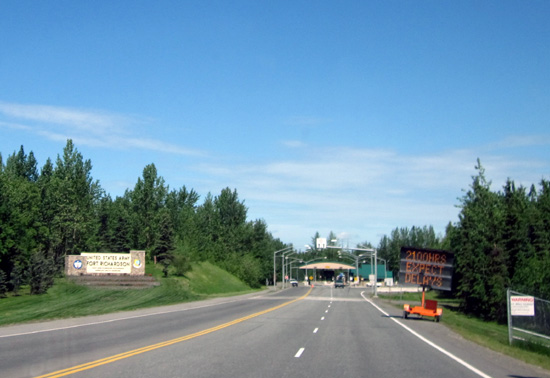
Approaching the Richardson Gate at JBER
The exit at MM 8 leads west into Fort
Richardson, home of the "Arctic Warriors." You don't have to be active
or retired military to enter the post but you do need a driver's
license, current vehicle registration or rental agreement, and proof of
insurance if you want to drive around on post or visit the National
Cemetery near that entrance.
This the the northernmost of several gates into
the sprawling Joint Base Elmendorf-Richardson (JBER).
To the east is a frontage road that connects to Arctic Valley Drive,
which is
accessed at MM 6 if you're going northbound on the Glenn Highway. Arctic
Valley Drive leads about seven miles up into Chugach State Park to a ski
area and lots of alpine trails. Hiking to Rendezvous Peak is one of my
objectives this week. The Milepost reports that the panoramic
views from the top are spectacular.
So many things to do in this area and I haven't
even begun to list what we'd like to do in the city proper while we're
here . . .
Next entry: getting settled in at the Black Spruce
Campground at JBER
Happy trails,
Sue
"Runtrails & Company" - Sue Norwood, Jim O'Neil,
and Cody the ultra Lab
Previous
Next
© 2012 Sue Norwood and Jim O'Neil
