Just how big is Wrangell-St. Elias? Denali National Park & Preserve, in the upper left corner of
this map section, contains more than six million acres of land. It's
almost three times the size of Yellowstone. That's
pretty big.
Now look
at Wrangell-St. Elias National Park & Preserve to the lower right:
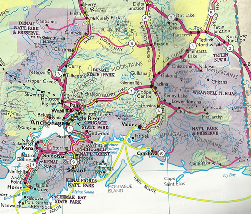
It contains a whopping 13.2 million acres, a land mass larger
than the states of Massachusetts, Connecticut, and Rhode Island
combined.
Heck, it's even bigger than the entire country of Switzerland.
This park's designated wilderness, at nearly 10 million acres,
represents about 10% of the entire national Wilderness Preservation
System.
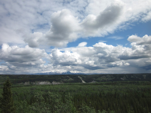
That's BIG. So are its mountains.
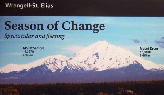
Two of the park's peaks that you
can see on a clear day from the main visitor center; I took this
photo from an interpretive panel
at the viewing area. "Live" photos are farther down this page.
Nine of the sixteen highest peaks in the U.S. are
located in this one park.
Four major mountain ranges meet in the park
-- the Wrangells, Chugach, St. Elias, and Alaska Ranges.
The park contains at least one active volcano, Mt. Wrangell, and some
inactive ones
Elevations within the park range from sea level at the Gulf of Alaska
to 18,008 feet on Mt. St. Elias, the second-highest peak in the U.S.
(Mt. McKinley in Denali NP is highest.) Ecological zones range from
boreal forests below 3,000 feet through sub-alpine and alpine zones to
the nival zone above 7,000 feet, where the snow and ice never melt.
Then there are the massive ice fields and hundreds of glaciers.
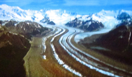
One of the hundreds of glaciers in Wrangell-St.
Elias NP; I took this photo
from the film we watched at the visitor center,
"Crown of the Continent."
Just one of the park's numerous glaciers, Malaspina, is larger than
the state of Rhode Island. (OK, so Rhode Island is a little state. But
that's big for a glacier!)
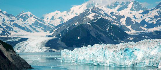
Nabesna Glacier is more than 75 miles long.
North America's largest sub-polar ice field, Bagley, is located near the
coast, spawning huge glaciers popular with visitors who can view them
from Inland Passage cruises or on flight-seeing tours.
One of those tidewater glaciers is the Hubbard Glacier. I took this photo from the park
website:
The cooling
effects of all this ice are felt through western Canada and down to the
Lower 48.
Wrangell-St. Elias is part of a World Heritage Site, one of the world's
largest internationally protected areas. A total of 24 million acres of
land include the adjacent Kluane National Park in the Yukon, the
Tatshenshini-Alsek Provincial Park in British Columbia, and Glacier Bay
National Park & Preserve in Alaska.
ALASKA IS FULL OF PUBLIC LANDS
Wrangell-St. Elias is one of
fifteen national parks, preserves,
monuments, and historical sites in Alaska. The state has a whopping 54
million acres in national parks and many more acres of public land in state parks and
national forests.
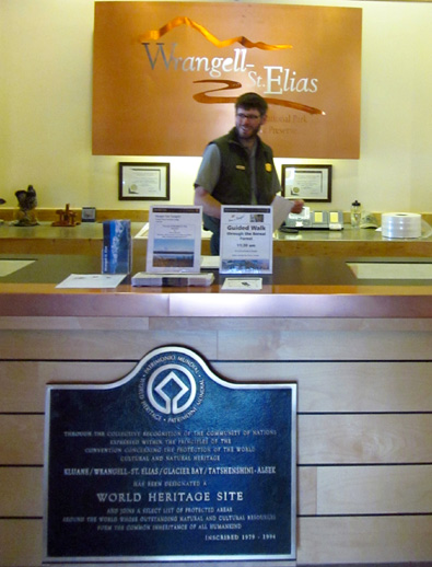
One of the rangers we met at the main visitor
center today
Preserving a diversity of plants and wildlife is one of the obvious
reasons so much land has been set aside in Alaska.
The idea that certain places are special, above the marketplace, and
worthy of lasting protection is uniquely American, first demonstrated
when Yellowstone became a national park in 1872. Alaska's first national
park was established in Sitka in 1910, almost half a century before it
even became a state.
Alaska's national parks also preserve thousands of years of human
history and culture, from early inhabitants who crossed the Bering
Land Bridge 14,000 years ago to the Gold Rush era in the late 1800s.
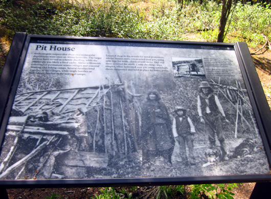
Site of a former Ahtna Athabascan
homestead along the Boreal Forest Trail at the visitor center
Many of the national parks in Alaska, including Wrangell-St. Elias,
were created in part to protect lands used traditionally by Native
Alaskans who are permitted to hunt, fish, and gather within these park
areas ("subsistence" fishing and hunting).
National preserves were established to allow for sport hunting and
trapping so other residents and visitors can engage in these pursuits.
TRAVEL LOGISTICS
You already know Alaska is immense. Its land mass (375 million acres)
is one-sixth the size of all of the Lower 48 states put together. Traveling by road
throughout the state is both limited and challenging.
Unlike most national parks in the continental U.S. you can't just
drive to most of the national parks, preserves, monuments, and
historical sites in Alaska.
According to the official National Parks
in Alaska brochure, "Experiencing Alaska's more remote treasures
can require significant time, effort, and money and may involve air or
boat charters, rafts, kayaks, and hiking."
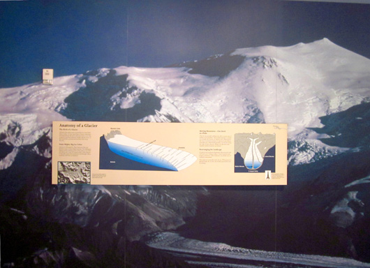
Part of the interpretive display
"Anatomy of a Glacier" at the main visitor center's exhibit hall
The good news is that two paved highways, the Richardson and the
Tok Cutoff, allow decent road access to Wrangell-St. Elias National
Park.
Two unpaved roads penetrate the park itself. They are remote and
rugged, but they do allow more access than many of the other national
park units in Alaska.
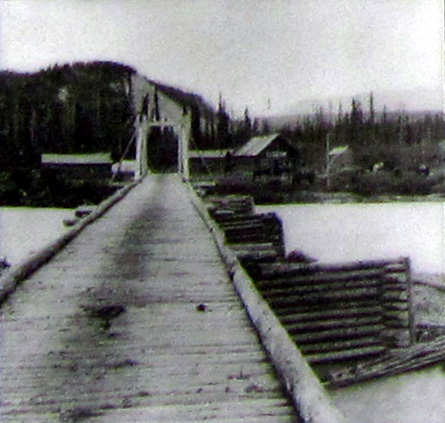
The McCarthy Road extends 61 miles from Chitina to the Kennicott
River, just west of McCarthy. It follows an old railroad bed. The road is not regularly maintained and
takes about three hours to drive (probably more with an RV). Visitors
can park at the river and cross it on a foot bridge to the former McCarthy
mill town and the historic Kennecott
Mines National Historic Landmark, the site of picturesque old copper
mining buildings and equipment.
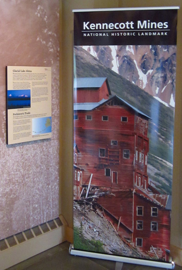
Photo of a unique Kennecott Mine
building from the
mining display at the main
visitor center's exhibit hall
The northern part of the park is accessed via the Nabesna Road off
the Tok Cutoff. It extends 45 miles from Slana to Nabesna, a privately
owned but inactive gold mining camp. Fewer people go into the park on
this road than the one to McCarthy.
CAMPING, LODGING, & SERVICES
Wrangell-St. Elias was established as a national park and preserve
rather recently -- 1980. It's one of the newest and
least-developed parks in the system.
The park brochure emphasizes that Wrangell-St. Elias is a park for
wilderness-oriented activities.
A display in the handsome exhibit hall
Not only is road access very limited, there are very few
accommodations and services. There are no campgrounds inside the park,
although backpackers can camp anywhere they want and they don't need a
permit. Visitors can explore the backcountry on their own or hire
private operators to guide them inside the park. The park manages
several public use cabins accessed by air.
Folks with less time and energy can find plenty to enjoy at the main visitor center
complex.
There are lots of campgrounds and pulloffs along the Tok Cutoff and
Richardson Hwy. where RVers can stay when they're visiting the park.
There are also motels, restaurants, and roadhouses offering tourist
services.
ACTIVITIES IN THE PARK
OK, so most people don't stay inside the park. In fact, most visitors
don't even get into the park very far. What's the draw??
Basically, you're on your own. If you're highly self-motivated and
self-sufficient, or have the money to hire a guide service, there are a
lot of physical activities to do in Wrangell-St. Elias National Park:
- Sightseeing
- Flightseeing
- Hiking
- Backpacking
- Horseback riding
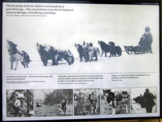
Historical images of Native
Alaskans and early explorers (display in kiosk near parking area)
- Dog sledding, still a popular way to explore the wilderness
- Fishing
- Hunting
- Wildlife and scenic photography
- Bird-watching
- Mountaineering
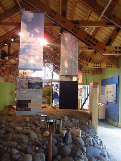
More interpretive displays in the
bright exhibit hall
- Ice climbing
- River rafting
- Kayaking along the coast
- Cross-country skiing
- Snowmobiling
Despite all the snow, ice, mountains, and rivers in the park many
species of plants and wildlife are adapted to the harsh conditions.
Caribou, moose, bison, bears, Dall sheep, and mountain goats live there. Salmon and
other fish spawn in the streams and lakes. The Copper River drainage is
a major flyway for migratory birds and provides nesting sites for
trumpeter swans. Coastal areas also provide habitat for marine mammals
and birds.
AN IMPRESSIVE VISITOR CENTER COMPLEX
We read a lot about this park before our visit to Alaska. I was
interested in seeing the unique buildings at the Kennecott Mine, which
other RVers had said was worth the long drive into the park to see.
Once we got to that part of the state and saw how much snow was still
on the ground, however, we decided to postpone a trip inside the park
until later in the summer or another summer entirely. We did what most
visitors to this park do -- enjoyed the park headquarters and
main visitor center complex near Copper Center and called it good.
Information kiosk near the
parking area
Note that there are several
other visitor centers and ranger
stations within the park, including one in McCarthy. We haven't been to
any of those.
You usually can’t beat a national park visitor center for the free
entertainment and education. (Many visitor centers are outside the fee
area.) I’ve been to a lot of them over the years; this is one of
my favorites. It gets very few visitors compared to more accessible
parks in the Lower 48.
Above and below: two photos from the 1920s in
the display about the early history of the
Richardson Highway, which runs from Fairbanks to Valdez
and past Wrangell-St. Elias

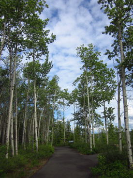
The short road to the main visitor center is located about three
miles north of Copper Center on the Richardson Highway near MM 107.
I was totally impressed with the handsome log buildings and the
setting among beautiful aspen, birch, and spruce trees, with views
toward several of the prominent peaks in the Wrangell Range.
It helped that we had near-perfect weather during our two-hour
mid-day visit, too.
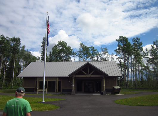
Jim approaches the exhibit hall
at the main visitor center.
There were very few vehicles in the large parking area when we
arrived at 11:30 this morning. We had no problems finding room for the
Cameo. More people came in during the two hours while we were there.
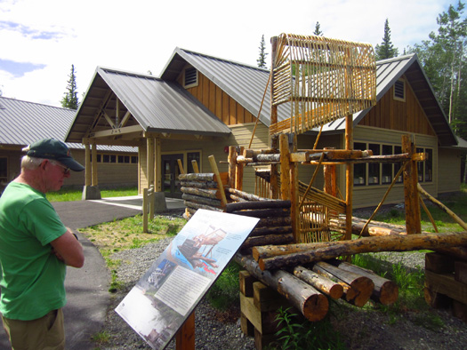
At least six handsome wooden structures built about ten years ago are
arranged in a large circle surrounded by a beautiful boreal forest.
After viewing historical photos and information at a kiosk
next to the parking area we walked over to the Ahtna Athabascan cultural
center to view the large “fish ladder” on the lawn:
Jim reads about the history and function of fish
wheels, which are still in use
today by Alaska Natives and other residents when
the salmon are running.
Unfortunately, the cultural center is open only on weekdays --
and this is Sunday.
The park visitor center and other buildings are open daily in the summer
(and weekdays in the winter) so we were able to enjoy all they have to
offer.
We looked inside the next building, the theater, to see how large it was
– plenty big for the number of vehicles in the parking lot, so we went
to the main building next to kill 30 minutes before the next film began
(on the hour).
The main building is built like a lodge but doesn’t offer rooms or have
a restaurant. It has an information desk, several helpful staff members
to answer questions and lead ranger talks, a book and gift store, a
scale model of the park, beautiful animal pelts, and lots of other
exhibits and information. A comfy couch sits in front of a fireplace.
It’s a very attractive, inviting space.

My, what big paws you have! Jim examines the
lethal claws of a grizzly bear on display.
The next building has even more exhibits about the history of the area –
cultural, mining, etc. The sixth structure holds restrooms.
The theater is very comfortable. We watched the 22-minute film about the
park, “Crown of the Continent,” with just four other visitors. It
has fantastic views of the park that most people will never see in
person. We felt like we were there. I took several pictures from the
screen and have used one of them near the beginning of this entry.
When we went outside a group of people were gathered around one of the
park rangers at a nearby overlook where we could see Mt. Drum, Mt.
Zanetti, and Mt. Wrangell in the distance:
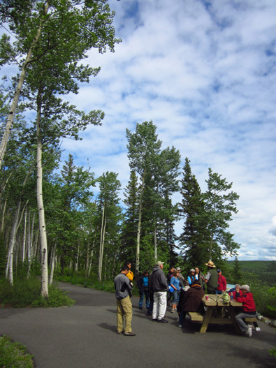
Jim had already gone back to the camper to make lunch so I didn’t stay
to listen. I took several pictures, then followed the paved and dirt
trail part way around the parking area.
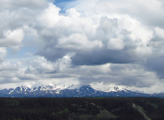
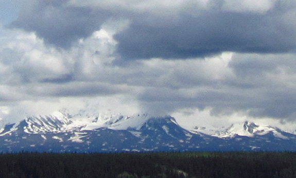
Closer and closer views toward Mt. Drum and other
nearby Wrangell peaks; the photo
below is the closest I can get with my basic
12-megapixel Canon A1200 camera.
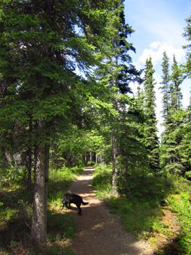
After eating lunch I talked Jim into hiking with Cody and me on the
half-mile boreal forest trail. That was very relaxing, a nice break from the
driving we did today. We didn’t see anyone else on this beautiful trail.
We found evidence
that bears live here:
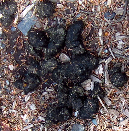
That's some real bear scat, not the
synthetic examples displayed in the visitor center. I showed a picture
of those samples in the last entry. The box displaying them says,
"Scat. Please touch and examine."
Bet kids have even more fun with that
than we did!
At 1,100 feet in
elevation the permafrost is far enough below the surface of the ground
that the forest surrounding the visitor center is full of willows and
other shrubs, wildflowers, and lots of aspen, paperbark birch, balsam poplar, alder,
white spruce, and black
spruce trees:
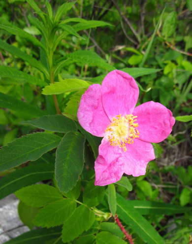
Prickly rose
Many mammals also live at the boreal forest elevation up to 3,000
feet. Above that, in the sub-alpine and alpine zones, fewer and fewer
plants and animals can survive approaching the 7,000-foot elevation
where the ice and snow never melt.
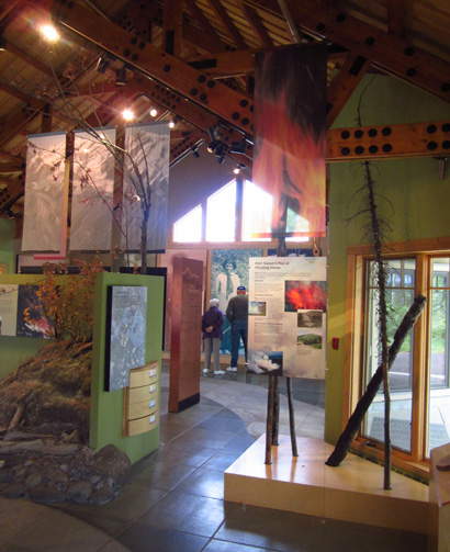
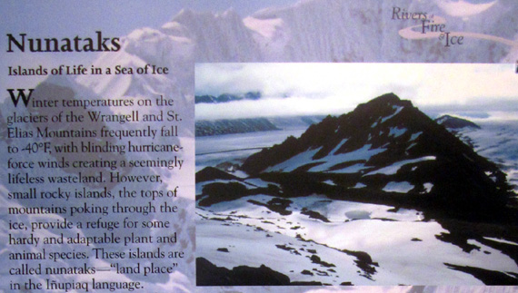
In the exhibit hall we learned a lot about glaciers and life --
or the lack thereof -- in the nival zone, a
permanently frozen world. I haven't heard of this zone before.
I took this photo of part of the exhibit about nunataks, the
peaks of mountains surrounded by glaciers:
We highly recommend travelers in the area stop at the visitor center
for an hour or more to learn about the park, even if they have no desire
to go any further into it. All the exhibits, film, and trail are free.
The historical, cultural, and environmental information is so
interesting, you'll be glad you took the time. What I learned just whet
my appetite to return another time to explore further into the park.
And be sure to catch the 22-minute film about the park. The scenes
are breath-taking. Obviously it's not the same as exploring the park in
person but you'll see
things in the movie that would otherwise require a bunch of $$$ and time for a plane ride
or guided tour.
Next entry: interesting buildings and equipment at
the outdoor historical museum in Alpine
Happy trails,
Sue
"Runtrails & Company" - Sue Norwood, Jim O'Neil,
and Cody the ultra Lab
Previous
Next
© 2012 Sue Norwood and Jim O'Neil
