Now that was a tough beginning on the route to the Klondike!
Our campground was close to Valdez Glacier, which is smaller now than
it was during the gold rush. Thousands of stampeders braved the slick
ice, avalanches, dangerous crevasses, snow-blindness, exhaustion, and other hazards
on their quest to find gold via the All-American Route to the interior
of Alaska.
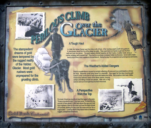
For some it took two months to haul their heavy gear eighteen miles
from sea level to 5,000 feet to the pass at the top of the glacier. They
had to move a year's worth of supplies by dog sled and on their backs
over five steep ice walls along the narrow, winding, crowded trail.
Along the way the prospectors set up temporary tent towns.
That was just the first eighteen miles of their journey to the
Klondike! They still had many more miles of rugged, unexplored Alaskan
wilderness to negotiate after that.
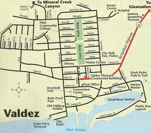
If you look at this map of the Valdez area courtesy of The
Milepost book you can see that there is still a large white glaciated area
north of Valdez:
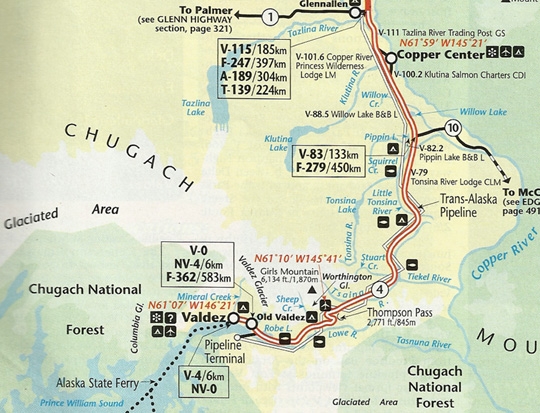
Points of interest = Trans-Alaska
Pipeline and Terminal, Worthington Glacier, Valdez Glacier,
Thompson Pass, and Old Town Valdez.
The green areas are public parks, forests, and preserves.
The dangerous gold trail over Valdez Glacier was later relocated through
Thompson Pass and developed into a much more sane dog sled and wagon road
called the Keystone Canyon Trail in the
early 1900s. The Richardson Highway was built on/near that wagon road
for automobile travel in the early 1920s, connecting Valdez to Fairbanks.
The discovery of copper in the Wrangell Mountains northeast of Valdez
brought further development to the area in the early 1900s. Note the place
names in the map above -- Copper River, Copper Center. Some
silver was also mined near Valdez.
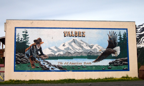
A large mural on a building in
Valdez commemorates the All American Route to the Klondike gold fields.
One of the
more interesting tourist attractions in the area is the old picturesque Kennicott
Copper Mine near McCarthy (just off to the east on the map above). We didn't visit the
mine on this trip because of the long
drive over rough roads through Wrangell-St. Elias National Park to reach it but
I'd like to see it someday.
A FASCINATING MIX
Valdez, a beautiful little seaport town with about 4,100 residents, was
our first real destination point in Alaska. We stayed for three nights
and got quite a bit done in the one afternoon and two full days we spent in the area.
If more rain hadn't been predicted, we would have stayed longer.
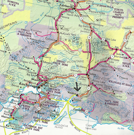
This map section from the official state highway map shows the
relationship of Valdez (below arrow I drew) to other popular tourist destinations in South
Central Alaska:
The setting is simply stunning, especially when the sun is out.
Situated in a deep blue glacial fjord in the northern part of
huge Prince William Sound, the little port town is surrounded by an
estuary, water, and the
5,000-foot-high Chugach Mountains, which have some snow on them year-round:
We were surprised, however, to find more than a little snow at sea
level in the middle of June.
At the visitor center we learned that Valdez averages more snow than
any other sea-level town in the world. The average is 325 inches of snow
each winter; this past winter they got 489 inches. Yikes!
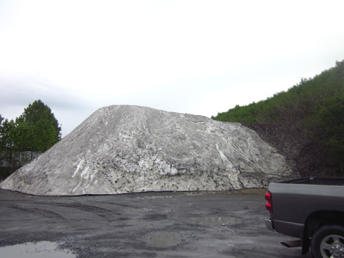
Even in
mid-June there is still snow on the ground in town in shady places at
sea level and large, dirty piles of snow in vacant lots and parking
areas where it was dumped to clear the streets:
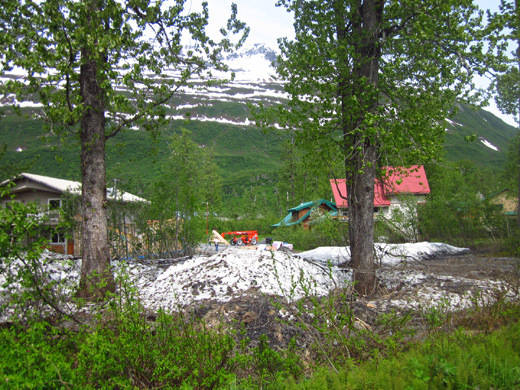
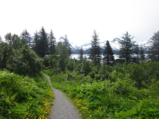
Fortunately all the bright green grasses and leaves and colorful
flowers look like spring-time. You should see all the dandelions! We're
definitely in our Dandelion Time Warp in Alaska.
Imagine how bright it was along the bike path and Richardson Hwy.
when all these dandelions were still blooming a few days ago:
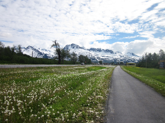
Now they're just dandelion puffs, waiting for the wind and
rain to spread their seeds so even more dandelions will come up next
year.
Valdez is the northernmost temperate rain forest climate on this
continent. In addition to all the snow, the town also receives an
average of 64 inches of rain each summer so it's very lush by mid-June even after a
harsher-than-normal winter:
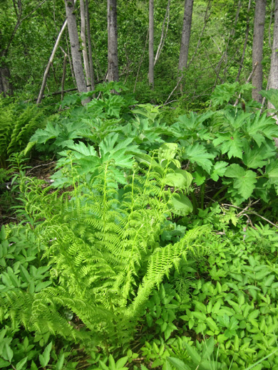
Thick rainforest growth along the
bike path (above) and
Dock Point Trail (below) looks
almost tropical.
We enjoyed Valdez even though it was overcast and/or rainy more than
sunny the short time we were there. You can see from the photos that we
did have some sun.
It was raining lightly when we arrived on Thursday
afternoon. Jim jokingly asked the woman at the
visitor center when the sun comes out and she replied, "This is about
as good as it gets!"
I have to admit that clouds often enhance scenery rather than detract
from it:
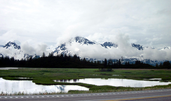
View across Duck Flats from the
Richardson Hwy. at the NE end of town
Don't let the prospect of either snow or rain deter you from visiting
Valdez. Despite the chilly, damp climate we had a good time there and wish we'd stayed longer.
We managed to ride our bikes two days, do some hiking, walk all over
the harbor and campground, drive to some interesting spots, and do some
indoor activities. I'll cover all that on several pages so I can show
you lots of pictures.
WELCOME TO THE NEW VALDEZ
Although it is no longer a port of entry for gold and copper seekers the town
remains an important gateway to Interior Alaska. It offers the shortest
link, via the Richardson Highway, to much of the state for cargo
arriving by ship -- and for tourists traveling by ferry or
wheeled vehicles.
Valdez is 304 highway miles from Anchorage (115 air miles) and 366
highway miles from Fairbanks.
If you're traveling in an RV allow plenty time for a trip to either city
to or from Valdez because of road conditions and all the interesting things to
see along the way.
View from the harbor area to the
mountains "behind" the town
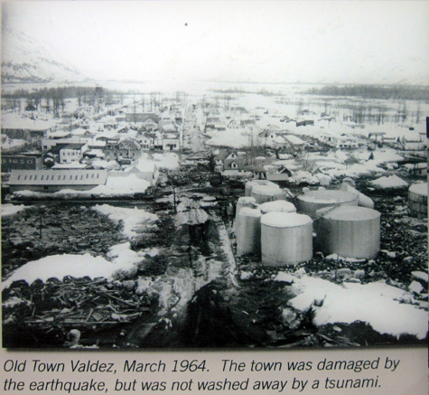
Several other significant historical events since the gold rush have
shaped life in Valdez -- the five-minute, 9.2-magnitude Good
Friday earthquake in 1964 that forced the town to relocate four miles
south to its present location (and played havoc with several other
Alaskan towns), the construction of the Trans-Alaska (AKA Alyeska) Pipeline and Marine
Terminal in the 1970s, and the Exxon Valdez oil spill in 1989,
which also occurred on a Good Friday.
I'll talk more about the earthquake in a bit and show some photos of
the original town site.
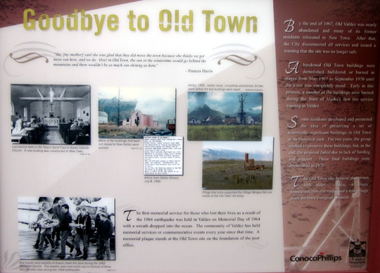
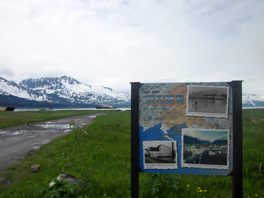
One of several panels of information displayed on
the wall outside the Old Valdez Museum
Copper and gold mining play a more minor economic role now in Valdez
than the oil, fishing, and tourist industries do.
Construction of the Alyeska Pipeline was completed in 1977. It runs
800 miles from Prudhoe Bay in northern Alaska to the marine terminal in
Valdez Harbor, where it is loaded into tanks or tanker ships.
We could
see the pipeline in various places along the Richardson Hwy. as we were
driving south to Valdez earlier this week but we really had to look for
it. It's not an eyesore on this stretch of highway (don't know about
farther north).
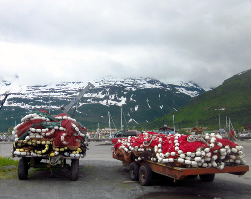
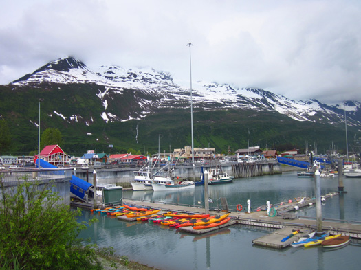
Colorful fishing nets along South
Harbor Drive
Both commercial and recreational fishing and boating are big
businesses in Valdez, especially during the brief summer season. Many
residents earn a living fishing or taking visitors out on sport fishing trips
in Prince William Sound and the Gulf of Alaska.
We enjoyed seeing the fishing boats and fish processing centers
around town:
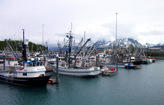
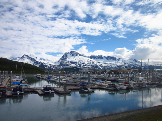
Leisure craft also fill the small boat harbor.
Many Alaska residents have their own recreational craft and this is
one of their favorite playgrounds. Prince William Sound is as
gorgeous as it is huge. The scenery from the water is awesome,
especially when there's as much snow in the surrounding mountains as
there is this June:
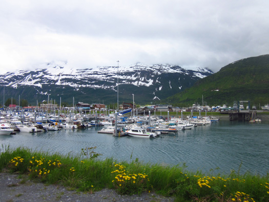
Another view across the harbor to
the mountains "behind" Valdez
Although we didn't go out on a boat trip from Valdez we enjoyed the
views of the Sound from several vantage points.
We walked and rode our bikes along the paths and streets
close to the ferry terminal, dock, and small boat harbor. We also had
great views of the harbor and water from the overlook trail above the
convention center and the ridge trail at Dock Point Trail:
This is another map from The Milepost book.
We got a different perspective of the port, harbor, town, and
mountains on the northwest edge of town from South Harbor Drive (shown
above) and Dayville Rd. (off this map) where the Solomon Gulch Fish
Hatchery and pipeline terminal are located.
I'll show more harbor photos on another page in this series.
OLD TOWN VALDEZ
The unprecedented 1964 earthquake destroyed the original town, which
was located four miles east of the current town. The 9.2 quake was
centered in Prince William Sound. Massive underwater landslides caused
tsunami waves that killed 33 people on the wharf. Seismic earth waves
also wreaked havoc on residences and downtown.
This is one of the old photos of the town that is on display outside the
Old Town Museum:
So much damage occurred and the ground remained so unstable that the
Army Corps of Engineers determined the whole town must be relocated.
Within four years all the residents had moved to the new town.
Only 52 buildings from Old Town Valdez were able to be salvaged and
moved to the new site.
This is why you don't see many historical buildings constructed
before the mid-1960s in Valdez. Most of the newer homes and businesses
are simple and functional. This is one of the more upscale neighborhoods I saw
in town:
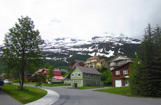
I rode through there on my bike to check out the Mineral Creek trails.
The advantage of relocating the entire town was being able to plan it
in a less haphazard manner than most towns and cities evolve over time.
We drove out to the site of the original town. There are no
buildings, just interpretive signs and the cement slabs where some
buildings used to stand.
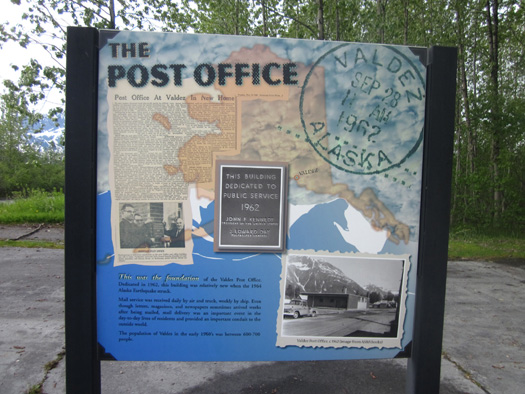
This was the location of the Post Office:
We read enough information and saw enough photos of the original town
and the quake/tsunami destruction that we didn't go inside the Remembering
Old Valdez Exhibit in the Valdez Museum annex:
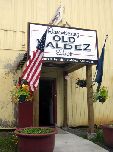
Some of the information is displayed on the wall to the
left of the entrance, above, and more interpretive panels are at the
original town site.
The description of the
detailed scale model of the town before it was destroyed sounds very
interesting, as do the other exhibits, so I'd like to go into the museum
if we ever return to Valdez. We just didn't have time to do everything
on our list in two days.
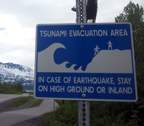
Despite my knowledge of this history it was still a bit of a surprise
to see tsunami warning signs along the streets and roads in and near
Valdez:
The other signs that were interesting were the numbers mounted
several feet above all the fire hydrants -- so they can be
located during the winter when the town gets massive amounts of snow. We saw numbers as high as the 400s. That's a bunch of hydrants.
Next entry: dozens of year-round activities to enjoy in
Valdez
Happy trails,
Sue
"Runtrails & Company" - Sue Norwood, Jim O'Neil,
and Cody the ultra Lab
Previous
Next
© 2012 Sue Norwood and Jim O'Neil
