Continued from the previous page.
NOT QUITE YET
By Friday afternoon
we knew the initial optimistic reports about the road reopening at
Canyon Creek were premature.
We went over to the visitor center several times that day to see when
we'd be able to leave:
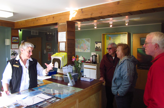
Edie, a friendly staffer at the visitor center,
explains for the umpteenth time that the road isn't open yet.
The first couple days after the road closure the visitor center was
designated as the location for people to get updates about progress.
The staff at the visitor center soon became overwhelmed giving out
second-hand information received from the highway department, however,
and government officials came up with a new plan during the weekend.
A LONG WEEKEND
By Saturday we knew were weren't going anywhere anytime soon. This
report and a small version of the next photo appeared on the CBC website that day:
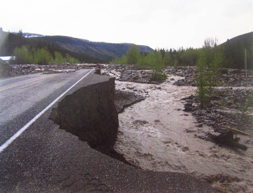
Caption: Repairing the damage to the Alaska Highway near Rancheria,
between
Teslin and the junction of Highway 37 [the Cassiar], may take
days, according
to Yukon's Department of Highways and Public Works.
(YDHPW photo)
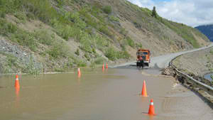
This is the washout that was closest to us. That photo shows
only part of the damage.
The visitor center had a larger version of the same photo used on the
CBC website. I took a
picture of it with my camera. I zoomed in to the far side of the road and cropped the
photo below to show a little more clearly that a large chunk of roadway
in the distance completely washed out by Saturday:
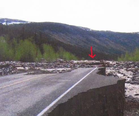
It was no longer mudslides that were preventing everyone from moving,
it was this big washout.
When the volume of water receded sufficiently crews hauled in enough
rock and dirt to build a ramp to connect with this half-remaining
roadway.
One-way traffic drove on the ramp and this piece of pavement last
night and today. In the next entry I'll show you a picture of what the ramp looked
like when we crossed this creek this morning.
The plan is to build a temporary detour completely around this
"pioneer road" after the bottle-necked traffic gets through, so crews
can properly repair the highway without having to deal with vehicles on
it.
It'll be interesting to see it in the fall when we come back through
here. Even if we drive down the Cassiar Hwy. we'll have to go over
Canyon Creek first.
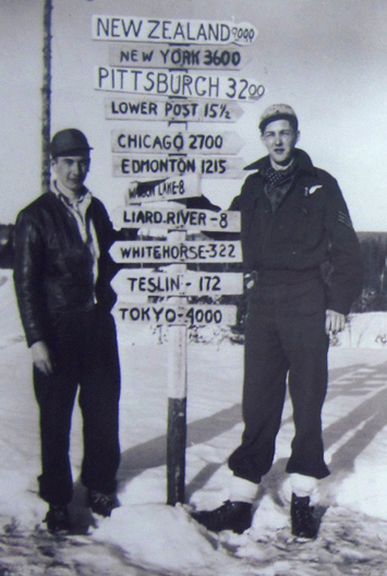
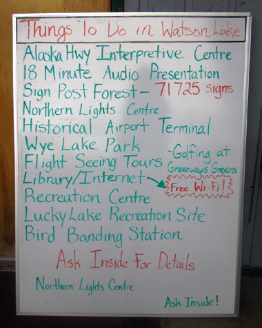
This sign, erected by the U.S.
Army Corps of Engineers in Watson Lake
in 1942 during the construction
of the Alaska Hwy., is the only original one
like it remaining. It became the
nucleus for today's popular Signpost Forest.
By Sunday the EMS building across the highway became the official
control center for the highway department, RCMP (Royal Canadian Mounted
Police), and rescue personnel who were coordinating the evacuation of
local flooded communities.
Radio broadcasts were made from there to keep residents and travelers
from the east and south informed about the closures.
We could also go to that location for verbal information and
assistance, such as the use of land line telephones to make free calls.
Many cell phones, including ours, don't work in the Yukon.
One of the advantages of our campground was having free WiFi
intermittently. The signal was weak and we couldn't always get online
when we wanted but we could occasionally read reports about the road progress.
Since our Verizon cell phones didn't work in the Yukon we
couldn't get online with our personal MiFi card even if we had wanted to pay the
exorbitant out-of-country fee to use it.
Here's another photo from Sunday's online CBC
article:
Caption: Part of
the highway on the Alaska-Yukon border seen here was washed out Friday.
Crews are still working to clear many highways in the territory.
(photo by Matthew Carpenter)
MAKING THE BEST OF IT
When we realized we'd be in town longer than expected we tried to
maintain our sanity by getting more exercise than we do when we're
driving most of the day.
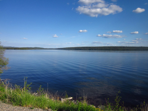
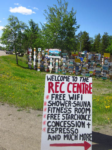
My three-mile hike to and around Wye Lake with Cody became a morning ritual for me.
Sometimes I did it twice. It was calming. I wandered through the signpost forest coming and going
to the lake,
finding new and interesting signs each day.
Been there, done that. Now what?? Sign posted
at the door
of the visitor center on Thursday, our first day in
Watson Lake.
Jim ranged farther and farther from the campground on his bike each day.
He had plenty of dirt and paved roads to ride.
I joined him on the Alaska and Campbell Highways one time but usually
just rode my bike to the other end of town and back to see how many more
vehicles got stacked up each day:
The access roads on either side of the AK Hwy. looked like tailgate
parties as folks
walked around or set up chairs and made new friends!
Watson Lake was an important supply and launching point during the
original construction of the Alaska Highway in 1942. There are
interpretive signs in town and at the airport several miles north on the
Campbell Hwy. that explain this history.
One day Jim drove up to the
airport and took some photos:
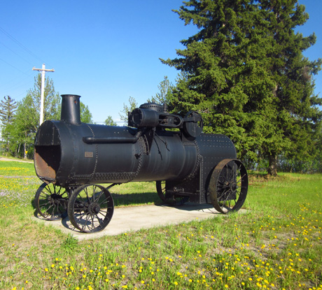
This is a stationary steam engine that was used to
build the airport in 1940.
The lake named Watson Lake is near the airport, several miles
north of the town of Watson Lake:
The weather was nice during most of our stay – partly to mostly sunny,
no wind, low 60s each day. It was great to have sunshine after so much
rain.
We were concerned, however, because more rain is forecast for this week.
That doesn't bode well for the reconstruction of the road ahead of us.
CONTROLLED RELEASE
Each morning we'd wake up and wonder if this was the day we could
proceed.
Estimates by officials in Watson Lake on Sunday night were for the road to
reopen Monday morning, maybe. Then another delay occurred;
the pioneer roadbed wasn't stable enough for all the traffic it would be
receiving and it had to be reinforced.
Everyone continued
to wait through the day on Monday.
An example of Yukon hospitality that many visitors
sincerely appreciated
By then we were mostly resigned to the situation. What will be, will
be. We ignored rumors floating around that the road might not open until
Wednesday and concentrated on one day at a time.
Monday we spent yet another day periodically checking websites and the
communications center for updates on the road, taking walks, riding our
bikes, chatting with friendly townspeople and fellow travelers, and
continually revising our plans for how long we'd stay at various places
in the Yukon.
By this time we just wanted to get through it as quickly as possible.
We were itching to get to Alaska.
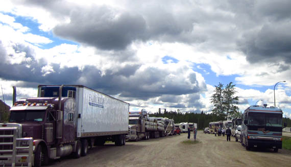
We knew from radio updates and personnel at the command center that
the glut of vehicles in Watson Lake would be allowed to leave town in a
"controlled release" when the pioneer road over Canyon Creek was deemed
safe to drive. There were dozens of semis waiting, at least 250 RVs, and who
knows how many passenger vehicles in Watson Lake alone.
Jim and I had some discussions about what that might mean for us.
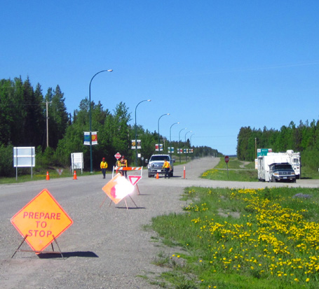
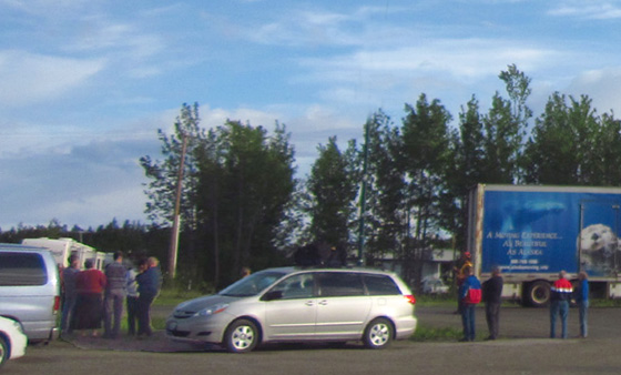
The roadblock on Sunday. The
Tempo gas station and Tags convenience store
and RV Park where we stayed are
to the right, out of the photo. Note the camper
hovering near the roadblock; most
folks tried to get up as close as possible.
We knew that the semi trucks would be the first to leave. That was
good, because we wanted them in front of us -- they drive faster
than most RVs on the Alaska Hwy. -- and unloading the supplies
we needed in Whitehorse several hours up the road.
Next were folks who really, truly needed to get out of town -- those
living in their vehicles without a place to sleep and/or money to eat
every meal out, folks who were either working when they got delayed or had to get
back to their jobs, people with
plane or cruise reservations they hadn't already missed, vacationers with limited time,
RVers who'd been boondocking and/or were running out of food, and
others.
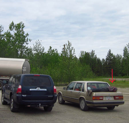
Early one morning I cycled past a
young man sleeping on the trunk of his car. I don't know
if he was there all night. A semi
hauling fuel tanks and other vehicles were parked nearby.
Last on the list were retired RVers like us who had a home on wheels,
enough supplies, and a bigger cushion of time.
Officials diplomatically asked the public to honestly determine which
priority group they belonged to and police themselves accordingly. They
didn't want everyone to rush for the exit at once.
We didn't want that, either. We were concerned about a long convoy of
RVs and other vehicles all leaving town at the same time, creating
continued problems with traffic and finding campsites, food, and fuel
all the way to the Alaskan border and beyond.
Fortunately, it didn't turn out that way and we practically had the
road to ourselves for over 250 miles when we finally left Watson Lake.
THEY'RE MOVING!!!!
A grove of trees separated our camper from the roadblock at the west
end of town. I could just barely see the highway from my desk window in the
camper. All of a sudden at 7:45 PM on Monday (last evening) I
heard a commotion and saw that trucks
were heading west!
Yay!!!
That was a good sign, although the general public wasn't allowed to
go (only emergencies) until all the trucks were out of town and safely
over Canyon Creek 75+ miles away.
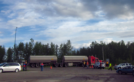
Yes, we want those tanker trucks
moving toward Whitehorse!
This was one of the first trucks moving through the
roadblock.
We could have easily made up some story about why we absolutely had
to get out of Dodge but we played fair. Besides, it was to our advantage
to wait until the stores and gas stations were re-supplied in Whitehorse
before we got there, about a 285-mile drive.
I went out to the roadblock with a big smile on my face and watched
as a long line of semis tooted their horns as each passed the guys directing
traffic. In addition to fuel trucks, refrigerated trucks, and a variety
of trucks hauling other items I saw a moving van (next photo) and a tour
bus full of people. I have no idea where they stayed while stuck in
Watson Lake.
The scene at the roadblock and all over town was like a street party. People were laughing, high-fiving,
and running to tell others the good news.
Happy travelers watch as a long
convoy of trucks leaves Watson Lake last night. The blue one is
a moving van. Some folks up the road will also be
happy to finally get their household goods!
The relief among everyone was palpable, visitors and
townspeople alike. The road guards were pretty happy, too, because their
job was almost over.
RVers were encouraged to spend the night and tune in to the official
radio station this morning
to be sure it was safe to proceed. If the pioneer road crumbled under
the weight of the trucks, we were screwed.
Jim and I got the camper mostly ready
to go so we could leave quickly if we had the opportunity this morning. When we went to bed at 10:30 PM there
wasn't any more news yet about a general public release of vehicles from
Watson Lake.
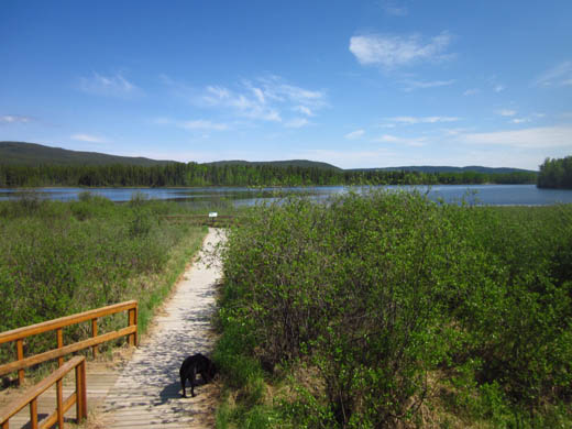
One of the trailheads at Wye Lake
begins on boardwalks through wetlands.
We talked some more about ways to avoid having to jockey for position
getting out of Watson Lake, then being in a big caravan of RVs
and other passenger vehicles heading up the road. Not only were there
several hundred such vehicles sitting in Watson Lake waiting for the
signal, there were also others on the way there from farther south on
the Alaska Highway and still more coming up
the Cassiar Highway that we'd intersect in a few miles.
Should we stay up and leave during the night if we could? No, we
aren't 35 any more; we need
our sleep.
Should we get up at 4 AM and get an early start while other people are
still asleep? Maybe.
We didn't set an alarm. Since it's light this far north for most of the night in
mid-June I've been waking up 'way too early without the
need for an alarm. We counted on that. Besides, I was too hyper to sleep much anyway.
I was also tired enough from all the excitement that I didn't wake up
until 5:30 this morning, later than I wanted to. I woke Jim up. He was able to get online and
see an official update from 1 AM that said the trucks made it over the pioneer
road OK and it was safe for everyone else to travel now.
Yay again!!
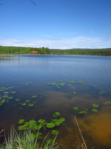
Lily pads float on Wye Lake.
That sounds like kind of a sneaky "controlled release" but I don't
think it was intentional. The highway department was more than motivated
to get all those trucks out of town as soon as they could. Letting the
trucks go through the night made sense because truckers are more used to driving all night than the general public.
By midnight the semis should all have been past the pioneer road and
engineers who assessed it knew it was safe for the rest of us to cross.
I'm glad they considered the roadbed issue thoroughly and took adequate
time to ensure everyone's safety.
The controlled release at night did seem to spread out the glut of
vehicles so they didn't bottle-neck too badly anywhere last night or
today.
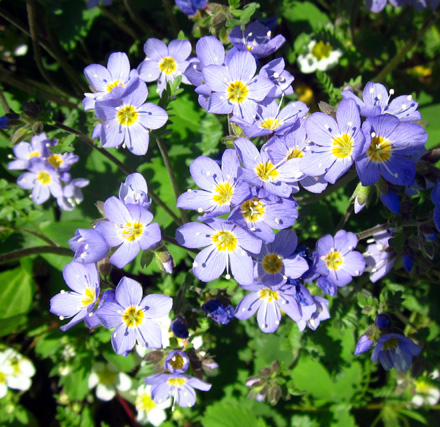
Pretty Jacob's Ladder is common in boreal forests in the
Yukon.
We set a record this morning getting ready to go. Only two other RVs
in our campground left before we did. We got out of town by 6:15
AM and practically had the road to ourselves until we got close to Whitehorse.
We also beat the milk, but that's another story (see next entry).
IN RETROSPECT
Looking back on this incident we know that although we were inconvenienced by the road closure, things could have
been much worse.
- If we'd been further up the road we could have literally gotten stuck in one of
several mudslides.
- We could have been swept off the highway at Canyon
Creek or another washout when the road simply vanished. Some travelers
witnessed that but didn't get swept away.
- We could have been stranded in a remote spot
between a mudslide and washout, unable to reach any services and
without a phone signal (we have both a CB and ham radio for such an
emergency). That also happened to a few travelers.
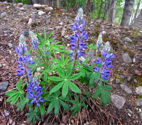
Robust alpine lupines at Wye
Lake; glad we were safe and had diversions like this.
Any number of other unsafe or uncomfortable things could have
happened to us. We were pretty lucky, all things considered.
In the entries about the rest of our trip through the Yukon I'll show
photos of some of the mudslides and washed-out areas and describe the
scene in Whitehorse. We got past Whitehorse today and are spending the
night in a beautiful provincial campground on the shores of Kluane Lake.
Cody and I just walked past a big pile of bear poop on a trail next to
the lake!
We hope to reach Alaska tomorrow.
Next entry: more photos from Wye Lake's boreal forest and marshes
Happy trails,
Sue
"Runtrails & Company" - Sue Norwood, Jim O'Neil,
and Cody the ultra Lab
Previous
Next
© 2012 Sue Norwood and Jim O'Neil
