Of all the things on our list of things we
wanted to do at Denali National Park, taking a flight tour over The High
One (the Native Alaskan meaning of "Denali") was at or near the top of
our priorities.
Flights are expensive (about $349-$449 per
person this summer) and since the mountain is more often shrouded in clouds than
not, we waited until yesterday to reserve our seats, hoping that the
good weather forecast would hold out.
If the weather isn't conducive to safe flying
over the Alaska Range, the air companies don't fly. In addition, we
wanted to get good, clear views of Denali, not partial ones obscured by
clouds or rain.

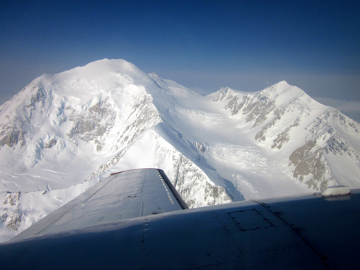
I think this
is the east buttress on Denali; only a few clouds remained
when we got
close to the south and north peaks on our flightseeing trip today.
We woke up to mostly cloudy skies and only a little bit of sun at Riley
Creek Campground just inside the entrance to the park.
We remained optimistic, however. Although we had no clue re: the weather at
20,320-foot Denali, which is about 75 miles south of the campground, Fly
Denali was on top of it (so to speak) and our flight was a "go."
Another sneak peek at Denali's north and south
peaks from the air . . . I believe this is the south buttress.
I mentioned in the first of yesterday's entries that we got a good
discount on our tickets through a reference from CJ, our campground
host. The rate we got for RVers is 15% off the regular price, better
than the 10% military discount we also qualified for. Fly Denali has
other
discounts, too, so check them out
before booking a flight to see if you qualify for one. And check with
other companies to compare features and costs.
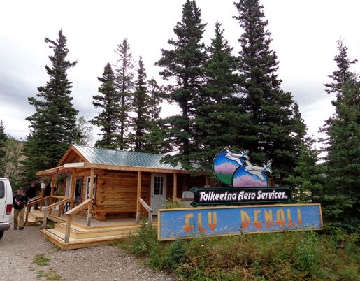
The air company we chose appears to go by two names: McKinley
Flight Tours and Fly Denali, Inc. The phone numbers are the same. Since
the website
is Fly Denali I'll stick with that.
JIM AS "CO-PILOT:"
THAT'S MY BIRTHDAY PRESENT!
This morning we drove north a few miles to a private RV park where the
air company van picked us up. Five other people in their 60s and 70s
were already in the van. They are staying at a lodge in Nenana Canyon
outside the park entrance.
The driver took us a few more miles to the little airport in the town of
Healy, where Fly Denali begins their flights. They also fly out of
Talkeetna.
When he called to
make reservations yesterday, Jim asked if he could sit next to the
pilot. The woman booking the reservation said no one else had asked, so
he could have that seat upon the pilot's approval.
Jim was a little
pessimistic that would actually happen, so when we
signed in this morning at the airport he asked again about sitting next
to the pilot. That was OK with Trent, our young pilot. He's on the left
in the next photo:
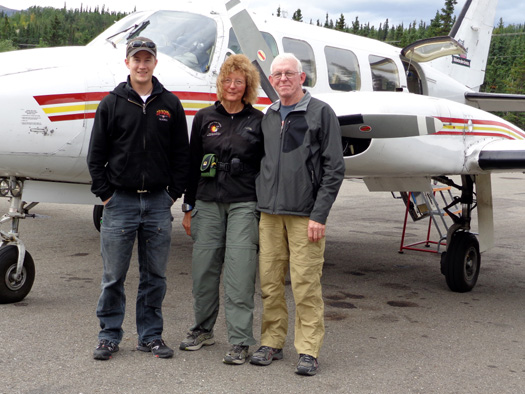
Seat assignments were by weight and sort of how we checked in. Jim and I
were first in line. I was seated behind the pilot and a man by himself
was in the seat on the other side of the aisle. The three couples were
seated across from each other. In these small planes,
everyone has a window seat.
Jim was beaming as we
got settled into our seats:
While we could still hear each other talk,
he commented that being up front was his "birthday present." I mentioned
in the August 1 entry about how we do (or don't) celebrate
birthdays as we age. Gifts are a rarity because we usually jut get what
we want, within reason, when we want it and then say, "That'll be my
birthday/Christmas/etc. present."
Jim and I were sitting close enough together that we could swap cameras
easily. Whoever was on the side with the best views at the time used the
16-megapixel Sony compact digital camera. We used the 12-megapixel Canon
compact digital for less important pictures.
Most of the photos on our website are ones I've taken. In this case, we
don't remember who took what pictures from the plane. I just chose the
ones shown in this entry as the best representation of the various
things we saw today. Jim probably took as many of them as I did.
LET'S FLY!
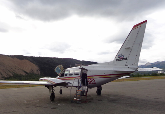
The Piper Navajo Chieftain low-wing plane we boarded holds nine
passengers but it flew today with just us seven. We boarded front to
back, so Jim and I were the first ones on.
Once we were on board Trent explained how to use the head phones, which
we wore the whole trip so we could hear him above the noise of the
engines, and the oxygen masks, which we used only between 13,000-21,000
feet.
The plane is un-pressurized. Trent said there is three times less oxygen
at 21,000 feet than at sea level. Supplemental oxygen isn’t a necessity
for these trips but he explained that we’d all be a lot more comfortable
using it. No one on our flight got sick and no one had any trouble
breathing or with their ears coming back down.
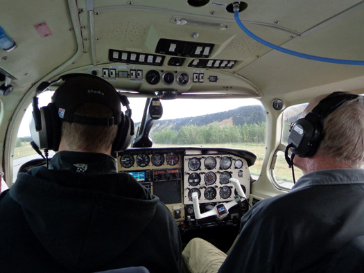
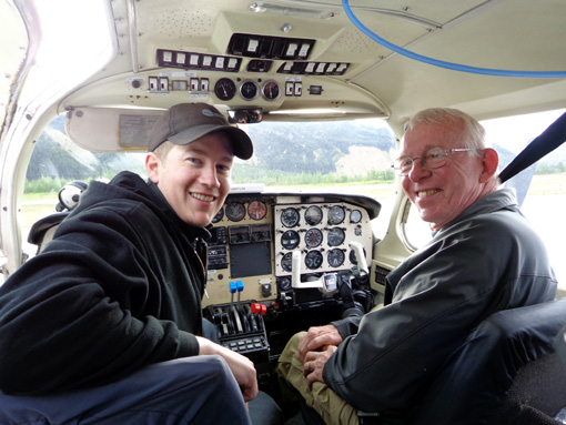
Trent (L) and Jim with their headphones on as we get ready to take off
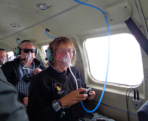
Sue with oxygen mask on, somewhere above 13,000
feet
I forgot to turn on my Garmin GPS until we were over the park entrance,
about ten miles from the airport in Healy. My GPS recorded 274+ miles so
we did a total of about 285 miles in the plane.
Altitudes on my GPS ranged from 1,279 feet on the ground to 20,713 feet
at Denali. Jim says the plane’s altimeter was about 200 feet lower than
that at the mountain. He had fun reading the gauges, since they were
right in front of him. I couldn’t see all of the gauges but I had fun
watching my GPS.
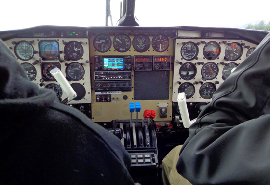
Sue's view of the gauges
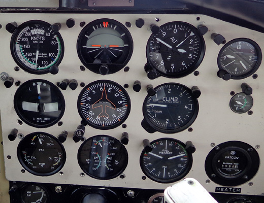
Jim's view of the gauges
We flew over the Nenana River through Nenana Canyon between Mt. Healy
and the mountains on the east side of the river:
Nenana Canyon left of the river, national park
property (and our campground) on the right
It was interesting to see this perspective of the ridge where I was hiking yesterday on the
east side of Mt. Healy:
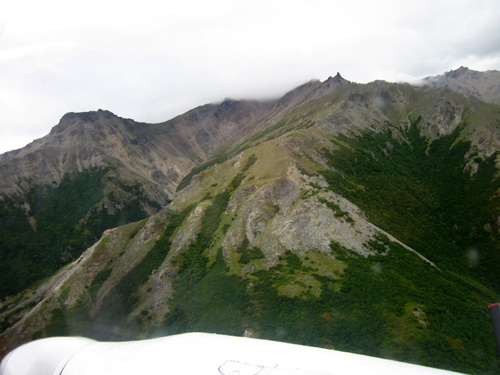
Many of these photos show the wing and/or engines
at the bottom so I can include more of the scene.
As Trent swung around the south side of Mt. Healy and began heading west
over the interior park road I could see the trail
where I walked on the ridge, although it doesn't show in this small
picture:
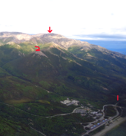
1 = Taiga Trail trailhead to Mt. Healy Overlook
Trail (visitor center, Murie Science Center,
and other front country buildings in lower right); 2=
the overlook; arrow = summit of Mt. Healy
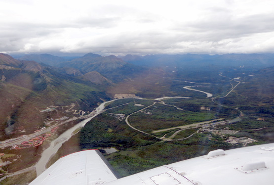
Two or three miles west we flew over the park headquarters (white
buildings below) and sled dog kennels (below arrow):
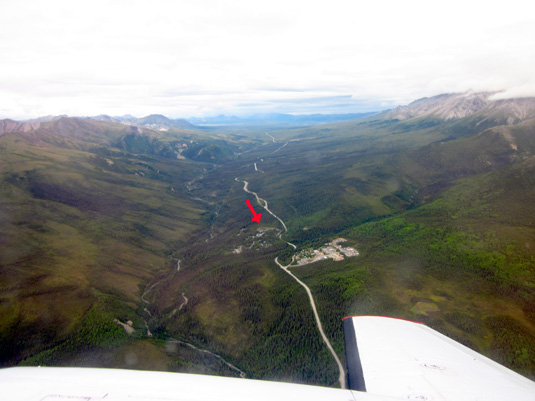
The park road continues west through the center of
this photo. A lot of this I could
see yesterday from the ridge to Mt. Healy but this
was a different perspective.
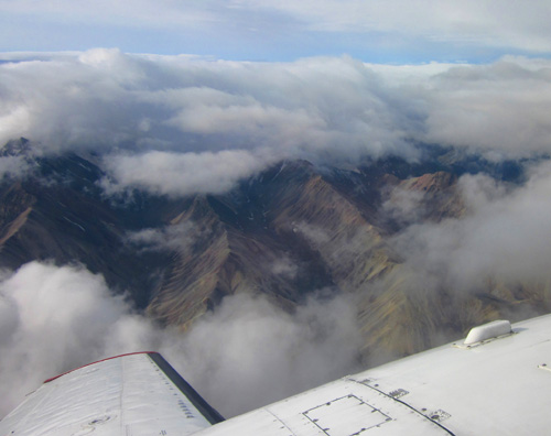
Trent flew above the park road far enough that we could see the
richly-colored hills between Sable Mountain and the aptly-named
Polychrome Mountain near the Toklat River:
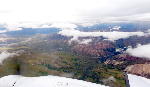
Good views at this low altitude even with some low
clouds
We won't be able to see all this from the bus. Some
things can be seen only by air or on foot.
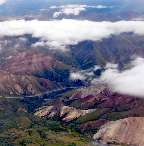
The narrow park road winds high above the Toklat
River near Polychrome Pass.
Can't wait to see this area along the park road close up on our first bus tour
later this week!
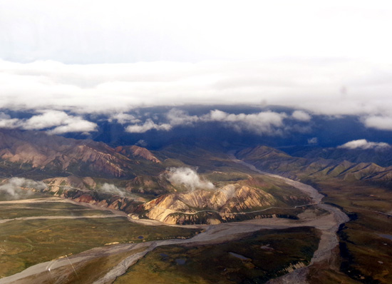
As he flew along
Trent explained what we were seeing – the park road, Polychrome Pass,
various rock features in the mountains, where the mountain goats and
Dall sheep usually hang out, various named glaciers, names
of mountains, etc. He tilted the wings so passengers on each side of the
plane could see better and take pictures.
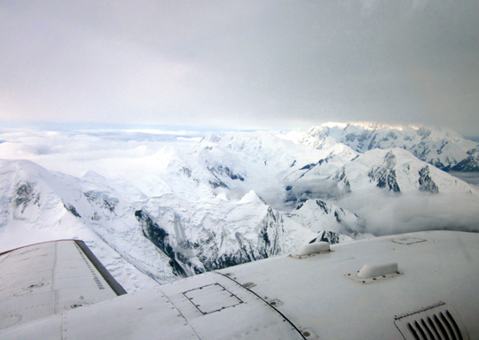
About 60 miles into the park Trent began heading mostly south over the
Alaska Range to Denali, the showcase mountain in the park -- and North
America!
We passed through a layer of thicker clouds. When we got
above them we were in a world of snowy peaks and sunny blue sky:
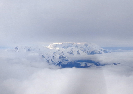
We could hear the radio traffic from ground control and other Fly Denali
planes as we were heading to Denali. Other pilots who arrived before we
did were reporting enough holes in the clouds to see the north and south
peaks clearly.
When we got our first
views of Denali we could see part of the northern slope but the north
and south peaks were still obscured by clouds:
There were enough holes in the clouds to see the vast Muldrow Glacier
that flows for miles like a river of ice on the north side of Denali:
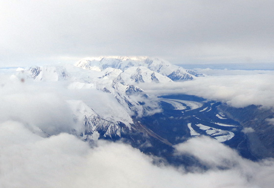
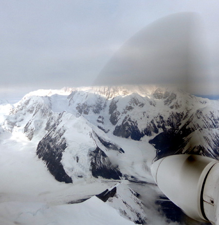
The dark hazy half circle is the moving propeller
of the plane; more glaciers below it.
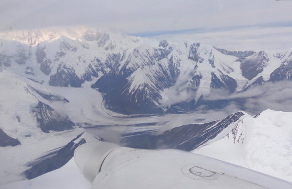
Intersection of either
the Taleikna or Brooks Glacier with the Muldow Glacier on Denali's north
side
We lucked out. Denali was even more in the sun when we got close to
it! We got our wish to see the mountain peak nearly free of clouds!!
Photos continued on
the next page . . .
Happy trails,
Sue
"Runtrails & Company" - Sue Norwood, Jim O'Neil,
and Cody the ultra Lab
Previous
Next
© 2012 Sue Norwood and Jim O'Neil
