Jim has a way with words, doesn't he? That barely-veiled criticism immediately cracked me up and made me
less tense in the passenger seat!
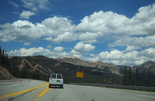
Oh, my. Have you ever driven this gorgeous 23-mile stretch of US 550
between Silverton and Ouray?? The paved highway cuts through the heart of the
San Juan Mountain Range with steep, snow-covered peaks, deep gulches, and
high-elevation passes. There are several 15-MPH switchbacks near Red Mountain and only a couple
places you can get over 45 MPH in a passenger vehicle -- if you
aren't following an RV or semi, which normally has to drive even slower.
The scenery is awesome. The road itself is awesome, too, a real
engineering feat. Do a web search for "Million Dollar Highway Ouray Silverton"
and you'll see what I mean.
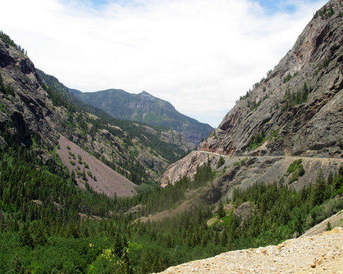
A portion of the Million Dollar Highway south of
Ouray; I took that photo in 2007.
It's also nerve-wracking if you're in the passenger seat on the outside
lane on the curves of this narrow, winding highway . . . just
inches from the edge of the pavement . . . where there are no
guardrails or even a shoulder because erosion has eaten away the cliff
. . .
Oh, and did I mention there is sometimes a yawning chasm several hundred, sometimes maybe even a
thousand, feet down into the canyons???
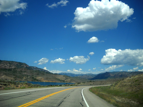
Here's a 2010 photo I showed you in my June 22 entry, when we were going south
from
Ouray to Silverton on this road:
The arrow points to an unguarded edge that drops right off from the
pavement.
This
link will take you to a more graphic photo on
the
Wikipedia site
that shows the narrow edge of the road through the Uncompahgre Gorge
better than any of the photos I've taken.
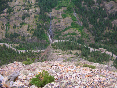
Here's a different perspective of the road, looking down. I took it
from the Bear Creek Trail during one of our Hardrock workdays in 2007:
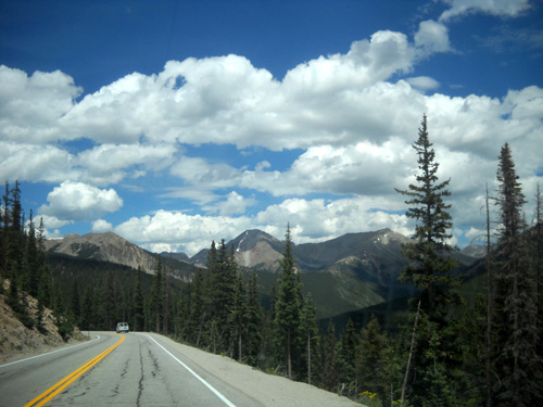
Fortunately, it's not as bad driving or riding northbound from Silverton to Ouray on US 550, as we did this morning.
We were on the inside lane for the scariest part a few miles south of Ouray and
I was next to solid rock walls.
That doesn't bother me as much as being next to
the drop-offs going south. But there was enough of the cliff-hanging farther south near
Silverton at the beginning of our journey this morning to make me hyper-alert
-- and more of a "back-seat driver" than I usually am!
I don't think I'm a control freak, but I do admit to enough
back-seat driving (from the front passenger seat) that sometimes
Jim comes up with a zinger like the one above to remind me who's
behind the wheel. At least we got a good laugh out of it and I
tried to relax a little more.
Nice. Even. Breaths.
As dramatic as I make this sound,
I've never needed a tranquilizer or other calming substance on
this or any other mountain road. I'm not usually afraid of
heights. This road is different, however, and it is almost as
nerve-wracking to me when I'm driving as it is when I'm the
passenger.
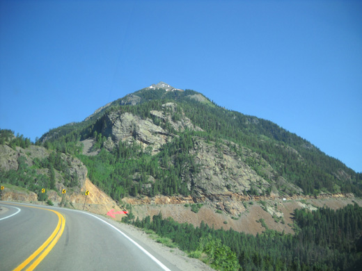
Red Mountain, near the 15 MPH switchbacks
Soon we were through Ouray, headed to Montrose, and on
straighter, more undulating territory north of the San Juan
Mountain Range. Ahhh. OK, now I can unclench my fingers and separate the WalMart
list into two pages so we can get out of the store twice as fast
. . .
TRAVEL NOTES: SILVERTON TO KENOSHA PASS
It is with mixed feelings that we left Silverton this morning.
We love it there but three weeks is about enough time in any one
spot before we get itchy feet and want to move on. Besides, most
of our running buddies left town on Sunday or Monday after the
Hardrock race wrapped up. Socializing with them is one of the
main reasons we go to Silverton.
We'll miss friends we may not see again for
several weeks or months.
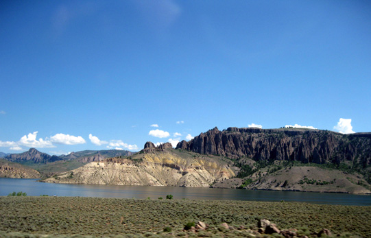
A view of Blue Mesa Reservoir going
eastbound on US 50 east of Montrose
But it's on to another race now. Jim's running the inaugural
North Fork 50-miler this Saturday in Pine, CO. Our choices for
camping nearby are seriously limited so we're going to stay at a
forest service campground at Kenosha Pass that we've used
several times previously. It's a 45-minute drive to the race
start/finish but it has its charms: low cost, great
scenery, cool temperatures at 10,000 feet, and access to trailheads for two segments of the Colorado Trail that I really like
-- almost right out our door!
When we left our campground near Silverton this morning a little
after 8 AM it was sunny and 48° F.
at 9,500 feet elevation. By the time we reached Montrose, sixty
miles north and 3,700 feet lower, it was already 87° F. there!
That was a shock to our systems after being in much cooler
weather the past three weeks.
A shot of the reservoir I took from the
truck in 2007, going west.
After stocking up on supplies and food at WalMart, filling the
tank with diesel fuel that was 46˘
per gallon cheaper than in Silverton or Ouray (!!), and eating
lunch, the rest of our 263-mile trek was scenic and pleasant in
our air-conditioned truck. We knew Kenosha Pass, at 10,000 feet
and farther north than Silverton, might be even cooler than
Silverton has been.
That's fine with us. We love the
cooler temperatures (but not too cold).
Here's our route:
-
US 550
north from Silverton to Montrose (9,500 → 5,800 feet)
-
US 50 east past the Black
Canyon of the Gunnison, huge Blue Mesa Reservoir, and Monarch
Pass (11,312 feet elevation, a snap with our Dodge Ram 2500)
-
US
24/285 north from Poncha Springs to Buena Vista (7,965 feet)
-
US 285 northeast to Kenosha Pass
(10,000 feet)
This is a fine route for both
passenger touring and RV travel. It is about as scenic as you
can get, the roads are in great shape, and we made good time on
this weekday despite some road construction here and there. It's
also a good route from the San Juan Mountain playgrounds to Denver, another hour
east of Kenosha Pass on US 285.
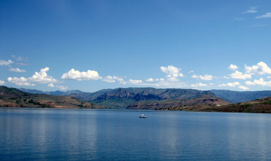
A boat on Blue Mesa Reservoir (another 2007
shot)
There were lots of campers and
boats enjoying the warm, sunny day at Blue Mesa Reservoir. We saw two Cameos on the roads
today, which is fun since there aren't as many of them out there
as some other brands of fivers.
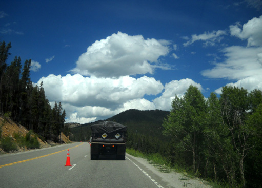
Following a dump truck through a
construction zone west of Monarch Pass on US 50
Along the way I decided I want to
return to Poncha Springs for one or two nights if we go back
down to Silverton in late August for Rodger's new fixed-time
race on Kendall Mountain. Crossing the Colorado Trail on
US 50 between Mt. Shavano and Marshall Pass reminded me of how
much I enjoyed Segment 15 when I ran/hiked it northbound in June, 2007
-- well, except for post-holing through the snow below the pass.
I'd like to do it again when there is no snow and go the other
direction so I'm going up to the pass and not coming down from
it (easier on my knees to hike up than down).
Above and below: there's a 6% grade
for 10 miles on the east side of Monarch Pass
When we reached Buena Vista it was a little odd to
head east instead of remaining on US 24 to go north to Leadville. Sometimes when we consciously have
to make a turn somewhere we joke about our vehicle being
programmed to go the usual route. Ha!
We'll probably get to Leadville
this summer but we've got other cool plans first. And we just might decide not
to go there this year. A lot of this trip we're making up as we
go.
CHILLIN' OUT AT KENOSHA PASS
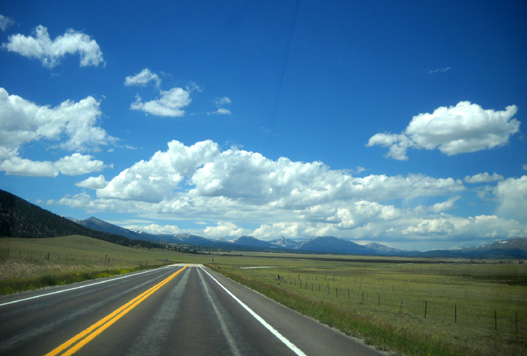
We love driving the scenic section of US 285 between Buena Vista and
Kenosha Pass through the huge South Park valley. The valley is
bounded by the San Isabel NF and a mountain range on the west
and the Pike NF and more mountains on the east.
We've gone westbound on this section of 285 more often than
eastbound, so it almost seemed like new territory going the
direction we went today.
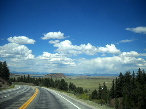
Even though South Park is in Colorado and not Montana, it's
definitely Big Sky country.
The ranches are huge, too. We saw one for sale that is 2,600
acres, then another that's 4,000 acres. That's a big chunk of
dirt to call your own!
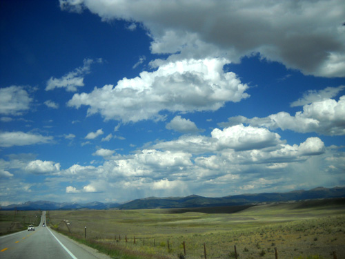
US 285 is a very busy road and it gets worse from Kenosha Pass to
Denver. Been there, done that. The western portion we drove today wasn't as frenetic as
we expect later this week when we check out the North Fork
course east of the pass.
As we approached the pass, we saw our friend Bill H's RV at an
overlook and knew he was already in the vicinity; he's
also running the North Fork race. He can park his compact RV in camping areas
closer to the course (and towns) but he knew we'd be coming to
Kenosha Pass soon and wanted to run some of the trails and dirt
roads near the pass while we were here. It'll be fun to spend
more time with him.
KENOSHA EAST CAMPGROUND
High on Kenosha Pass are large parking areas on both sides of
the road. On a summer weekend, they are full of vehicles whose
occupants are out enjoying the Colorado Trail (CT) but on this
weekday afternoon there were only a few cars, trucks, and RVs
parked there. We turned right (east) onto a narrow gravel road
and kept our fingers crossed that our favorite campsite would be
available.
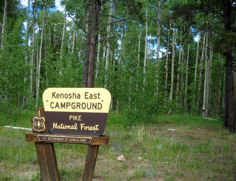
We know from camping here several previous times that there are only a few sites large enough for our rig in one of
the two National Forest Service campgrounds at this location. No
one can make reservations in the Kenosha East campground;
it is first-come,
first-served. We figured we'd better get here early in the week
so we'd maximize our chances of getting our favorite site.
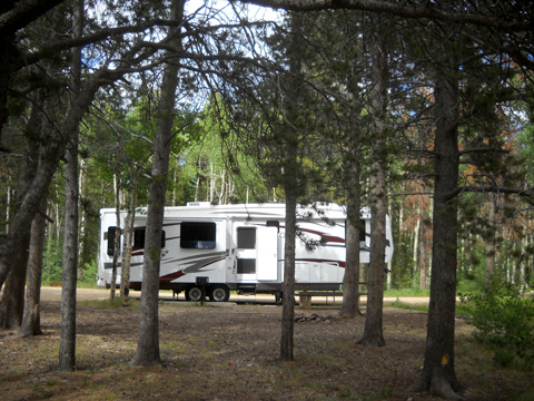
And we did. There were only two other campsites taken in this
campground when we arrived. Yes!
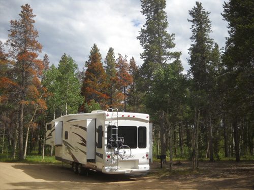
Jim has to drive around the tight loop at the far end of the
campground to approach this site with the door toward the woods.
Then he can swing into this space and maneuver forward and back
a little bit to get the Cameo straightened out.
Although vehicles drive by fairly closely on the
"street side" (left side in picture above), there is an abundance of
space on the other three sides:
Like just about everywhere else, there are some advantages and
disadvantages to this campground.
On the plus side, it is fairly inexpensive: $12/night for
most folks, half price if you have a National Park Service
Senior Pass -- which we'll have in two weeks when Jim
turns 62. The sites
are well spaced out and nicely shaded. The campground has
three clean pit toilets. It is adjacent to the trailheads
between CT
Segments 5 and 6; we literally run out the door to hit the trail
a couple hundred feet away.
And for history buffs, there's lots of interesting information
to read about Kenosha and Georgia Passes on interpretive
displays. I wrote about the history in an
entry when I ran the CT in
2006.
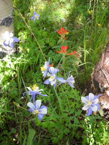
Blue columbines and
red Indian paintbrush near the campground on Seg. 5
The downsides include no nearby stores or services, no Verizon
cell service for our phones or computers, no TV reception, no
hook-ups, no dump station, and not even any water spigots in the
east campground.
As paid customers we can haul water from the campground on the
other side of the road, which is guarded by a vigilant CG host.
Our campground has no on-site host; the guy across the
road comes over a couple times a day to say hi and check on things.
I don't know how often NFS rangers come by.
For internet service, we can drive about 3/10ths of a mile down
the northwest side of the pass (toward Fairplay) to the overlook
where Bill's RV was parked and get online with our phone. For
WiFi, fuel, and stores, we have to drive about twenty miles in
either direction to Fairplay or Conifer.
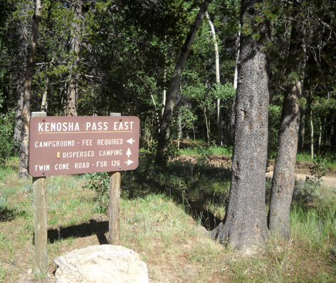
There are quite a few free dispersed camping sites farther back
on the east side of the road (see sign above) but we haven't wanted to haul our
5th wheel up or down either narrow, somewhat-rutted road (FSR 126 or
126A) to reach
them. We intend to explore farther back both roads while we're
here because we may return here for one or more nights if we head
to Leadville.
Folks who camp in one of the free areas aren't permitted to get
water in the west campground, a serious downside if we want to
stay for more than four or five days. We plan to be in our
current paid site for five or six nights.
ENJOYING THE HUMMERS
Not the kind you drive, the ones that fly!
One of the first things we did after getting settled in was to
make new "bird juice" and set up the hummingbird feeder as we've
done before at this site.
It didn't take long to attract some hummers, but I've discovered
it's more difficult to take photos of them through the
more-tinted Cameo windows than the less-tinted HitchHiker ones
in previous years. These are a few of my best shots:
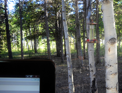
My computer monitor is on the left; feeder
is outside the window, upper right.
There are at least three and maybe four
birds feeding in that shot (can't see the far side).
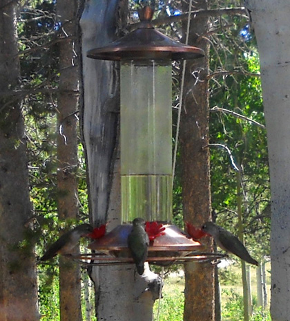
Another shot with at least three birds
feeding at once
We were surprised both by how fast the birds found the feeder -- and
by how
many would peacefully feed at once.
Often one hummingbird will ward off the
others while it's drinking but we had up to four at a time perched on the ring or
hovering just above the little "flowers" where they
sipped the
homemade nectar. We couldn't see four at once but as the feeder
twirled around we could see there were indeed four of 'em on
there sometimes.
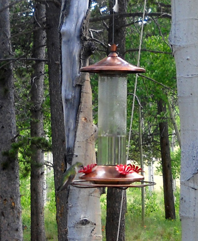
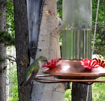
Above: a little hungry bird; close-up
below.
Talk about distracting! Watching hummingbirds is even more
addictive than watching who's coming and going in the campground
(fortunately, not much of that here). We had to refill the
feeder with more liquid after several hours, the fastest ever.
They're gonna keep us busy.
CHILLIN'?
So guess how chilly it was at Kenosha Pass this afternoon . .
.
Unfortunately, it wasn't anywhere near chilly. It was
close to 80° F. at 10,000 feet!!
Colorado is predicted to have quite a heat wave this week,
with mile-high Denver getting up to and over 100° F.
Guess I'll quit whining about how
hot it is at Kenosha Pass!
After a relaxing afternoon and evening we're looking forward to
running and hiking on Colorado Trail Segment 5 tomorrow. I'll
feature it in the next entry.
Happy trails,
Sue
"Runtrails & Company" - Sue Norwood, Jim O'Neil,
and Cody the Ultra Lab
Previous
Next
© 2010 Sue Norwood and Jim O'Neil
