After participating in this race two years ago, we can vouch for all of the
above!
It's definitely mountainous, the running surfaces are varied, the views are awesome, and
it is family and crew friendly. It's also one of the best organized
ultra marathon races in which we've ever participated. Check my journal entries
from September,
2007
and you'll see what a great time we had here
before.
We had fun this week running on various parts of the course.
Each 25-mile "loop" consists of three smaller "loops" of varying
distances and terrain. This entry will feature photos from just
about every mile of the course. I've divided it into two parts
because I wanted to include lots of photos. There are more
photos on our
Picasa site.
PREVIEWING THE COURSE
Jim's run all of the GTR course previously but couldn't remember
all of it. The course description sounds very confusing just
reading it; it's not as confusing during the race,
however, because it's so well marked and you know where to go on
the second and subsequent loops. In addition, race personnel are
pretty diligent about making sure runners go out on the correct
loop each time they come into the main aid station at the center
of the "cloverleaf." This is especially critical at night in the
100-miler as runners' brains turn to mush.
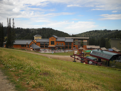
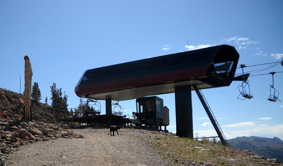
"Base" area at Grand Targhee Resort; the
Dreamcatcher chairlift is on the right.
The main aid station, at the center of the
cloverleaf, will be near the green canopy. (9-1-09)
Jim is signed up for the 50-miler this time. He considers this race a training run
as he ramps up for the Bear 100 in three weeks.
Although he needed to do a bit of tapering this week before running the
50-miler tomorrow, he wanted to get in more miles than he would
if he was peaking at GTR. He's done three familiarization training runs on
the course this week, running all but the paved road portions.
I saw very little of the course two years ago because I was
recovering from a knee injury. I've been very curious to
see what everything looks like -- the road up to Fred's
Mountain, the Mill Creek Trail, Rick's Basin.
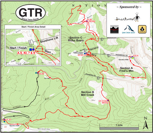
Red and black lines = one 25-mile segment in the 50- and 100-mile
race courses; repeat as needed.
Now that I've
either run or driven all but two miles of the course, I
know what I'm in for if I ever decide to run the marathon or
50-miler!
I'm (wisely) serving as crew again this year, and not
entered in any of the four race distances: 100 miles, 50
miles, marathon, or the new 10K that was added this year. After my bike
wreck and minimal training the past month, I'm glad I wasn't
signed up for GTR because it would have been more struggle than
fun.
Neither of us has any desire to do the 100-miler here. Four
loops on this course are tough for anyone, especially folks our
age, despite the generous 36-hour time limit. There are almost
20,000 feet of elevation gain and 20,000 feet of loss in the
100-miler.
Here's the course
profile from the website. It
doesn't look as steep as some profiles because this is only 25
miles of the course; it isn't scrunched up from side to
side like it would be if 100 miles were portrayed in the same
space (in other words, this profile is more realistic than some
others I've shown in this journal over the years):
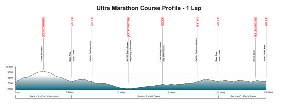
It's still a significant elevation gain and loss, especially at
altitudes of 7,000 to 10,000 feet.
Jim has concluded that two loops in the 50-miler are challenge enough.
After his second arduous climb to the top of Fred's Mountain
tomorrow,
he'll be relieved to know that he doesn't have to go back up
there again. It was during his third grunt up the
mountain in 2007 that he called it quits in the 100-miler.
After I climbed to the summit of Fred's Mountain on Tuesday and ran/hiked
back down to Targhee Base, I decided even ONCE was too much for me! Going up
isn't my problem; it's the long descent
for anyone with knee problems as serious as mine. The other two loops don't have as
much elevation gain and loss. They wear on runners in other
ways, though.
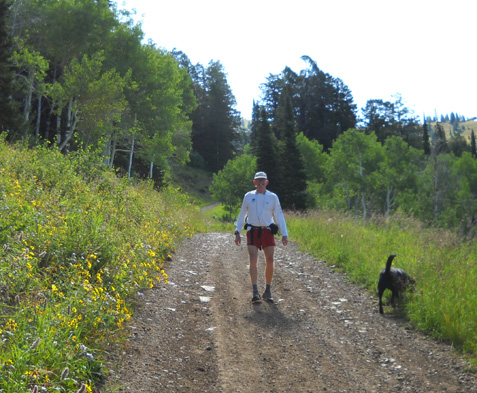
Jim turns around for a picture as we begin
the climb
up Fred's Mountain; soon he was out of sight.
I'll describe each of the three loops in the order in which they
are run during the race and show you photos
I took this week. The course is as beautiful as it is challenging;
that's one reason why the number of entrants increases each year.
Note that at this time of year there were no sources of water
along the course to refill water bottles or let Cody get a
drink. We had to carry all of our water. On race day it'll be no
problem, as there are aid stations and water drops every 3-4
miles.
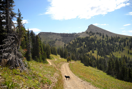
SECTION A: FRED'S MOUNTAIN (0 - 5.6 miles)
For each section description, refer to the map above. More
details about the
course are on the race website.
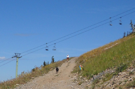
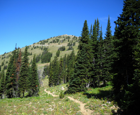
The first loop starts at the Grand Targhee Resort base area
(elev. ~ 8,000 feet), just below the Dreamcatcher chairlift, and
follows a rocky dirt service road, officially known as the Teton Vista
Traverse Trail, to the top of Fred's Mountain (elev. ~ 10,000
feet). Runners check in at at Aid Station #1 and head back down
the road to the base area, crossing under the Dreamcatcher lift
before reaching the Base Aid Station. It's almost an exact
out-and-back, but not quite. Jim's GPS measured this loop at 5.8
miles, a little longer than the official distance.
Most of the climb to the summit of Fred's is fairly gradual,
with at least a couple plateaus and dips where I could
comfortably run:
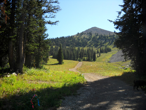
There are some steep grades on this road, however, as well as loose rocks
and dirt that weren't as much of a problem for me going up as
they were coming back down. I slid around some on the descent. I
should have worn my grippy-soled Montrail Highlines that day
instead of my Asics 2130 trail shoes.
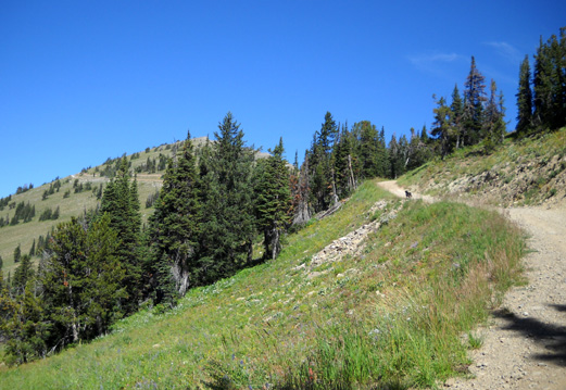
Pretty flowers, scampering marmots, and awesome views helped
distract me from the uphill grind, though.
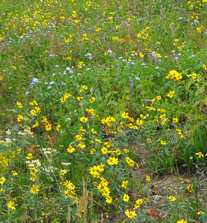
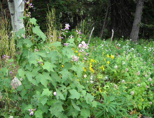
I saw a couple of new kinds of flowers I haven't seen anywhere
else in the mountains this summer, and MORE DANDELIONS! I can't
believe we're still in the "Dandelion Time Warp" after nine
months of traveling this year!
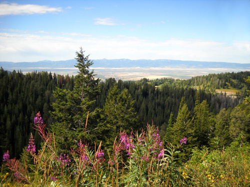
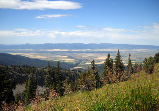
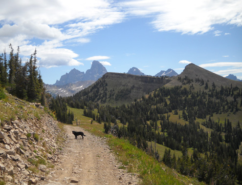
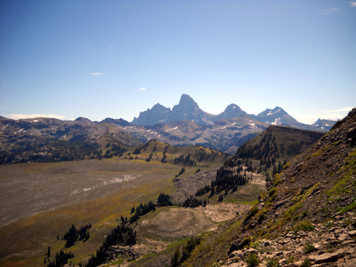
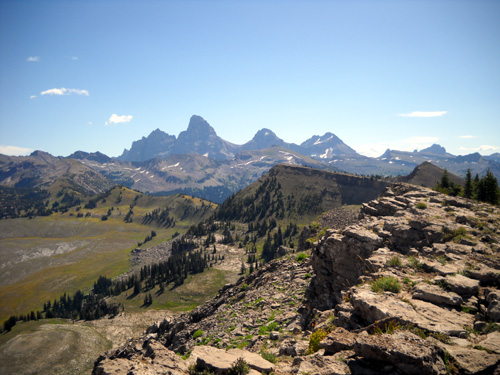
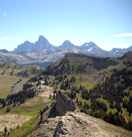
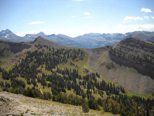
The views are simply awesome going up and down this mountain,
and they become more expansive the higher up you go:
the distinctive shapes of Peaked Peak (on the right below) and Table Mountain
(left) to the
south,
Driggs, ID and the wide valley floor to the west,
the majestic Tetons to the east:
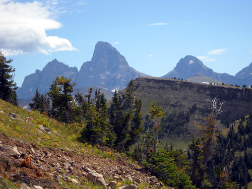
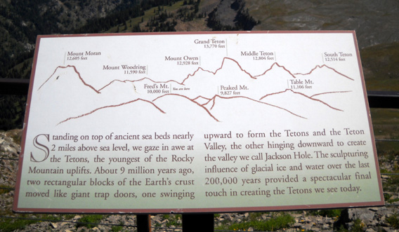
L-R: Mt. Owen (12,928'), Grand Teton
(13,770'), Middle Teton (12,804');
Table Mtn. in foreground. Photo taken from
the service road on Fred's Mtn.
Some of the best Teton views are along the service road, about a
third of a mile below the aid station on the summit of Fred's
Mountain:
That's a great place to get photos of runners on race day! You
can crop them vertically to feature just Mt. Owen and the Grand
Teton in the background. I was standing a little farther up when
I took photos
of Jim and other runners during the 2007 race. Thanks to RD Jay
Batchen for this great photo tip two years ago. (If you're
crewing, either hike up the road during the race or take the
chairlift.)
EASILY DISTRACTED
The day we climbed Fred's, Jim was going faster and was ahead of
Cody and me. He turned at the building where the chairlift lets
passengers out at the summit of the mountain (the location of the aid station during the race)
. . .
Cody runs ahead of me to greet Jim after he
started his descent on Fred's Mountain.
. . .
and returned to Targhee Base so he could more accurately
determine how long it takes to do that section on race day. Then
he added in another five miles on the Mill Creek Trail.
I wasn't planning on running/hiking as many miles as Jim so I
had the luxury of spending 15-20 minutes wandering around the
summit ridge like we did two years ago when we first arrived at
the ski resort.
The race course stops a little short of the high point on Fred's
Mountain. To get the best views, runners and crews should either
climb or ride the lift to the top before race day. The views
down into the Jedediah Smith Wilderness Area and of the western
slope of the Tetons from this close are fabulous.
These shots are from the observation deck a little north of the
chairlift:
I think the views to the southeast are even better from
the rocky pathway on the ridge on the other side of the
chairlift:
My summit scramble turned into a little more excitement than I
expected, however. As we passed the chairlift and a little
building just below the ridge, Cody apparently got too close to
a motion-sensor alarm and set it off! I spent the whole time at
the summit wondering if someone would drive up the mountain to
see what set it off. Hopefully they had a camera down below that
could show them it was just an innocent tourist taking pictures from the ridge, not someone bent on mayhem.
Looking down at the service road we took
between Fred's Mtn. and Peaked Peak.
I took lots of photos that morning -- 110, to be
exact! And that was just up and down Fred's Mountain. I took a
few more more when I drove down to the bottom of the Mill Creek
Trail to meet Jim. He included five miles of Section B into that
run and went almost four miles farther than I did that day.
Race crew had already marked Section A by Tuesday but Mill Creek
and Rick's Basin weren't marked until later in the week. Not
that we needed markers for Fred's Mountain, however --
Jim pointed me up the correct dirt road and I simply followed it
to the top.
I SPY . . . NEW TRAILS!
Although I hadn't been up this service road before, I've looked
down on most of it and the southwestern side of the mountain
from the chairlift and the summit a couple times in 2007. I knew
there weren't any nice dirt trails on that side of the mountain
then -- but now there are some trails! They
cross the service road several times. I noted their locations
and read the signs as I hiked up the mountain.
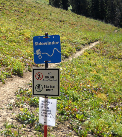
Rats. Unfortunately, these lovely trails are only for
cyclists, not runners. And only downhill. The
cyclists and their bikes hitch a ride up the mountain on the
chairlift (I say real mountain bikers would pedal their
bikes up that mountain!) and bomb down the trails in protective
gear, if they want to live through the joy ride.
This setup is a good little money-maker for Grand Targhee Resort
and fairly cost effective for diehard downhill cyclists who live
within a reasonable driving distance. Cyclists (and presumably
anyone else) could get unlimited summer chairlift access from
June 22 to the middle of September for $99. One single trip on
the chairlift costs $15 now, or $20 per day. When we were here
two years ago we were able to buy a nice Lunch 'n Lift ticket
for only $15;. now it's over $20, depending on your menu
selection.
A section of the Sidewinder bike trail,
looking up toward the summit of Fred's Mtn.
Grand Targhee has a fairly extensive system of hiking, cycling,
and equestrian trails. Bikes are allowed on nearly all the
trails and roads so we had to be careful all week when we were
running on resort property. I hope they aren't a problem for
runners in the race tomorrow. The resort really caters to
cyclists now, with various bike clinics, group rides, and
several races throughout the summer -- including 50-mile,
100-mile, and 24-hour endurance events.
[Addendum: after the summer season closed, the resort
reported record attendance this
year, primarily because of the new downhill biking trails and
series of bike races. "Grand Targhee Resort is exploring the
addition of an expert downhill trail above the existing
Sidewinder Trail, an event-caliber downhill course along Rock
Garden ridge, expanding the cross country trails in Rick’s Basin
and creating a cross-country trail system on Peaked Mountain for
next summer. The resort will be working with the Caribou-Targhee
National Forest to develop additional trails, and all new trails
are subject to US Forest Service approval."]
WHY NOT??
I noted on the way up Fred's on Tuesday that the chairlift
wasn't operating that morning. It apparently doesn't start until
1 PM on weekdays this time of year, since it's past the prime
summer season and kids are back in school. I hadn't seen any
folks riding bikes up the road I was on, which is the only other
way for cyclists to get up that mountain, so . . .
You must know by now what went through my mind when I saw
unused trails!
Hmmm . . .
it sure would be more fun and easier on my Granny Knees to run
down those dirt trails instead of this rocky road!
There's a new bike trail (not shown here)
just to the right of this road near the top of Fred's Mtn.
Yep, I'm a scofflaw. After exploring the summit, Cody and I
hopped on the connector trail that parallels the road near the
top of the mountain. Then we peeled off onto the Sidewinder
Trail, which I'd been admiring from the road on the way up. I
later learned that it's rated intermediate difficulty for
cyclists. It has more switchbacks and drops more gradually than
the "expert" rated Buffalo Drop Trail.
We followed Sidewinder part way down to Targhee Base. Even
though I didn't think there were any bikes on the mountain, I
turned around frequently to make sure we didn't get run over or
get in anyone's way. There was no bike traffic in the vicinity.
Since pedestrians are prohibited from using the downhill
bike trails, I also watched carefully for resort staff when I was
within sight of the road. Two vehicles did go up the mountain
about 12:30, shortly before the chairlift was to open,
but Cody and I were already back on the road by then. If anyone
saw me running the trails via surveillance camera (am I
paranoid, or what?), they didn't say anything.
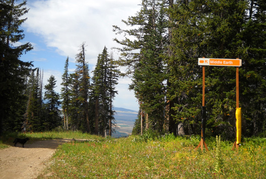
This sign points to Middle Earth, the area
between ski runs on Fred's Mtn. and Peaked Peak.
Ski runs have names like Lost Groomer,
Crazy Horse, and Wandering Moose.
Stealth running! That added even more excitement to the
morning's adventure on Fred's Mountain. I wish the Grand Teton
foot race could incorporate this trail into the official course instead of
the rocky service road up to Fred's summit.
Continued in
Part 2: lots more photos
from the Mill Creek Trail and Ricks Basin
Happy trails,
Sue
"Runtrails & Company" - Sue Norwood, Jim O'Neil,
and Cody the Ultra Lab
Previous
Next
© 2009 Sue Norwood and Jim O'Neil